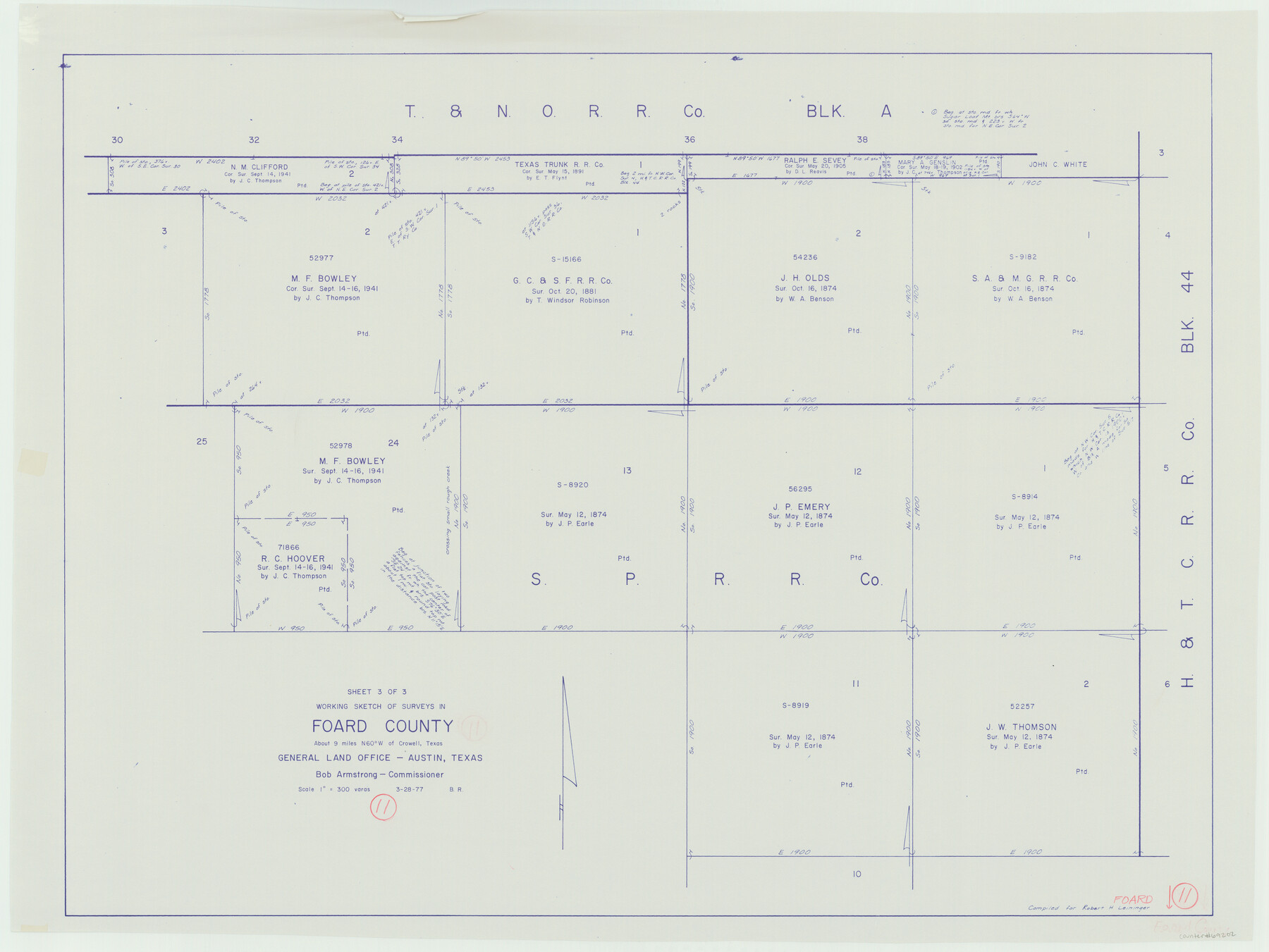
Foard County Working Sketch 11
-
Map/Doc
69202
-
Collection
General Map Collection
-
Object Dates
3/28/1977 (Creation Date)
-
People and Organizations
Beverly Robison (Draftsman)
-
Counties
Foard
-
Subjects
Surveying Working Sketch
-
Height x Width
26.7 x 35.6 inches
67.8 x 90.4 cm
-
Scale
1" = 300 varas
Part of: General Map Collection
Plan of the City of Calhoun

Print $40.00
- Digital $50.00
Plan of the City of Calhoun
1839
Size 49.7 x 58.9 inches
Map/Doc 2175

Culberson County Working Sketch 47

Print $20.00
- Digital $50.00
Culberson County Working Sketch 47
1971
Size 25.7 x 36.5 inches
Map/Doc 68501
King County Boundary File 5

Print $12.00
- Digital $50.00
King County Boundary File 5
Size 14.2 x 8.8 inches
Map/Doc 64916
Flight Mission No. DCL-6C, Frame 22, Kenedy County

Print $20.00
- Digital $50.00
Flight Mission No. DCL-6C, Frame 22, Kenedy County
1943
Size 18.6 x 22.3 inches
Map/Doc 85879
San Jacinto County Sketch File 7

Print $10.00
- Digital $50.00
San Jacinto County Sketch File 7
1848
Size 8.1 x 10.0 inches
Map/Doc 35705
Flight Mission No. DQN-3K, Frame 10, Calhoun County

Print $20.00
- Digital $50.00
Flight Mission No. DQN-3K, Frame 10, Calhoun County
1953
Size 18.5 x 22.2 inches
Map/Doc 84342
Trinity River, McKinney Sheet/East Fork of Trinity River

Print $20.00
- Digital $50.00
Trinity River, McKinney Sheet/East Fork of Trinity River
1931
Size 40.6 x 28.0 inches
Map/Doc 65241
Roberts County Working Sketch 37

Print $20.00
- Digital $50.00
Roberts County Working Sketch 37
1978
Size 26.6 x 22.5 inches
Map/Doc 63563
Flight Mission No. DQN-6K, Frame 12, Calhoun County

Print $20.00
- Digital $50.00
Flight Mission No. DQN-6K, Frame 12, Calhoun County
1953
Size 18.6 x 22.2 inches
Map/Doc 84434
Bandera County Boundary File 4b

Print $16.00
- Digital $50.00
Bandera County Boundary File 4b
Size 13.0 x 8.1 inches
Map/Doc 50281
Map of Comal County

Print $20.00
- Digital $50.00
Map of Comal County
1862
Size 18.6 x 22.0 inches
Map/Doc 3429
You may also like
San Jacinto County Working Sketch 40

Print $40.00
- Digital $50.00
San Jacinto County Working Sketch 40
1971
Size 43.9 x 59.8 inches
Map/Doc 63753
Marion County Sketch File 13

Print $24.00
- Digital $50.00
Marion County Sketch File 13
1912
Size 11.3 x 8.7 inches
Map/Doc 30583
Presidio County Sketch File 60a

Print $4.00
- Digital $50.00
Presidio County Sketch File 60a
1936
Size 8.7 x 15.5 inches
Map/Doc 34643

Jefferson County Sketch File 14

Print $60.00
- Digital $50.00
Jefferson County Sketch File 14
Size 15.8 x 13.2 inches
Map/Doc 28149
Webb County Working Sketch 46

Print $20.00
- Digital $50.00
Webb County Working Sketch 46
1947
Size 18.4 x 23.5 inches
Map/Doc 72411
Motley County Boundary File 2e

Print $40.00
- Digital $50.00
Motley County Boundary File 2e
Size 29.4 x 96.1 inches
Map/Doc 57561
Polk County Sketch File 28

Print $4.00
- Digital $50.00
Polk County Sketch File 28
Size 8.6 x 9.9 inches
Map/Doc 34198
Motley County Sketch File 1 (N)

Print $4.00
- Digital $50.00
Motley County Sketch File 1 (N)
Size 11.4 x 6.7 inches
Map/Doc 31994
Eastland County Working Sketch 42

Print $20.00
- Digital $50.00
Eastland County Working Sketch 42
1979
Size 43.5 x 35.0 inches
Map/Doc 68823
Castro County Sketch File 4k

Print $4.00
- Digital $50.00
Castro County Sketch File 4k
Size 13.6 x 8.6 inches
Map/Doc 17485
[Sketch Showing Wm. T. Brewer, John R. Taylor, Wm. F. Butler, Timothy DeVore, L. M. Thorn and adjoining surveys]
![90230, [Sketch Showing Wm. T. Brewer, John R. Taylor, Wm. F. Butler, Timothy DeVore, L. M. Thorn and adjoining surveys], Twichell Survey Records](https://historictexasmaps.com/wmedia_w700/maps/90230-1.tif.jpg)
Print $20.00
- Digital $50.00
[Sketch Showing Wm. T. Brewer, John R. Taylor, Wm. F. Butler, Timothy DeVore, L. M. Thorn and adjoining surveys]
Size 25.1 x 19.2 inches
Map/Doc 90230