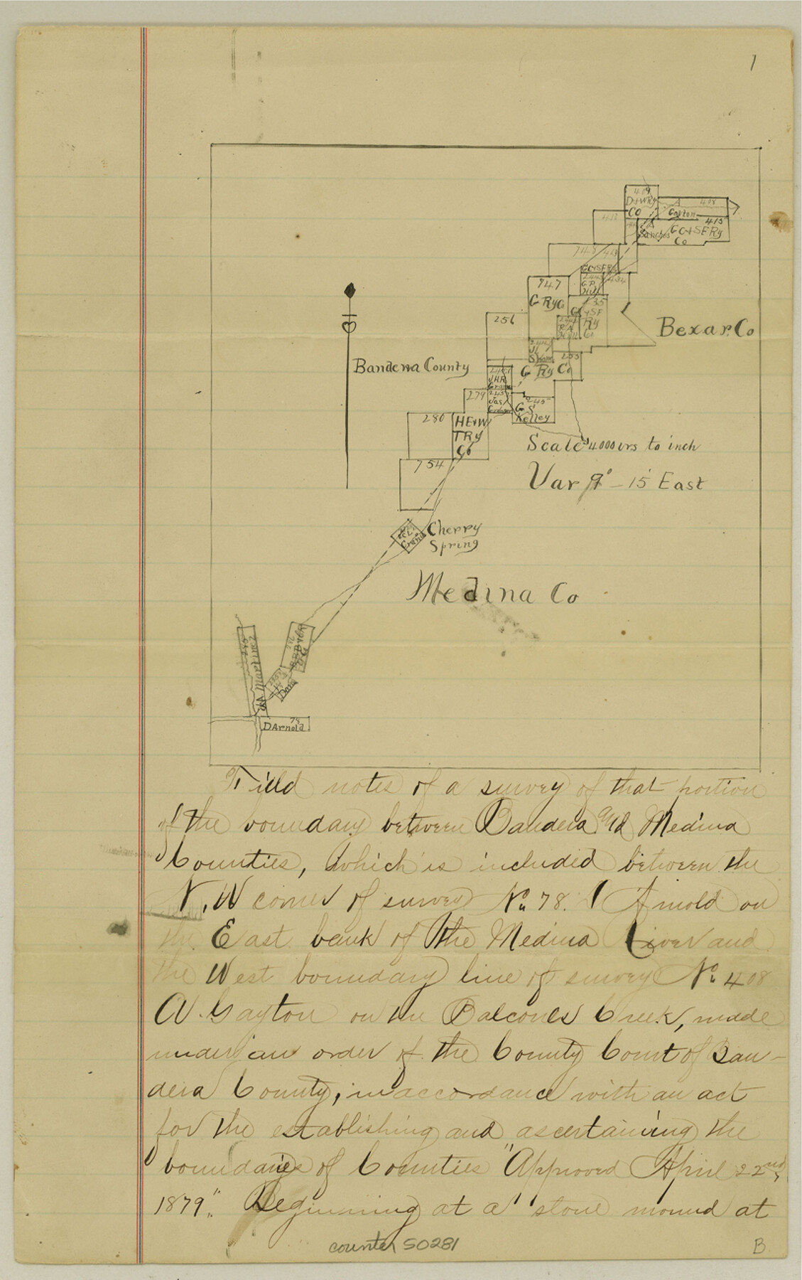
Bandera County Boundary File 4b
Fieldnotes of Boundary Line between Bandera and Medina Counties
-
Map/Doc
50281
-
Collection
General Map Collection
-
Counties
Bandera
-
Subjects
County Boundaries
-
Height x Width
13.0 x 8.1 inches
33.0 x 20.6 cm
Part of: General Map Collection

Potter County Sketch File 22

Print $30.00
- Digital $50.00
Potter County Sketch File 22
1962
Size 14.2 x 8.6 inches
Map/Doc 34415
Webb County Working Sketch 30

Print $20.00
- Digital $50.00
Webb County Working Sketch 30
1934
Size 15.0 x 40.6 inches
Map/Doc 72395
Calcasieu Pass to Sabine Pass

Print $20.00
- Digital $50.00
Calcasieu Pass to Sabine Pass
1925
Size 44.1 x 36.0 inches
Map/Doc 69804
Bell County Working Sketch 18

Print $20.00
- Digital $50.00
Bell County Working Sketch 18
1984
Size 36.2 x 29.8 inches
Map/Doc 67358
[Maps of surveys in Reeves & Culberson Cos]
![61148, [Maps of surveys in Reeves & Culberson Cos], General Map Collection](https://historictexasmaps.com/wmedia_w700/maps/61148.tif.jpg)
Print $20.00
- Digital $50.00
[Maps of surveys in Reeves & Culberson Cos]
1937
Size 30.7 x 24.9 inches
Map/Doc 61148
Flight Mission No. DAG-24K, Frame 140, Matagorda County

Print $20.00
- Digital $50.00
Flight Mission No. DAG-24K, Frame 140, Matagorda County
1953
Size 17.0 x 15.6 inches
Map/Doc 86558
Cochran County Sketch File 4

Print $20.00
- Digital $50.00
Cochran County Sketch File 4
1931
Size 24.9 x 22.1 inches
Map/Doc 11100
Lipscomb County Boundary File 12

Print $4.00
- Digital $50.00
Lipscomb County Boundary File 12
Size 10.6 x 8.1 inches
Map/Doc 56351
Jones County Sketch File 11

Print $6.00
- Digital $50.00
Jones County Sketch File 11
1875
Size 11.1 x 8.7 inches
Map/Doc 28496
Culberson County Rolled Sketch 43

Print $20.00
- Digital $50.00
Culberson County Rolled Sketch 43
1947
Size 20.5 x 36.7 inches
Map/Doc 5664
Duval County Sketch File 15

Print $4.00
- Digital $50.00
Duval County Sketch File 15
Size 12.0 x 9.0 inches
Map/Doc 21309
You may also like
Garza County Sketch File 2

Print $20.00
- Digital $50.00
Garza County Sketch File 2
Size 33.1 x 30.3 inches
Map/Doc 10462
Carte d'Amerique, Divisee en ses Principaux Pays, Dressee sur les Memoires les plus recents, et sur differents Voyages, et assujettie aux observations Astronomiques de Mrs. de l'Academie Royale des Sciences

Print $40.00
- Digital $50.00
Carte d'Amerique, Divisee en ses Principaux Pays, Dressee sur les Memoires les plus recents, et sur differents Voyages, et assujettie aux observations Astronomiques de Mrs. de l'Academie Royale des Sciences
1787
Size 43.5 x 51.3 inches
Map/Doc 96430
Eastland County Sketch File 8

Print $8.00
- Digital $50.00
Eastland County Sketch File 8
1872
Size 12.9 x 8.1 inches
Map/Doc 21576
El Paso County Boundary File 4b

Print $24.00
- Digital $50.00
El Paso County Boundary File 4b
Size 12.3 x 9.0 inches
Map/Doc 53066
Wise County Fannin District

Print $20.00
- Digital $50.00
Wise County Fannin District
1878
Size 27.3 x 21.2 inches
Map/Doc 4164
King County Sketch File 6 (1)

Print $43.00
- Digital $50.00
King County Sketch File 6 (1)
1897
Size 14.5 x 15.7 inches
Map/Doc 29027
Dimmit County Sketch File 29

Print $40.00
- Digital $50.00
Dimmit County Sketch File 29
1877
Size 26.5 x 22.1 inches
Map/Doc 11351
[M. B. & B. Blks. A, B & C near Coyote Lake]
![90249, [M. B. & B. Blks. A, B & C near Coyote Lake], Twichell Survey Records](https://historictexasmaps.com/wmedia_w700/maps/90249-1.tif.jpg)
Print $20.00
- Digital $50.00
[M. B. & B. Blks. A, B & C near Coyote Lake]
Size 15.4 x 23.3 inches
Map/Doc 90249
El Paso County Sketch File 35 (6)

Print $20.00
- Digital $50.00
El Paso County Sketch File 35 (6)
1886
Size 20.3 x 36.9 inches
Map/Doc 11460
Coryell County Sketch File 17 1/4

Print $4.00
- Digital $50.00
Coryell County Sketch File 17 1/4
Size 8.7 x 14.9 inches
Map/Doc 19377
Mills County Working Sketch 8

Print $20.00
- Digital $50.00
Mills County Working Sketch 8
1919
Size 27.6 x 23.3 inches
Map/Doc 71038
Red River County Working Sketch 79

Print $40.00
- Digital $50.00
Red River County Working Sketch 79
1986
Size 43.8 x 61.1 inches
Map/Doc 72062