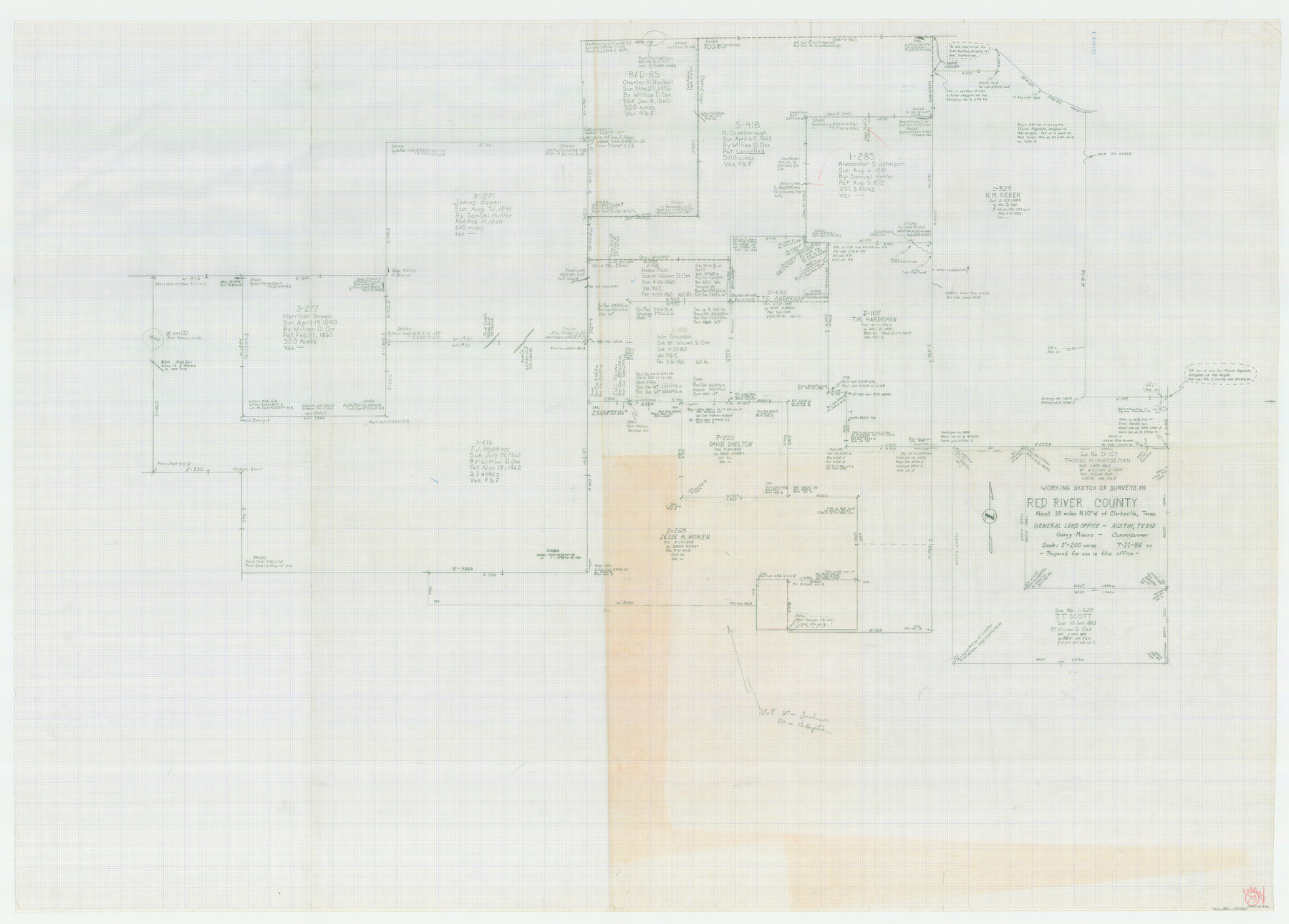
Red River County Working Sketch 79
-
Map/Doc
72062
-
Collection
General Map Collection
-
Object Dates
7/11/1986 (Creation Date)
-
People and Organizations
Charles Strauch (Draftsman)
-
Counties
Red River
-
Subjects
Surveying Working Sketch
-
Height x Width
43.8 x 61.1 inches
111.3 x 155.2 cm
-
Scale
1" = 200 varas
Part of: General Map Collection
San Patricio County Rolled Sketch 29

Print $20.00
- Digital $50.00
San Patricio County Rolled Sketch 29
Size 39.2 x 45.5 inches
Map/Doc 9893
El Paso County Working Sketch 26

Print $20.00
- Digital $50.00
El Paso County Working Sketch 26
1963
Size 35.4 x 18.6 inches
Map/Doc 69048

Maps of Gulf Intracoastal Waterway, Texas - Sabine River to the Rio Grande and connecting waterways including ship channels

Print $20.00
- Digital $50.00
Maps of Gulf Intracoastal Waterway, Texas - Sabine River to the Rio Grande and connecting waterways including ship channels
1966
Size 14.5 x 22.2 inches
Map/Doc 61928
Palo Pinto County

Print $40.00
- Digital $50.00
Palo Pinto County
1941
Size 49.4 x 40.4 inches
Map/Doc 95606
Trinity River, Terrell Sheet/Kings Creek

Print $20.00
- Digital $50.00
Trinity River, Terrell Sheet/Kings Creek
1930
Size 42.3 x 19.7 inches
Map/Doc 65229
Red River County Working Sketch 76

Print $20.00
- Digital $50.00
Red River County Working Sketch 76
1980
Size 17.7 x 33.9 inches
Map/Doc 72059
Hamilton County

Print $20.00
- Digital $50.00
Hamilton County
1898
Size 35.3 x 42.5 inches
Map/Doc 66849
Randall County Sketch File 10

Print $4.00
- Digital $50.00
Randall County Sketch File 10
1941
Size 11.4 x 8.8 inches
Map/Doc 34972
Map of Nacogdoches County

Print $20.00
- Digital $50.00
Map of Nacogdoches County
1881
Size 24.5 x 21.8 inches
Map/Doc 4604
Polk County Sketch File 29

Print $4.00
- Digital $50.00
Polk County Sketch File 29
Size 8.8 x 12.6 inches
Map/Doc 34200
Comanche County Sketch File 2

Print $40.00
- Digital $50.00
Comanche County Sketch File 2
1849
Size 16.0 x 12.9 inches
Map/Doc 19053
You may also like
Nueces County Rolled Sketch 54

Print $67.00
- Digital $50.00
Nueces County Rolled Sketch 54
1978
Size 9.8 x 15.0 inches
Map/Doc 47875
Travis County

Print $40.00
- Digital $50.00
Travis County
1936
Size 47.0 x 53.7 inches
Map/Doc 73305
McCulloch County Rolled Sketch 11

Print $20.00
- Digital $50.00
McCulloch County Rolled Sketch 11
1992
Size 46.3 x 40.3 inches
Map/Doc 9499
Map of Austin's Li[ttle Colony Above the] San [Antonio Road]
![215, Map of Austin's Li[ttle Colony Above the] San [Antonio Road], General Map Collection](https://historictexasmaps.com/wmedia_w700/maps/215.tif.jpg)
Print $20.00
- Digital $50.00
Map of Austin's Li[ttle Colony Above the] San [Antonio Road]
1831
Size 14.2 x 19.3 inches
Map/Doc 215
[Section 2, Block 5, Dawson County, Texas]
![92617, [Section 2, Block 5, Dawson County, Texas], Twichell Survey Records](https://historictexasmaps.com/wmedia_w700/maps/92617-1.tif.jpg)
Print $2.00
- Digital $50.00
[Section 2, Block 5, Dawson County, Texas]
Size 9.2 x 12.3 inches
Map/Doc 92617
Travis County Sketch File 15

Print $4.00
- Digital $50.00
Travis County Sketch File 15
Size 12.8 x 8.1 inches
Map/Doc 38310
Briscoe County Working Sketch Graphic Index

Print $20.00
- Digital $50.00
Briscoe County Working Sketch Graphic Index
1930
Size 43.8 x 37.4 inches
Map/Doc 76478
Part of Garza, Crosby, Lynn, and Lubbock Counties

Print $20.00
- Digital $50.00
Part of Garza, Crosby, Lynn, and Lubbock Counties
1912
Size 24.7 x 20.4 inches
Map/Doc 91324
Comment on Illustrations [SMS Ranch Booklet]
![96594, Comment on Illustrations [SMS Ranch Booklet], Cobb Digital Map Collection](https://historictexasmaps.com/wmedia_w700/pdf_converted_jpg/qi_pdf_thumbnail_40597.jpg)
Comment on Illustrations [SMS Ranch Booklet]
1916
Size 6.1 x 9.2 inches
Map/Doc 96594
Liberty County Sketch File 17

Print $2.00
- Digital $50.00
Liberty County Sketch File 17
Size 8.2 x 3.2 inches
Map/Doc 29919
Map of the City of San Antonio, Bexar County, Texas including suburbs, north and south

Print $20.00
- Digital $50.00
Map of the City of San Antonio, Bexar County, Texas including suburbs, north and south
Size 39.6 x 26.6 inches
Map/Doc 96511
Maps of Gulf Intracoastal Waterway, Texas - Sabine River to the Rio Grande and connecting waterways including ship channels

Print $20.00
- Digital $50.00
Maps of Gulf Intracoastal Waterway, Texas - Sabine River to the Rio Grande and connecting waterways including ship channels
1966
Size 14.5 x 22.3 inches
Map/Doc 61933