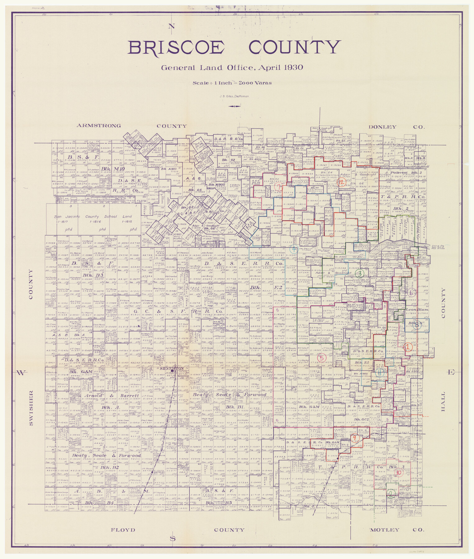
Briscoe County Working Sketch Graphic Index
-
Map/Doc
76478
-
Collection
General Map Collection
-
Object Dates
4/1930 (Creation Date)
-
People and Organizations
J.B. Giles (Draftsman)
-
Counties
Briscoe
-
Subjects
County Surveying Working Sketch
-
Height x Width
43.8 x 37.4 inches
111.3 x 95.0 cm
-
Scale
1" = 2000 varas
Part of: General Map Collection
Hudspeth County Rolled Sketch 52

Print $20.00
- Digital $50.00
Hudspeth County Rolled Sketch 52
1975
Size 27.2 x 21.6 inches
Map/Doc 6257
Presidio County Rolled Sketch 13

Print $40.00
- Digital $50.00
Presidio County Rolled Sketch 13
1882
Size 59.1 x 43.9 inches
Map/Doc 78487
Bandera County Sketch File 28

Print $40.00
- Digital $50.00
Bandera County Sketch File 28
Size 23.5 x 20.0 inches
Map/Doc 10897
Zavala County Rolled Sketch 27

Print $20.00
- Digital $50.00
Zavala County Rolled Sketch 27
1955
Size 21.2 x 20.0 inches
Map/Doc 8329
San Augustine County Boundary File 1

Print $17.00
- Digital $50.00
San Augustine County Boundary File 1
Size 9.3 x 12.2 inches
Map/Doc 58540
Freestone County Sketch File 6

Print $4.00
- Digital $50.00
Freestone County Sketch File 6
1858
Size 10.3 x 8.8 inches
Map/Doc 23050
Parker County Working Sketch 17

Print $20.00
- Digital $50.00
Parker County Working Sketch 17
1996
Map/Doc 71467
Aransas County Sketch File 23

Print $6.00
- Digital $50.00
Aransas County Sketch File 23
1927
Size 14.5 x 8.9 inches
Map/Doc 13174
Culberson County Working Sketch 11

Print $20.00
- Digital $50.00
Culberson County Working Sketch 11
1920
Size 29.6 x 22.9 inches
Map/Doc 68463
Potter County Boundary File 5b

Print $22.00
- Digital $50.00
Potter County Boundary File 5b
Size 4.1 x 4.9 inches
Map/Doc 58025
Railroad Track Map, H&TCRRCo., Falls County, Texas

Print $4.00
- Digital $50.00
Railroad Track Map, H&TCRRCo., Falls County, Texas
1918
Size 11.4 x 18.7 inches
Map/Doc 62849
Aransas County Working Sketch 14

Print $20.00
- Digital $50.00
Aransas County Working Sketch 14
1951
Size 22.5 x 22.3 inches
Map/Doc 67181
You may also like
Mapa del Presidio de San Antonio de Bexar, i sus Misiones de la Provinsia de Texas

Print $20.00
Mapa del Presidio de San Antonio de Bexar, i sus Misiones de la Provinsia de Texas
1764
Size 14.5 x 18.4 inches
Map/Doc 94455
[Sketch showing Jeff Davis County, Blocks 1, 2, 3, 4, 360, 363 and JG1]
![91776, [Sketch showing Jeff Davis County, Blocks 1, 2, 3, 4, 360, 363 and JG1], Twichell Survey Records](https://historictexasmaps.com/wmedia_w700/maps/91776-1.tif.jpg)
Print $20.00
- Digital $50.00
[Sketch showing Jeff Davis County, Blocks 1, 2, 3, 4, 360, 363 and JG1]
Size 20.5 x 13.7 inches
Map/Doc 91776
Val Verde County Rolled Sketch 36

Print $40.00
- Digital $50.00
Val Verde County Rolled Sketch 36
Size 49.6 x 43.7 inches
Map/Doc 10072
Tom Green County Rolled Sketch 1

Print $20.00
- Digital $50.00
Tom Green County Rolled Sketch 1
Size 29.8 x 25.4 inches
Map/Doc 7991
Flight Mission No. CRC-4R, Frame 105, Chambers County

Print $20.00
- Digital $50.00
Flight Mission No. CRC-4R, Frame 105, Chambers County
1956
Size 18.8 x 22.4 inches
Map/Doc 84902
Map of the Aransas Pass Transit Railway

Print $40.00
- Digital $50.00
Map of the Aransas Pass Transit Railway
1890
Size 23.9 x 60.9 inches
Map/Doc 64369
Crosby County Working Sketch 11

Print $20.00
- Digital $50.00
Crosby County Working Sketch 11
1947
Size 23.7 x 22.8 inches
Map/Doc 68445
[Vague Sketches in Brooks County, Texas]
![83352, [Vague Sketches in Brooks County, Texas], Maddox Collection](https://historictexasmaps.com/wmedia_w700/maps/83352.tif.jpg)
Print $20.00
- Digital $50.00
[Vague Sketches in Brooks County, Texas]
1906
Size 17.8 x 19.9 inches
Map/Doc 83352
Leftwich Empresario Colony. April 15, 1825

Print $20.00
Leftwich Empresario Colony. April 15, 1825
2020
Size 19.5 x 21.7 inches
Map/Doc 95997
Lavaca County Working Sketch 18

Print $20.00
- Digital $50.00
Lavaca County Working Sketch 18
1979
Size 37.0 x 20.3 inches
Map/Doc 70371
Map of Texas with population and location of principal towns and cities, according to latest reliable statistics

Print $20.00
- Digital $50.00
Map of Texas with population and location of principal towns and cities, according to latest reliable statistics
1906
Size 18.9 x 22.4 inches
Map/Doc 95869
Burleson County Working Sketch 11

Print $20.00
- Digital $50.00
Burleson County Working Sketch 11
1980
Size 18.7 x 17.0 inches
Map/Doc 67730