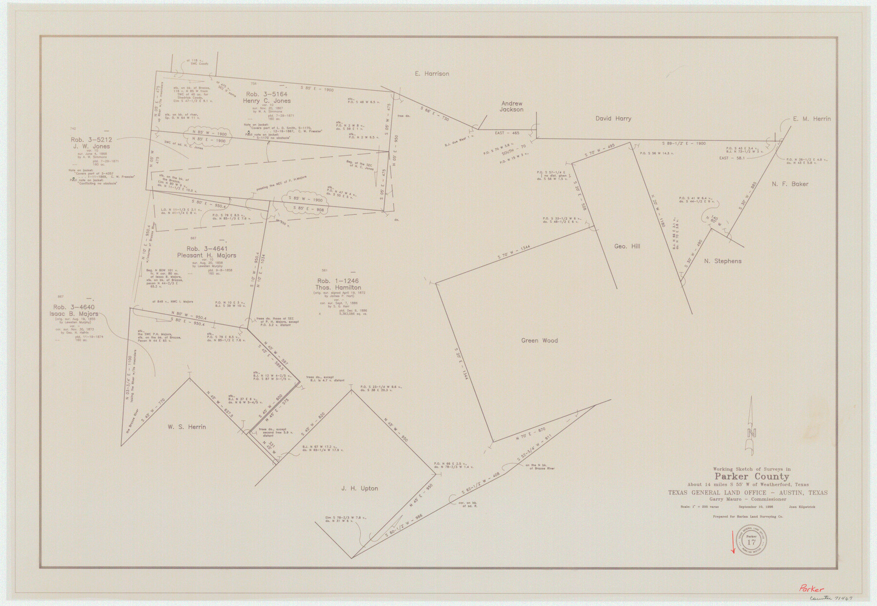
Parker County Working Sketch 17
-
Map/Doc
71467
-
Collection
General Map Collection
-
Object Dates
9/10/1996 (Creation Date)
-
People and Organizations
Joan Kilpatrick (Draftsman)
-
Counties
Parker
-
Subjects
Surveying Working Sketch
-
Scale
1" = 200 varas
Part of: General Map Collection
Wharton County Sketch File A2

Print $32.00
- Digital $50.00
Wharton County Sketch File A2
1898
Size 22.1 x 15.7 inches
Map/Doc 12670
Matagorda County NRC Article 33.136 Sketch 15

Print $42.00
- Digital $50.00
Matagorda County NRC Article 33.136 Sketch 15
Size 23.8 x 35.9 inches
Map/Doc 95739
Flight Mission No. BQR-3K, Frame 155, Brazoria County

Print $20.00
- Digital $50.00
Flight Mission No. BQR-3K, Frame 155, Brazoria County
1952
Size 18.7 x 22.4 inches
Map/Doc 83982
Val Verde County Working Sketch 93

Print $20.00
- Digital $50.00
Val Verde County Working Sketch 93
1976
Size 40.9 x 40.6 inches
Map/Doc 72228
Pecos County Rolled Sketch 174

Print $20.00
- Digital $50.00
Pecos County Rolled Sketch 174
Size 23.3 x 25.0 inches
Map/Doc 7294
Brazos River, Sandpit Extension Sheet

Print $20.00
- Digital $50.00
Brazos River, Sandpit Extension Sheet
1926
Size 31.3 x 36.5 inches
Map/Doc 69663
Flight Mission No. BRE-2P, Frame 25, Nueces County

Print $20.00
- Digital $50.00
Flight Mission No. BRE-2P, Frame 25, Nueces County
1956
Size 18.4 x 22.2 inches
Map/Doc 86734
Comanche County Working Sketch 8

Print $20.00
- Digital $50.00
Comanche County Working Sketch 8
1950
Size 29.1 x 24.8 inches
Map/Doc 68142
Nueces County Rolled Sketch 127 A-F

Print $22.00
Nueces County Rolled Sketch 127 A-F
1998
Size 11.1 x 26.6 inches
Map/Doc 8976
Harris County NRC Article 33.136 Sketch 16

Print $20.00
- Digital $50.00
Harris County NRC Article 33.136 Sketch 16
2006
Size 24.0 x 36.0 inches
Map/Doc 94823
Lynn County Sketch File 17

Print $20.00
- Digital $50.00
Lynn County Sketch File 17
Size 13.2 x 20.9 inches
Map/Doc 12020
Flight Mission No. BRE-2P, Frame 39, Nueces County

Print $20.00
- Digital $50.00
Flight Mission No. BRE-2P, Frame 39, Nueces County
1956
Size 18.6 x 22.4 inches
Map/Doc 86741
You may also like
[Gulf Colorado & Santa Fe from 2178+36.0 to 3901+06.2]
![64695, [Gulf Colorado & Santa Fe from 2178+36.0 to 3901+06.2], General Map Collection](https://historictexasmaps.com/wmedia_w700/maps/64695-1.tif.jpg)
Print $40.00
- Digital $50.00
[Gulf Colorado & Santa Fe from 2178+36.0 to 3901+06.2]
Size 33.6 x 120.7 inches
Map/Doc 64695
Flight Mission No. DIX-7P, Frame 89, Aransas County

Print $20.00
- Digital $50.00
Flight Mission No. DIX-7P, Frame 89, Aransas County
1956
Size 18.7 x 22.4 inches
Map/Doc 83883
Orange County Working Sketch 20

Print $20.00
- Digital $50.00
Orange County Working Sketch 20
1933
Size 16.0 x 23.3 inches
Map/Doc 71352
Leon County Rolled Sketch 25

Print $20.00
- Digital $50.00
Leon County Rolled Sketch 25
Size 47.3 x 36.2 inches
Map/Doc 9434
Nueces County NRC Article 33.136 Location Key Sheet

Print $20.00
- Digital $50.00
Nueces County NRC Article 33.136 Location Key Sheet
1975
Size 27.0 x 22.8 inches
Map/Doc 77033
Atlas E, Sketch 29 (E-29)

Print $20.00
- Digital $50.00
Atlas E, Sketch 29 (E-29)
Size 22.4 x 33.2 inches
Map/Doc 78363
Hale County Sketch File C

Print $20.00
- Digital $50.00
Hale County Sketch File C
1901
Size 20.1 x 24.1 inches
Map/Doc 11600
Kent County Rolled Sketch 4

Print $20.00
- Digital $50.00
Kent County Rolled Sketch 4
1950
Size 22.1 x 31.1 inches
Map/Doc 6475
[Surveying sketch of Jones County showing Micaela Fiagoso survey]
![387, [Surveying sketch of Jones County showing Micaela Fiagoso survey], Maddox Collection](https://historictexasmaps.com/wmedia_w700/maps/0387-1.tif.jpg)
Print $20.00
- Digital $50.00
[Surveying sketch of Jones County showing Micaela Fiagoso survey]
Size 19.5 x 16.8 inches
Map/Doc 387
Duval County Rolled Sketch 20

Print $20.00
- Digital $50.00
Duval County Rolled Sketch 20
Size 33.2 x 42.0 inches
Map/Doc 8811
Lynn County Rolled Sketch 16

Print $20.00
- Digital $50.00
Lynn County Rolled Sketch 16
1991
Size 18.3 x 42.3 inches
Map/Doc 6652
Bowie County Working Sketch 6

Print $20.00
- Digital $50.00
Bowie County Working Sketch 6
1928
Size 27.4 x 22.9 inches
Map/Doc 67410