Matagorda County NRC Article 33.136 Sketch 15
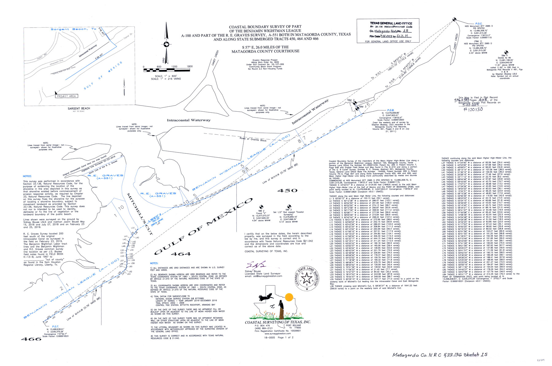
Coastal boundary survey of part of the Benjamin Wightman league A-100 and part of the R.E. Graves survey, A-551 both in Matagorda County, Texas and along State Submerged Tracts 450, 464, and 466
-
Map/Doc
95739
-
Collection
General Map Collection
-
Object Dates
2018/7/7 (Survey Date)
2018/5/15 (Survey Date)
2019/7/16 (File Date)
2019/2/23 (Survey Date)
2019/2/25 (Survey Date)
-
People and Organizations
Joann Bouse (Chainman/Field Personnel)
Sidney Bouse (Surveyor/Engineer)
-
Counties
Matagorda
-
Subjects
Surveying CBS
-
Height x Width
23.8 x 35.9 inches
60.5 x 91.2 cm
-
Medium
multi-page, multi-format
-
Comments
Project: Sargent Beach West - Benjamin Wightman A-100, Matagorda County Project No.: Atkins Work Order No. A932, Under GLO Contract No. 18-127-006, Community Block Grant Program Ike Round 2.2 Non-Housing Funds
Part of: General Map Collection
Shackelford County Rolled Sketch 5

Print $20.00
- Digital $50.00
Shackelford County Rolled Sketch 5
1984
Size 23.1 x 37.1 inches
Map/Doc 7773
Scurry County Boundary File 1

Print $74.00
- Digital $50.00
Scurry County Boundary File 1
Size 9.2 x 3.8 inches
Map/Doc 58597
Henderson County Working Sketch 33

Print $20.00
- Digital $50.00
Henderson County Working Sketch 33
1963
Size 31.2 x 29.3 inches
Map/Doc 66166
Karnes County Rolled Sketch 3

Print $20.00
- Digital $50.00
Karnes County Rolled Sketch 3
1959
Size 27.9 x 41.6 inches
Map/Doc 6454
Current Miscellaneous File 36

Print $12.00
- Digital $50.00
Current Miscellaneous File 36
Size 10.3 x 12.4 inches
Map/Doc 73952
University Land Loving-Ward-Winkler Counties

Print $20.00
- Digital $50.00
University Land Loving-Ward-Winkler Counties
1931
Size 24.7 x 33.2 inches
Map/Doc 2448
Corpus Christi Pass

Print $20.00
- Digital $50.00
Corpus Christi Pass
1880
Size 45.5 x 41.0 inches
Map/Doc 2694
Flight Mission No. BRA-16M, Frame 87, Jefferson County

Print $20.00
- Digital $50.00
Flight Mission No. BRA-16M, Frame 87, Jefferson County
1953
Size 18.6 x 22.3 inches
Map/Doc 85699
Angelina County Sketch File 32

Print $18.00
- Digital $50.00
Angelina County Sketch File 32
1994
Size 14.2 x 8.6 inches
Map/Doc 13092
Flight Mission No. DQN-1K, Frame 118, Calhoun County

Print $20.00
- Digital $50.00
Flight Mission No. DQN-1K, Frame 118, Calhoun County
1953
Size 18.5 x 22.2 inches
Map/Doc 84184
Flight Mission No. DQN-7K, Frame 91, Calhoun County

Print $20.00
- Digital $50.00
Flight Mission No. DQN-7K, Frame 91, Calhoun County
1953
Size 18.4 x 22.2 inches
Map/Doc 84482
Clay County Boundary File 18a

Print $80.00
- Digital $50.00
Clay County Boundary File 18a
Size 65.3 x 17.3 inches
Map/Doc 51443
You may also like
Refugio County Rolled Sketch 9

Print $20.00
- Digital $50.00
Refugio County Rolled Sketch 9
1955
Size 32.4 x 35.2 inches
Map/Doc 7509
Val Verde County Rolled Sketch 39

Print $20.00
- Digital $50.00
Val Verde County Rolled Sketch 39
Size 21.7 x 33.9 inches
Map/Doc 8115
Fort Bend County Rolled Sketch 16A

Print $60.00
- Digital $50.00
Fort Bend County Rolled Sketch 16A
1890
Size 10.6 x 16.6 inches
Map/Doc 44755
Flight Mission No. DQO-8K, Frame 75, Galveston County

Print $20.00
- Digital $50.00
Flight Mission No. DQO-8K, Frame 75, Galveston County
1952
Size 18.7 x 22.5 inches
Map/Doc 85179
Webb County Sketch File 52

Print $40.00
- Digital $50.00
Webb County Sketch File 52
1939
Size 14.2 x 16.7 inches
Map/Doc 39839
Sketch for Blocks D6, D7, D8 situated in Val Verde County, Texas

Print $40.00
- Digital $50.00
Sketch for Blocks D6, D7, D8 situated in Val Verde County, Texas
1937
Size 100.1 x 40.0 inches
Map/Doc 93166
Floyd County Sketch File 1

Print $5.00
- Digital $50.00
Floyd County Sketch File 1
Size 11.0 x 17.0 inches
Map/Doc 22688
The Republic County of Jefferson. January 29, 1842

Print $20.00
The Republic County of Jefferson. January 29, 1842
2020
Size 22.6 x 21.7 inches
Map/Doc 96199
Hardin County Rolled Sketch 13

Print $20.00
- Digital $50.00
Hardin County Rolled Sketch 13
Size 47.1 x 41.3 inches
Map/Doc 76012
Sutton County Sketch File F

Print $18.00
- Digital $50.00
Sutton County Sketch File F
1906
Size 14.1 x 8.7 inches
Map/Doc 37391
Brewster County Rolled Sketch 148A

Print $20.00
- Digital $50.00
Brewster County Rolled Sketch 148A
1994
Size 28.0 x 36.3 inches
Map/Doc 5314
Rusk County Rolled Sketch 13

Print $20.00
- Digital $50.00
Rusk County Rolled Sketch 13
Size 30.1 x 26.4 inches
Map/Doc 7548