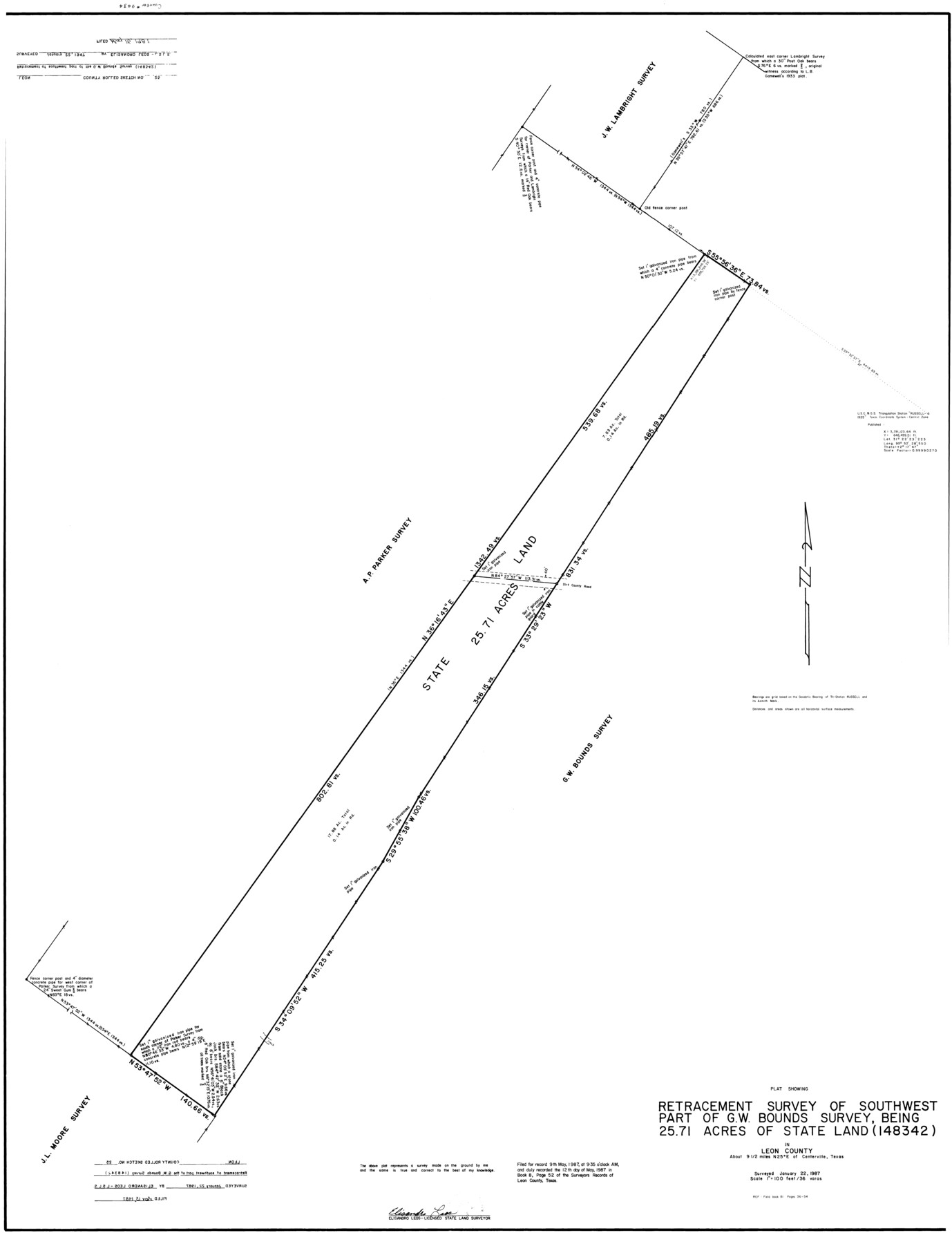
Leon County Rolled Sketch 25
Plat showing retracement survey of southwest part of G.W. Bounds survey, being 25.71 acres of state land (148342) in Leon County
-
Map/Doc
9434
-
Collection
General Map Collection
-
Object Dates
1987/1/22 (Survey Date)
1987/5/15 (File Date)
-
People and Organizations
Elisandro Leos (Surveyor/Engineer)
-
Counties
Leon
-
Subjects
Surveying Rolled Sketch
-
Height x Width
47.3 x 36.2 inches
120.1 x 91.9 cm
-
Medium
mylar, print
-
Scale
1" = 36 varas
Part of: General Map Collection

Matagorda County Rolled Sketch 9

Print $20.00
- Digital $50.00
Matagorda County Rolled Sketch 9
Size 36.8 x 30.0 inches
Map/Doc 6680
Midland County Working Sketch 9

Print $20.00
- Digital $50.00
Midland County Working Sketch 9
1951
Size 42.6 x 35.9 inches
Map/Doc 70989
Map of Liberty County Texas

Print $20.00
- Digital $50.00
Map of Liberty County Texas
1895
Size 29.7 x 29.4 inches
Map/Doc 3811
Hardin County Sketch File 11

Print $8.00
- Digital $50.00
Hardin County Sketch File 11
Size 5.2 x 8.2 inches
Map/Doc 25112
Chambers County Sketch File 24

Print $20.00
- Digital $50.00
Chambers County Sketch File 24
1909
Size 34.1 x 14.5 inches
Map/Doc 11065
Culberson County Working Sketch 84

Print $20.00
- Digital $50.00
Culberson County Working Sketch 84
1980
Size 43.5 x 42.9 inches
Map/Doc 68538
Parker County Sketch File 17

Print $6.00
- Digital $50.00
Parker County Sketch File 17
Size 10.7 x 9.5 inches
Map/Doc 33552
Burleson County Sketch File 10

Print $14.00
- Digital $50.00
Burleson County Sketch File 10
Size 11.5 x 8.3 inches
Map/Doc 16663
Eastland County Working Sketch 18

Print $20.00
- Digital $50.00
Eastland County Working Sketch 18
1919
Size 15.9 x 15.7 inches
Map/Doc 68799
Kimble County Working Sketch 8

Print $20.00
- Digital $50.00
Kimble County Working Sketch 8
1918
Size 27.4 x 12.9 inches
Map/Doc 70076
Outer Continental Shelf Leasing Maps (Texas Offshore Operations)

Print $20.00
- Digital $50.00
Outer Continental Shelf Leasing Maps (Texas Offshore Operations)
Size 24.0 x 18.4 inches
Map/Doc 75853
You may also like
Ector County Working Sketch 26

Print $20.00
- Digital $50.00
Ector County Working Sketch 26
1961
Size 30.8 x 43.6 inches
Map/Doc 68869
Nacogdoches County Working Sketch 6

Print $20.00
- Digital $50.00
Nacogdoches County Working Sketch 6
1955
Size 14.7 x 12.5 inches
Map/Doc 71222
Ward County Working Sketch 25

Print $40.00
- Digital $50.00
Ward County Working Sketch 25
1957
Size 74.3 x 25.6 inches
Map/Doc 72331
Tarrant County Working Sketch 24

Print $20.00
- Digital $50.00
Tarrant County Working Sketch 24
2003
Size 26.0 x 34.9 inches
Map/Doc 78642
Johnson County Working Sketch 20

Print $20.00
- Digital $50.00
Johnson County Working Sketch 20
1991
Size 23.4 x 29.0 inches
Map/Doc 66633
Flight Mission No. BRE-1P, Frame 51, Nueces County

Print $20.00
- Digital $50.00
Flight Mission No. BRE-1P, Frame 51, Nueces County
1956
Size 18.3 x 22.2 inches
Map/Doc 86640
Cameron County Rolled Sketch Z5

Print $20.00
- Digital $50.00
Cameron County Rolled Sketch Z5
1937
Size 28.7 x 33.6 inches
Map/Doc 5403
Southern Pacific Railway and Steamship Lines

Print $20.00
- Digital $50.00
Southern Pacific Railway and Steamship Lines
1900
Size 23.8 x 35.5 inches
Map/Doc 96586
Harris County Sketch File 93

Print $20.00
- Digital $50.00
Harris County Sketch File 93
1952
Size 33.0 x 14.5 inches
Map/Doc 11676
Map of Matagorda & Carancahua Bays in Jackson, Calhoun & Matagorda Cos. showing subdivision thereof for mineral development

Print $20.00
- Digital $50.00
Map of Matagorda & Carancahua Bays in Jackson, Calhoun & Matagorda Cos. showing subdivision thereof for mineral development
1937
Size 26.4 x 37.1 inches
Map/Doc 2255
Flight Mission No. DAG-17K, Frame 137, Matagorda County

Print $20.00
- Digital $50.00
Flight Mission No. DAG-17K, Frame 137, Matagorda County
1952
Size 16.5 x 16.2 inches
Map/Doc 86354
Flight Mission No. DQO-8K, Frame 73, Galveston County

Print $20.00
- Digital $50.00
Flight Mission No. DQO-8K, Frame 73, Galveston County
1952
Size 18.6 x 22.4 inches
Map/Doc 85177