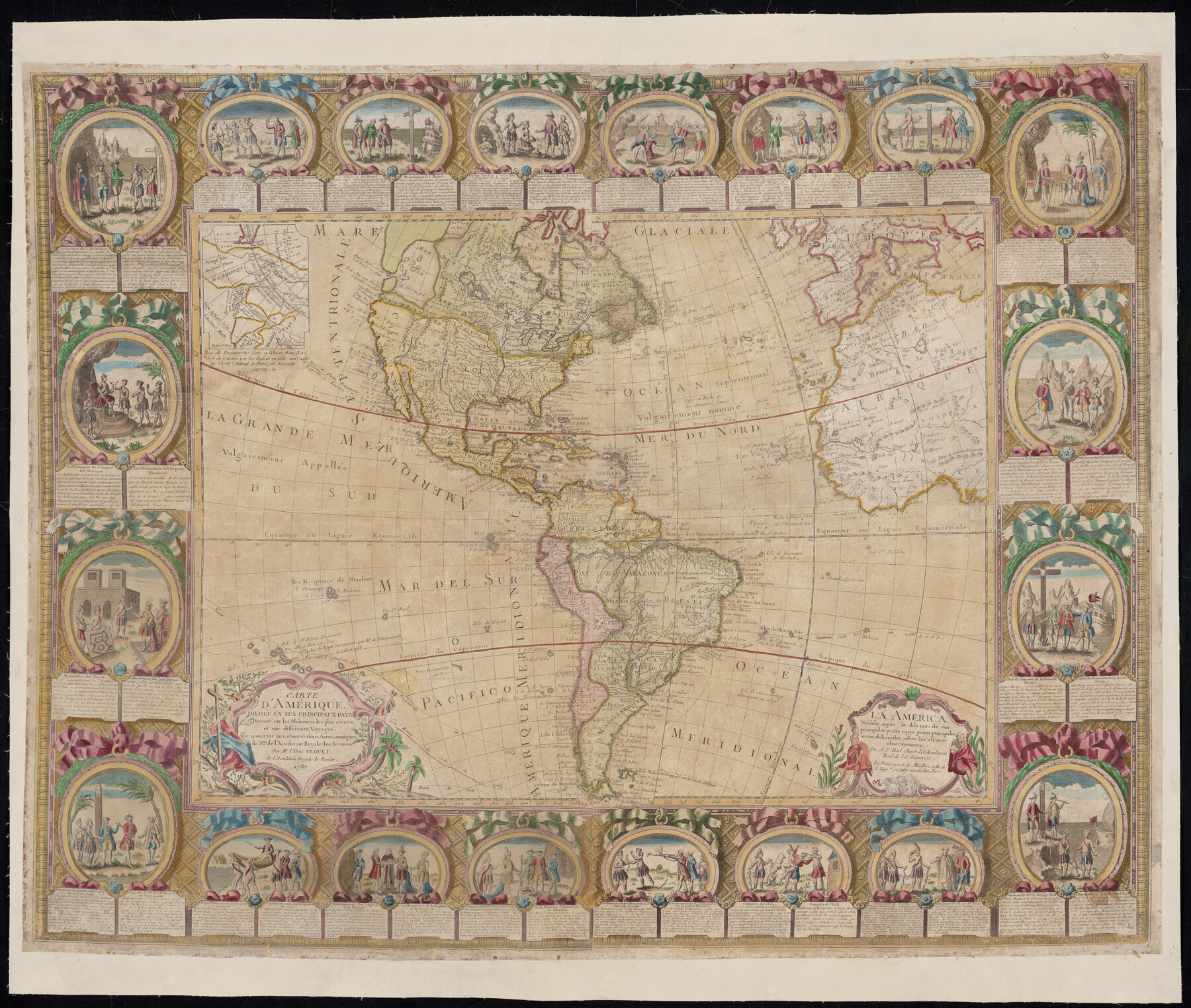
Carte d'Amerique, Divisee en ses Principaux Pays, Dressee sur les Memoires les plus recents, et sur differents Voyages, et assujettie aux observations Astronomiques de Mrs. de l'Academie Royale des Sciences
La America Dividida segun lo dilatado de sus principales partes cuyos puntos principales estan delineados sobre las ultimas observationes
-
Map/Doc
96430
-
Collection
Holcomb Map Collection
-
Object Dates
1787 (Creation Date)
-
People and Organizations
Jean-Baptiste Louis Clouet (Cartographer)
-
Subjects
North America South America
-
Height x Width
43.5 x 51.3 inches
110.5 x 130.3 cm
-
Comments
Courtesy of Frank and Carol Holcomb.
Part of: Holcomb Map Collection
Pressler's Map of Texas

Print $2.00
- Digital $50.00
Pressler's Map of Texas
1867
Size 9.0 x 6.0 inches
Map/Doc 93920
Novissima et Accuratissima Totius Americae Descriptio

Print $20.00
- Digital $50.00
Novissima et Accuratissima Totius Americae Descriptio
1677
Size 20.9 x 25.0 inches
Map/Doc 93819
Texas, Oregon and California [Cover and accompaniment]
![93873, Texas, Oregon and California [Cover and accompaniment], Holcomb Digital Map Collection](https://historictexasmaps.com/wmedia_w700/pdf_converted_jpg/qi_pdf_thumbnail_38543.jpg)
Print $108.00
- Digital $50.00
Texas, Oregon and California [Cover and accompaniment]
1846
Size 5.4 x 3.4 inches
Map/Doc 93873
Map No. 1. Eastern States designed to accompany Smith's Geography for School

Print $20.00
- Digital $50.00
Map No. 1. Eastern States designed to accompany Smith's Geography for School
1850
Size 9.8 x 12.1 inches
Map/Doc 93885
Carta Geografica General de la Republica Mexicana

Print $40.00
- Digital $50.00
Carta Geografica General de la Republica Mexicana
1845
Size 38.1 x 52.9 inches
Map/Doc 96438
Atlas to Accompany the Official Records of the Union and Confederate Armies, 1861-1865

Print $20.00
- Digital $50.00
Atlas to Accompany the Official Records of the Union and Confederate Armies, 1861-1865
Size 18.6 x 29.8 inches
Map/Doc 95412
A Map of the United States including Louisiana

Print $20.00
- Digital $50.00
A Map of the United States including Louisiana
1817
Size 14.9 x 18.2 inches
Map/Doc 95964
America siue India Nova ad magnae Gerardi Mercatoris aui Vniversalis imitationem in compendium redacta

Print $20.00
- Digital $50.00
America siue India Nova ad magnae Gerardi Mercatoris aui Vniversalis imitationem in compendium redacta
1595
Size 18.3 x 21.6 inches
Map/Doc 93807
North America corrected from the observations communicated to the Royal Society at London and the Royal Academy at Paris

Print $20.00
- Digital $50.00
North America corrected from the observations communicated to the Royal Society at London and the Royal Academy at Paris
1710
Size 38.9 x 26.9 inches
Map/Doc 93820
Americae nova Tabula

Print $20.00
- Digital $50.00
Americae nova Tabula
1617
Size 16.0 x 21.5 inches
Map/Doc 93813
Colton's New Map of the State of Texas, the Indian Territory and adjoining portions of New Mexico, Louisiana and Arkansas

Print $20.00
- Digital $50.00
Colton's New Map of the State of Texas, the Indian Territory and adjoining portions of New Mexico, Louisiana and Arkansas
1882
Size 32.8 x 37.3 inches
Map/Doc 93909
Karte des Staates, Texas

Print $20.00
- Digital $50.00
Karte des Staates, Texas
1851
Size 17.8 x 19.9 inches
Map/Doc 97191
You may also like
Atascosa County Boundary File 5

Print $32.00
- Digital $50.00
Atascosa County Boundary File 5
Size 8.8 x 6.3 inches
Map/Doc 50198
Hemphill County

Print $20.00
- Digital $50.00
Hemphill County
1878
Size 19.1 x 16.9 inches
Map/Doc 3661
General Highway Map, Bowie County, Texas

Print $20.00
General Highway Map, Bowie County, Texas
1961
Size 18.2 x 25.0 inches
Map/Doc 79380
Rio Grande, Brownsville Sheet No. 2

Print $4.00
- Digital $50.00
Rio Grande, Brownsville Sheet No. 2
1924
Size 21.2 x 28.3 inches
Map/Doc 65131
Webb County Rolled Sketch 76

Print $20.00
- Digital $50.00
Webb County Rolled Sketch 76
1959
Size 32.8 x 44.0 inches
Map/Doc 10133
Controlled Mosaic by Jack Amman Photogrammetric Engineers, Inc - Sheet 49

Print $20.00
- Digital $50.00
Controlled Mosaic by Jack Amman Photogrammetric Engineers, Inc - Sheet 49
1954
Size 20.0 x 24.0 inches
Map/Doc 83508
Travis County Working Sketch 49

Print $20.00
- Digital $50.00
Travis County Working Sketch 49
1984
Size 33.9 x 37.2 inches
Map/Doc 69433
Township No. 4 South Range No. 19 West of the Indian Meridian

Print $20.00
- Digital $50.00
Township No. 4 South Range No. 19 West of the Indian Meridian
1875
Size 19.1 x 24.5 inches
Map/Doc 75183
Menard County Boundary File 6

Print $6.00
- Digital $50.00
Menard County Boundary File 6
Size 11.2 x 8.7 inches
Map/Doc 57086

Saline Ranch in Mason, Kimble and Menard Counties

Print $20.00
- Digital $50.00
Saline Ranch in Mason, Kimble and Menard Counties
1916
Size 28.3 x 27.2 inches
Map/Doc 75806
