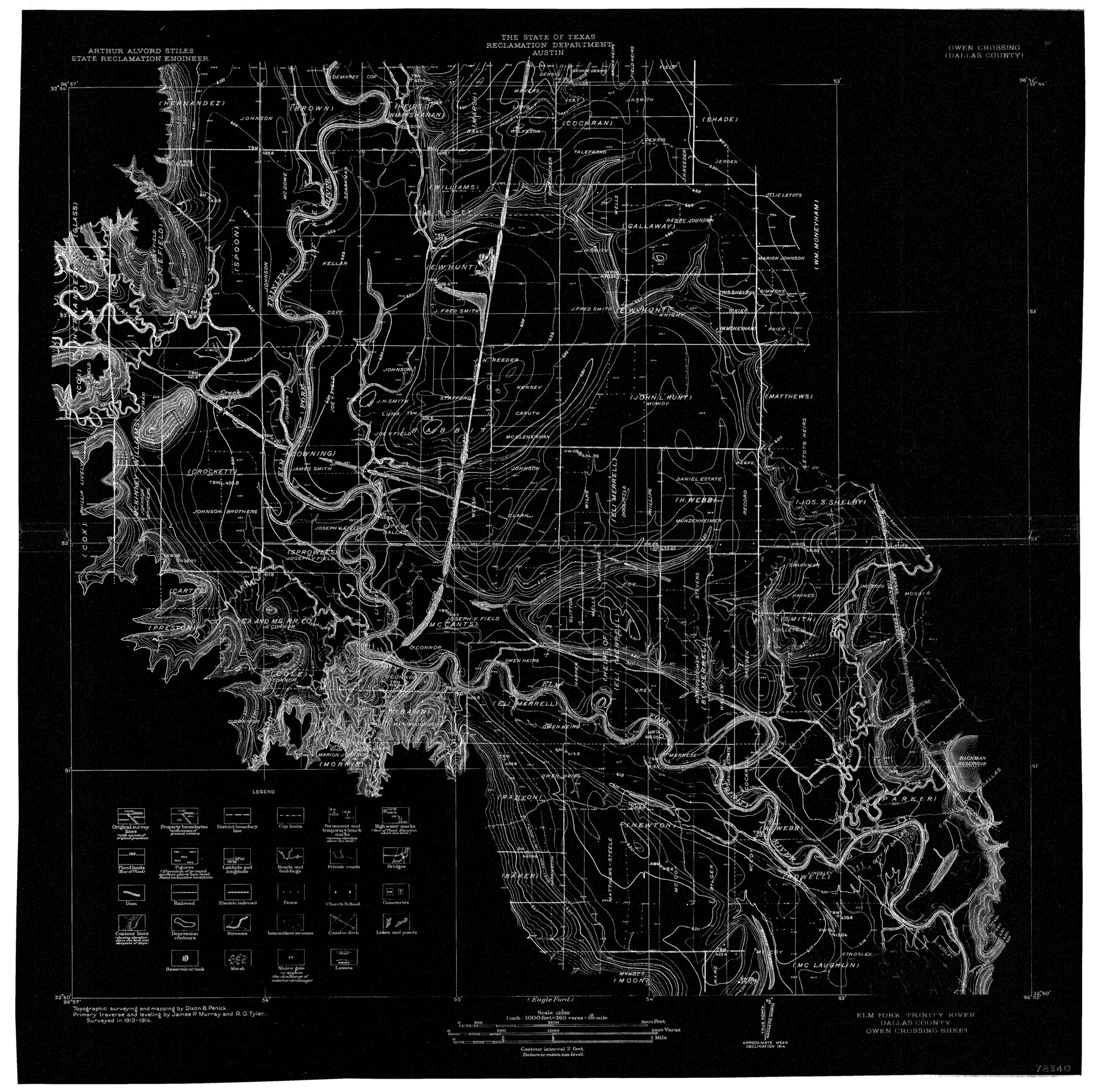
Trinity River, OwenCrossing Sheet/Elm Fork of Trinity River
-
Map/Doc
78340
-
Collection
General Map Collection
-
Object Dates
1914 (Creation Date)
-
People and Organizations
Texas State Reclamation Department (Publisher)
Dixon B. Penick (Surveyor/Engineer)
James P. Murray (Surveyor/Engineer)
R.G. Tyler (Surveyor/Engineer)
-
Counties
Dallas
-
Subjects
River Surveys Topographic
-
Height x Width
29.2 x 29.4 inches
74.2 x 74.7 cm
-
Comments
Owens Crossing Sheet located north of the Eagle Ford Sheet.
Part of: General Map Collection
Lamar County Working Sketch 5

Print $20.00
- Digital $50.00
Lamar County Working Sketch 5
1962
Size 21.5 x 23.6 inches
Map/Doc 70266
Hopkins County

Print $20.00
- Digital $50.00
Hopkins County
1942
Size 45.7 x 42.2 inches
Map/Doc 95533
Refugio County Sketch File 10

Print $4.00
- Digital $50.00
Refugio County Sketch File 10
Size 8.2 x 9.4 inches
Map/Doc 35258
Flight Mission No. DCL-7C, Frame 61, Kenedy County

Print $20.00
- Digital $50.00
Flight Mission No. DCL-7C, Frame 61, Kenedy County
1943
Size 15.4 x 15.2 inches
Map/Doc 86049
Map of Great Britain and Ireland engraved to illustrate Mitchell's new intermediate geography

Print $20.00
- Digital $50.00
Map of Great Britain and Ireland engraved to illustrate Mitchell's new intermediate geography
1885
Size 12.2 x 9.0 inches
Map/Doc 93527
Martin County Working Sketch 14

Print $20.00
- Digital $50.00
Martin County Working Sketch 14
1972
Size 39.6 x 22.6 inches
Map/Doc 70832
Map of Neches River, Texas from Sabine Lake to Beaumont, Texas

Print $40.00
- Digital $50.00
Map of Neches River, Texas from Sabine Lake to Beaumont, Texas
1910
Size 32.4 x 104.0 inches
Map/Doc 2465
Right of Way and Track Map Texas & New Orleans R.R. Co. operated by the T. & N. O. R.R. Co. Dallas-Sabine Branch

Print $40.00
- Digital $50.00
Right of Way and Track Map Texas & New Orleans R.R. Co. operated by the T. & N. O. R.R. Co. Dallas-Sabine Branch
1918
Size 26.4 x 56.7 inches
Map/Doc 64154
Uvalde County Sketch File 7

Print $6.00
- Digital $50.00
Uvalde County Sketch File 7
Size 14.5 x 11.4 inches
Map/Doc 38962
Dallas County Working Sketch 5

Print $20.00
- Digital $50.00
Dallas County Working Sketch 5
1941
Size 18.7 x 16.4 inches
Map/Doc 68571
Flight Mission No. BRA-9M, Frame 61, Jefferson County

Print $20.00
- Digital $50.00
Flight Mission No. BRA-9M, Frame 61, Jefferson County
1953
Size 18.7 x 22.4 inches
Map/Doc 85644
Culberson County Rolled Sketch 35

Print $20.00
- Digital $50.00
Culberson County Rolled Sketch 35
1934
Size 19.1 x 10.9 inches
Map/Doc 5659
You may also like
Section O Tech Memorial Park, Inc.

Print $20.00
- Digital $50.00
Section O Tech Memorial Park, Inc.
1950
Size 17.2 x 19.2 inches
Map/Doc 92299
Sabine County Working Sketch 15

Print $20.00
- Digital $50.00
Sabine County Working Sketch 15
1957
Size 21.2 x 34.9 inches
Map/Doc 63686
Cass County Working Sketch 53

Print $20.00
- Digital $50.00
Cass County Working Sketch 53
2007
Size 30.2 x 36.0 inches
Map/Doc 88608
Flight Mission No. BRA-7M, Frame 135, Jefferson County

Print $20.00
- Digital $50.00
Flight Mission No. BRA-7M, Frame 135, Jefferson County
1953
Size 18.6 x 22.4 inches
Map/Doc 85529
Map of Harrison County, Texas

Print $20.00
- Digital $50.00
Map of Harrison County, Texas
1879
Size 20.2 x 21.9 inches
Map/Doc 375
Railroad Track Map, H&TCRRCo., Falls County, Texas

Print $4.00
- Digital $50.00
Railroad Track Map, H&TCRRCo., Falls County, Texas
1918
Size 11.5 x 18.5 inches
Map/Doc 62856
The Texas and Pacific Ry. Co., Station Map, Loraine, Texas

Print $20.00
- Digital $50.00
The Texas and Pacific Ry. Co., Station Map, Loraine, Texas
Size 11.6 x 18.6 inches
Map/Doc 64683
Jasper County Sketch File 27

Print $22.00
- Digital $50.00
Jasper County Sketch File 27
Size 11.4 x 8.8 inches
Map/Doc 27842
Galveston County NRC Article 33.136 Sketch 18

Print $66.00
- Digital $50.00
Galveston County NRC Article 33.136 Sketch 18
2003
Size 22.4 x 33.9 inches
Map/Doc 78545
Somervell County Rolled Sketch A

Print $20.00
- Digital $50.00
Somervell County Rolled Sketch A
Size 14.8 x 15.2 inches
Map/Doc 75999
McCulloch County Boundary File 64

Print $36.00
- Digital $50.00
McCulloch County Boundary File 64
Size 9.2 x 8.9 inches
Map/Doc 56919
