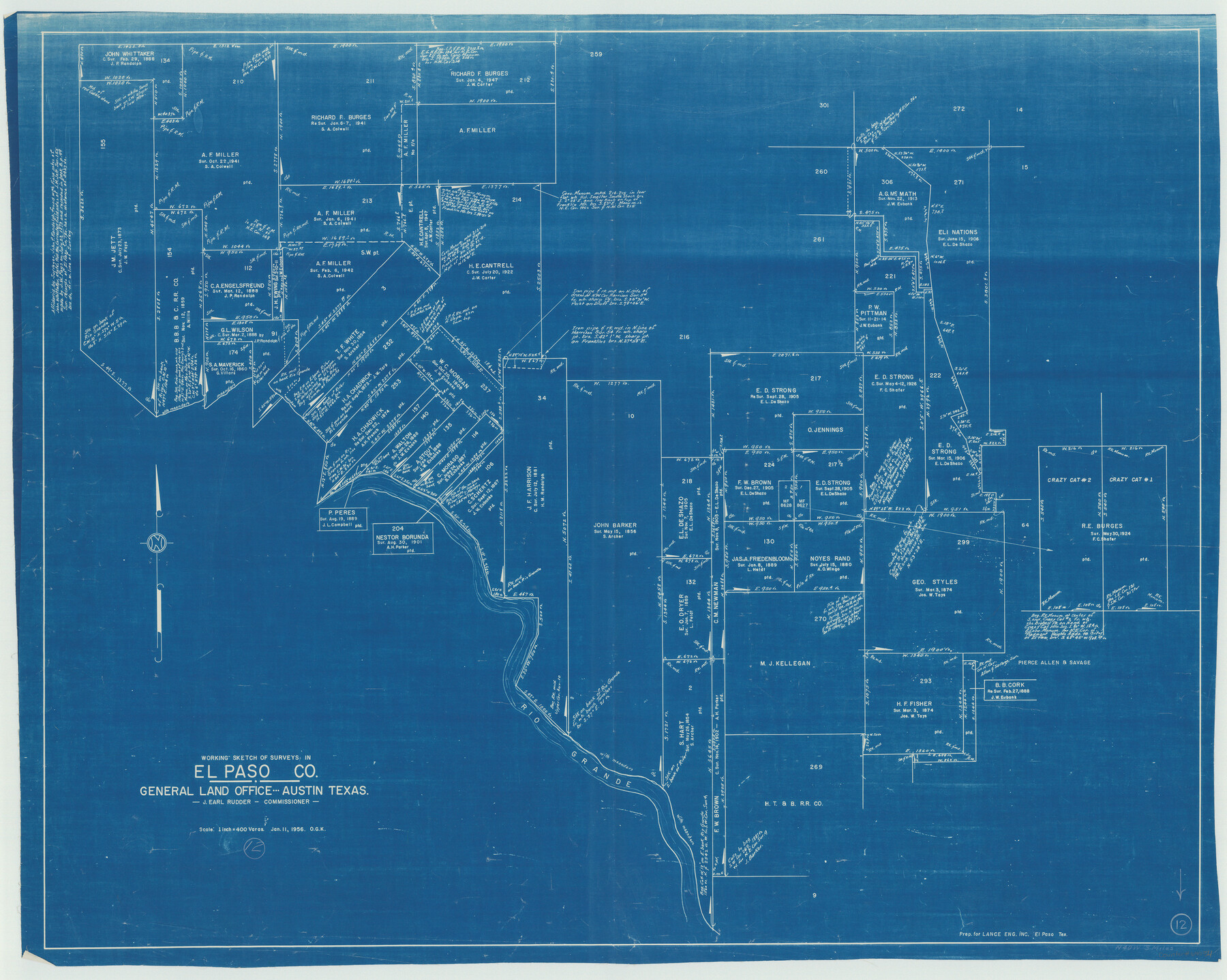
El Paso County Working Sketch 12
-
Map/Doc
69034
-
Collection
General Map Collection
-
Object Dates
1/11/1956 (Creation Date)
-
People and Organizations
Otto G. Kurio (Draftsman)
-
Counties
El Paso
-
Subjects
Surveying Working Sketch
-
Height x Width
33.0 x 41.4 inches
83.8 x 105.2 cm
-
Scale
1" = 400 varas
Part of: General Map Collection
Travis County Sketch File 51

Print $8.00
- Digital $50.00
Travis County Sketch File 51
1941
Size 14.3 x 8.9 inches
Map/Doc 38387

Palo Pinto County Boundary File 4

Print $17.00
- Digital $50.00
Palo Pinto County Boundary File 4
Size 9.0 x 8.4 inches
Map/Doc 57811
Karnes County Working Sketch 5

Print $20.00
- Digital $50.00
Karnes County Working Sketch 5
1960
Size 37.2 x 36.8 inches
Map/Doc 66653
Gaines County Working Sketch 3

Print $20.00
- Digital $50.00
Gaines County Working Sketch 3
1939
Size 45.6 x 43.8 inches
Map/Doc 69303
Edwards County Working Sketch 121

Print $20.00
- Digital $50.00
Edwards County Working Sketch 121
1976
Size 28.2 x 24.8 inches
Map/Doc 68997
Starr County Sketch File 12

Print $20.00
- Digital $50.00
Starr County Sketch File 12
1886
Size 16.2 x 23.7 inches
Map/Doc 12328
Brewster County Rolled Sketch 91

Print $20.00
- Digital $50.00
Brewster County Rolled Sketch 91
1949
Size 27.5 x 15.3 inches
Map/Doc 5249
Shackelford County Working Sketch 6

Print $20.00
- Digital $50.00
Shackelford County Working Sketch 6
1963
Size 26.1 x 28.9 inches
Map/Doc 63846
Flight Mission No. BQR-9K, Frame 13, Brazoria County

Print $20.00
- Digital $50.00
Flight Mission No. BQR-9K, Frame 13, Brazoria County
1952
Size 19.0 x 22.6 inches
Map/Doc 84042
[Copy of a portion of] The Coast & Bays of Western Texas, St. Joseph's and Mustang Islands from Actual Survey, the Remainder from County Maps, Etc.
![72769, [Copy of a portion of] The Coast & Bays of Western Texas, St. Joseph's and Mustang Islands from Actual Survey, the Remainder from County Maps, Etc., General Map Collection](https://historictexasmaps.com/wmedia_w700/maps/72769.tif.jpg)
Print $20.00
- Digital $50.00
[Copy of a portion of] The Coast & Bays of Western Texas, St. Joseph's and Mustang Islands from Actual Survey, the Remainder from County Maps, Etc.
1857
Size 25.9 x 18.3 inches
Map/Doc 72769
Morris County Rolled Sketch 2A

Print $20.00
- Digital $50.00
Morris County Rolled Sketch 2A
Size 24.0 x 18.7 inches
Map/Doc 10287
You may also like
Map of Jefferson County

Print $20.00
- Digital $50.00
Map of Jefferson County
1896
Size 26.7 x 23.2 inches
Map/Doc 66883
Oldham County Sketch File 11

Print $26.00
- Digital $50.00
Oldham County Sketch File 11
Size 13.0 x 8.5 inches
Map/Doc 33247
Live Oak County Working Sketch 9

Print $20.00
- Digital $50.00
Live Oak County Working Sketch 9
1938
Size 35.7 x 41.1 inches
Map/Doc 70594
Montgomery County Working Sketch 15

Print $40.00
- Digital $50.00
Montgomery County Working Sketch 15
1934
Size 51.8 x 41.6 inches
Map/Doc 71122
General Land Office and State Reclamation Department - An Index Map

Print $20.00
- Digital $50.00
General Land Office and State Reclamation Department - An Index Map
1930
Size 26.2 x 16.6 inches
Map/Doc 65069
Brewster County Working Sketch 58

Print $20.00
- Digital $50.00
Brewster County Working Sketch 58
1955
Size 19.8 x 21.7 inches
Map/Doc 67659
DeWitt County Rolled Sketch 3A

Print $20.00
- Digital $50.00
DeWitt County Rolled Sketch 3A
1950
Size 25.3 x 35.2 inches
Map/Doc 5704
Polk County Sketch File 3

Print $10.00
- Digital $50.00
Polk County Sketch File 3
1848
Size 8.5 x 7.6 inches
Map/Doc 34122
Val Verde County Working Sketch 117

Print $20.00
- Digital $50.00
Val Verde County Working Sketch 117
1993
Size 20.8 x 36.8 inches
Map/Doc 82845
Young County Rolled Sketch 2

Print $20.00
- Digital $50.00
Young County Rolled Sketch 2
Size 26.2 x 25.0 inches
Map/Doc 8292
Presidio County Working Sketch 27

Print $20.00
- Digital $50.00
Presidio County Working Sketch 27
1945
Size 32.4 x 13.4 inches
Map/Doc 71703
Panola County Working Sketch 33

Print $40.00
- Digital $50.00
Panola County Working Sketch 33
1983
Map/Doc 71442