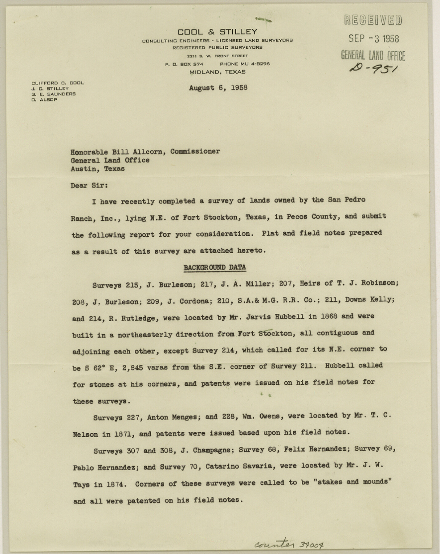
Pecos County Sketch File 99
[Surveyor's report regarding SF-15974 and surveys northeast from Ft. Stockton]
-
Map/Doc
34004
-
Collection
General Map Collection
-
Object Dates
1958/9/3 (File Date)
1958/8/6 (Correspondence Date)
-
People and Organizations
Clifford C. Cool (Surveyor/Engineer)
Jarvis Hubbell (Surveyor/Engineer)
J.W. Tays (Surveyor/Engineer)
T.C. Nelson (Surveyor/Engineer)
L.W. Durrell (Surveyor/Engineer)
O.W. Williams (Surveyor/Engineer)
-
Counties
Pecos
-
Subjects
Surveying Sketch File
-
Height x Width
11.2 x 8.8 inches
28.4 x 22.4 cm
-
Medium
paper, print
-
Comments
See Pecos County Rolled Sketch 149 (9735) for sketch.
-
Features
Fort Stockton
Camp Van Camp
Related maps
Pecos County Rolled Sketch 149

Print $20.00
- Digital $50.00
Pecos County Rolled Sketch 149
1958
Size 36.0 x 38.5 inches
Map/Doc 9735
Part of: General Map Collection
Flight Mission No. CGN-3P, Frame 22, San Patricio County

Print $20.00
- Digital $50.00
Flight Mission No. CGN-3P, Frame 22, San Patricio County
1956
Size 18.6 x 22.3 inches
Map/Doc 86980
Burnet County Rolled Sketch D1

Print $20.00
- Digital $50.00
Burnet County Rolled Sketch D1
1924
Size 22.2 x 18.5 inches
Map/Doc 5358
Pecos County Working Sketch 87

Print $20.00
- Digital $50.00
Pecos County Working Sketch 87
1962
Size 29.0 x 31.6 inches
Map/Doc 71559
Flight Mission No. CGI-4N, Frame 161, Cameron County

Print $20.00
- Digital $50.00
Flight Mission No. CGI-4N, Frame 161, Cameron County
1955
Size 18.7 x 22.4 inches
Map/Doc 84669
Kleberg County Rolled Sketch 10-43

Print $20.00
- Digital $50.00
Kleberg County Rolled Sketch 10-43
1951
Size 37.2 x 34.9 inches
Map/Doc 9395
Coke County Working Sketch 21

Print $20.00
- Digital $50.00
Coke County Working Sketch 21
1949
Size 22.9 x 29.4 inches
Map/Doc 68058
Polk County Working Sketch 11

Print $20.00
- Digital $50.00
Polk County Working Sketch 11
1940
Size 29.3 x 28.6 inches
Map/Doc 71626
Railroad Track Map, H&TCRRCo., Falls County, Texas

Print $4.00
- Digital $50.00
Railroad Track Map, H&TCRRCo., Falls County, Texas
1918
Size 11.8 x 18.6 inches
Map/Doc 62844
San Augustine County Working Sketch 5

Print $20.00
- Digital $50.00
San Augustine County Working Sketch 5
1935
Size 39.0 x 37.4 inches
Map/Doc 63692
Van Zandt County Sketch File 22

Print $6.00
- Digital $50.00
Van Zandt County Sketch File 22
Size 8.6 x 7.8 inches
Map/Doc 39432
Pecos County Rolled Sketch 176

Print $20.00
- Digital $50.00
Pecos County Rolled Sketch 176
1978
Size 14.1 x 33.6 inches
Map/Doc 7296
Frio County Sketch File 11

Print $4.00
- Digital $50.00
Frio County Sketch File 11
1912
Size 8.4 x 11.2 inches
Map/Doc 23125
You may also like
Flight Mission No. CRK-3P, Frame 175, Refugio County

Print $20.00
- Digital $50.00
Flight Mission No. CRK-3P, Frame 175, Refugio County
1956
Size 18.6 x 21.7 inches
Map/Doc 86922
Aransas Pass to Baffin Bay

Print $20.00
- Digital $50.00
Aransas Pass to Baffin Bay
1981
Size 43.0 x 35.0 inches
Map/Doc 73420
Map of Lavaca County
Print $20.00
- Digital $50.00
Map of Lavaca County
1866
Size 22.3 x 23.7 inches
Map/Doc 3802
Cameron County Rolled Sketch 19

Print $20.00
- Digital $50.00
Cameron County Rolled Sketch 19
Size 25.8 x 23.6 inches
Map/Doc 5465
Crockett County Rolled Sketch 37

Print $20.00
- Digital $50.00
Crockett County Rolled Sketch 37
Size 36.7 x 29.3 inches
Map/Doc 5589
Liberty County Working Sketch 61

Print $20.00
- Digital $50.00
Liberty County Working Sketch 61
1969
Size 43.3 x 32.0 inches
Map/Doc 70521
Leon County, Texas

Print $20.00
- Digital $50.00
Leon County, Texas
1879
Size 25.6 x 22.3 inches
Map/Doc 563
General Highway Map, Jasper County, Texas

Print $20.00
General Highway Map, Jasper County, Texas
1961
Size 18.3 x 24.7 inches
Map/Doc 79535
Hopkins County Boundary File 2

Print $4.00
- Digital $50.00
Hopkins County Boundary File 2
Size 12.5 x 8.1 inches
Map/Doc 55057
Morris County Working Sketch 6

Print $20.00
- Digital $50.00
Morris County Working Sketch 6
1985
Size 35.8 x 36.7 inches
Map/Doc 71205
Houston County Working Sketch 21

Print $20.00
- Digital $50.00
Houston County Working Sketch 21
1981
Size 26.6 x 39.6 inches
Map/Doc 66251
Survey of Lots 1, 2, 3, 4 and 5, Block 12G Fair View Park, Austin Texas

Print $20.00
- Digital $50.00
Survey of Lots 1, 2, 3, 4 and 5, Block 12G Fair View Park, Austin Texas
1914
Size 10.7 x 22.8 inches
Map/Doc 472