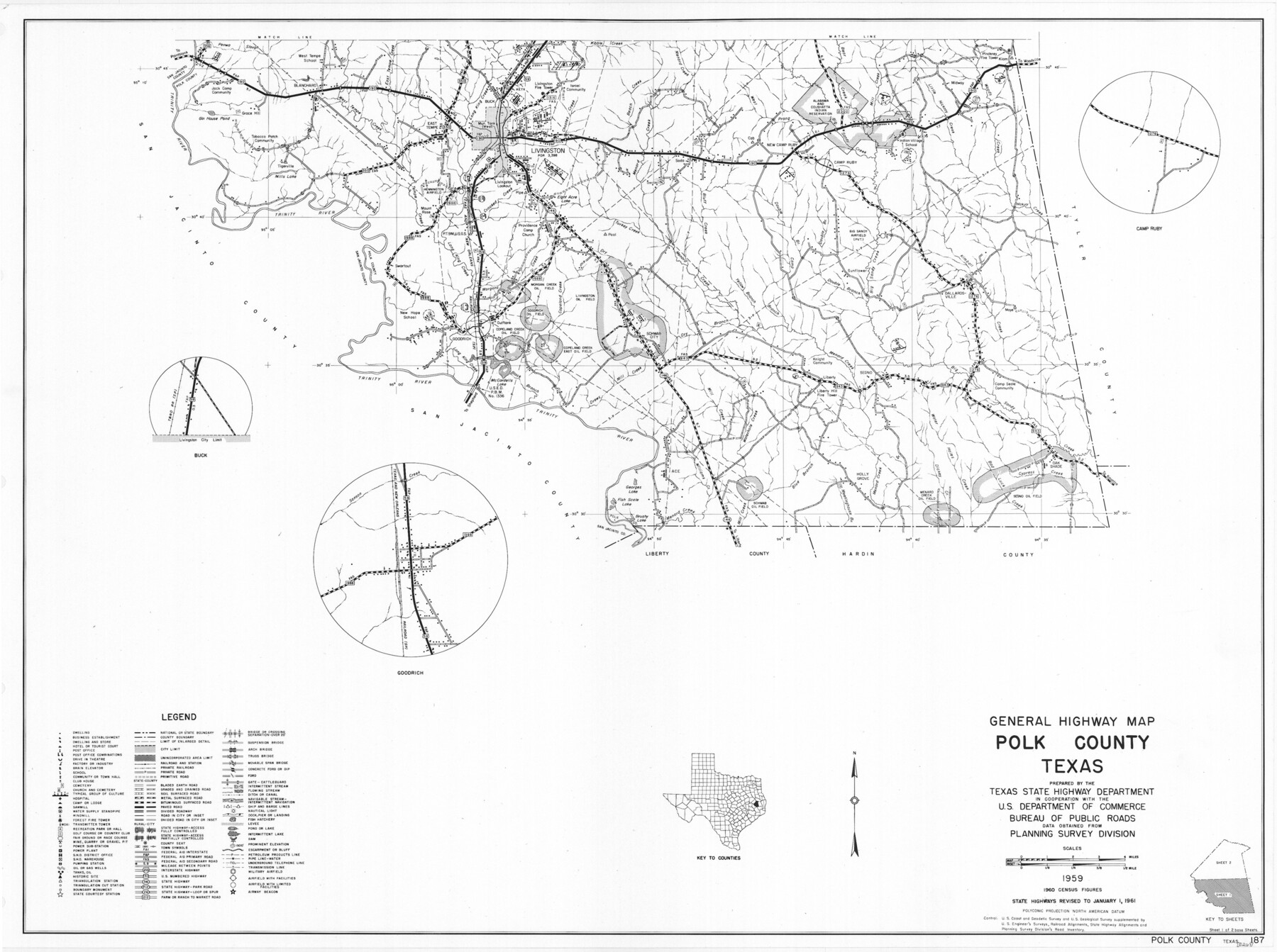
General Highway Map, Polk County, Texas
-
Map/Doc
79629
-
Collection
Texas State Library and Archives
-
Object Dates
1961 (Creation Date)
-
People and Organizations
Texas State Highway Department (Publisher)
-
Counties
Polk
-
Subjects
County
-
Height x Width
18.2 x 24.4 inches
46.2 x 62.0 cm
-
Comments
Prints available courtesy of the Texas State Library and Archives.
More info can be found here: TSLAC Map 05267
Part of: Texas State Library and Archives
General Highway Map, Blanco County, Texas

Print $20.00
General Highway Map, Blanco County, Texas
1961
Size 25.0 x 18.2 inches
Map/Doc 79376
General Highway Map, Franklin County, Morris County, Titus County, Camp County

Print $20.00
General Highway Map, Franklin County, Morris County, Titus County, Camp County
1940
Size 18.4 x 25.1 inches
Map/Doc 79040
General Highway Map, Hockley County, Texas

Print $20.00
General Highway Map, Hockley County, Texas
1961
Size 18.2 x 24.6 inches
Map/Doc 79522
General Highway Map, Sabine County, Texas

Print $20.00
General Highway Map, Sabine County, Texas
1940
Size 24.9 x 18.4 inches
Map/Doc 79234
General Highway Map, Kinney County, Uvalde County, Texas

Print $20.00
General Highway Map, Kinney County, Uvalde County, Texas
1940
Size 18.4 x 24.8 inches
Map/Doc 79162
General Highway Map. Detail of Cities and Towns in Tarrant County, Texas. City Map, Fort Worth and vicinity, Tarrant County, Texas

Print $20.00
General Highway Map. Detail of Cities and Towns in Tarrant County, Texas. City Map, Fort Worth and vicinity, Tarrant County, Texas
1961
Size 18.1 x 25.0 inches
Map/Doc 79665
General Highway Map, Cochran County, Texas

Print $20.00
General Highway Map, Cochran County, Texas
1961
Size 24.8 x 18.2 inches
Map/Doc 79410
Town of Beaumont in Jefferson County, Texas

Print $20.00
Town of Beaumont in Jefferson County, Texas
1850
Size 17.6 x 24.3 inches
Map/Doc 76267
General Highway Map, Wheeler County, Texas

Print $20.00
General Highway Map, Wheeler County, Texas
1961
Size 18.1 x 24.9 inches
Map/Doc 79708
General Highway Map, Tom Green County, Texas

Print $20.00
General Highway Map, Tom Green County, Texas
1961
Size 18.4 x 25.0 inches
Map/Doc 79678
General Highway Map, Carson County, Texas

Print $20.00
General Highway Map, Carson County, Texas
1961
Size 18.2 x 24.9 inches
Map/Doc 79401
General Highway Map. Detail of Cities and Towns in Harris County, Texas

Print $20.00
General Highway Map. Detail of Cities and Towns in Harris County, Texas
1961
Size 18.2 x 24.6 inches
Map/Doc 79503
You may also like
Stonewall County Working Sketch 34

Print $20.00
- Digital $50.00
Stonewall County Working Sketch 34
1985
Size 34.0 x 33.9 inches
Map/Doc 62341
Grimes County Working Sketch 1

Print $20.00
- Digital $50.00
Grimes County Working Sketch 1
1920
Size 33.1 x 30.7 inches
Map/Doc 63292
Morris County Rolled Sketch 2A

Print $20.00
- Digital $50.00
Morris County Rolled Sketch 2A
Size 24.3 x 19.1 inches
Map/Doc 10242
Flight Mission No. DQO-11K, Frame 27, Galveston County

Print $20.00
- Digital $50.00
Flight Mission No. DQO-11K, Frame 27, Galveston County
1952
Size 18.8 x 22.4 inches
Map/Doc 85224
Flight Mission No. BRA-7M, Frame 82, Jefferson County

Print $20.00
- Digital $50.00
Flight Mission No. BRA-7M, Frame 82, Jefferson County
1953
Size 16.1 x 15.9 inches
Map/Doc 85504
Uvalde County Sketch File 13

Print $20.00
- Digital $50.00
Uvalde County Sketch File 13
Size 14.3 x 29.1 inches
Map/Doc 12528
Frio County Sketch File A

Print $40.00
- Digital $50.00
Frio County Sketch File A
1878
Size 16.4 x 13.4 inches
Map/Doc 23099
Zapata County Sketch File 4

Print $22.00
- Digital $50.00
Zapata County Sketch File 4
1892
Size 14.5 x 17.5 inches
Map/Doc 40906
Central Plains 'Holiness' College Grounds

Print $20.00
- Digital $50.00
Central Plains 'Holiness' College Grounds
1906
Size 17.2 x 30.8 inches
Map/Doc 92124
Central Part of Jeff Davis Co.

Print $40.00
- Digital $50.00
Central Part of Jeff Davis Co.
1982
Size 56.3 x 43.9 inches
Map/Doc 95543
San Patricio County Rolled Sketch 31

Print $20.00
- Digital $50.00
San Patricio County Rolled Sketch 31
1941
Size 43.1 x 42.6 inches
Map/Doc 9898
Gregg County Sketch File 1F

Print $4.00
- Digital $50.00
Gregg County Sketch File 1F
1850
Size 12.2 x 7.8 inches
Map/Doc 24547