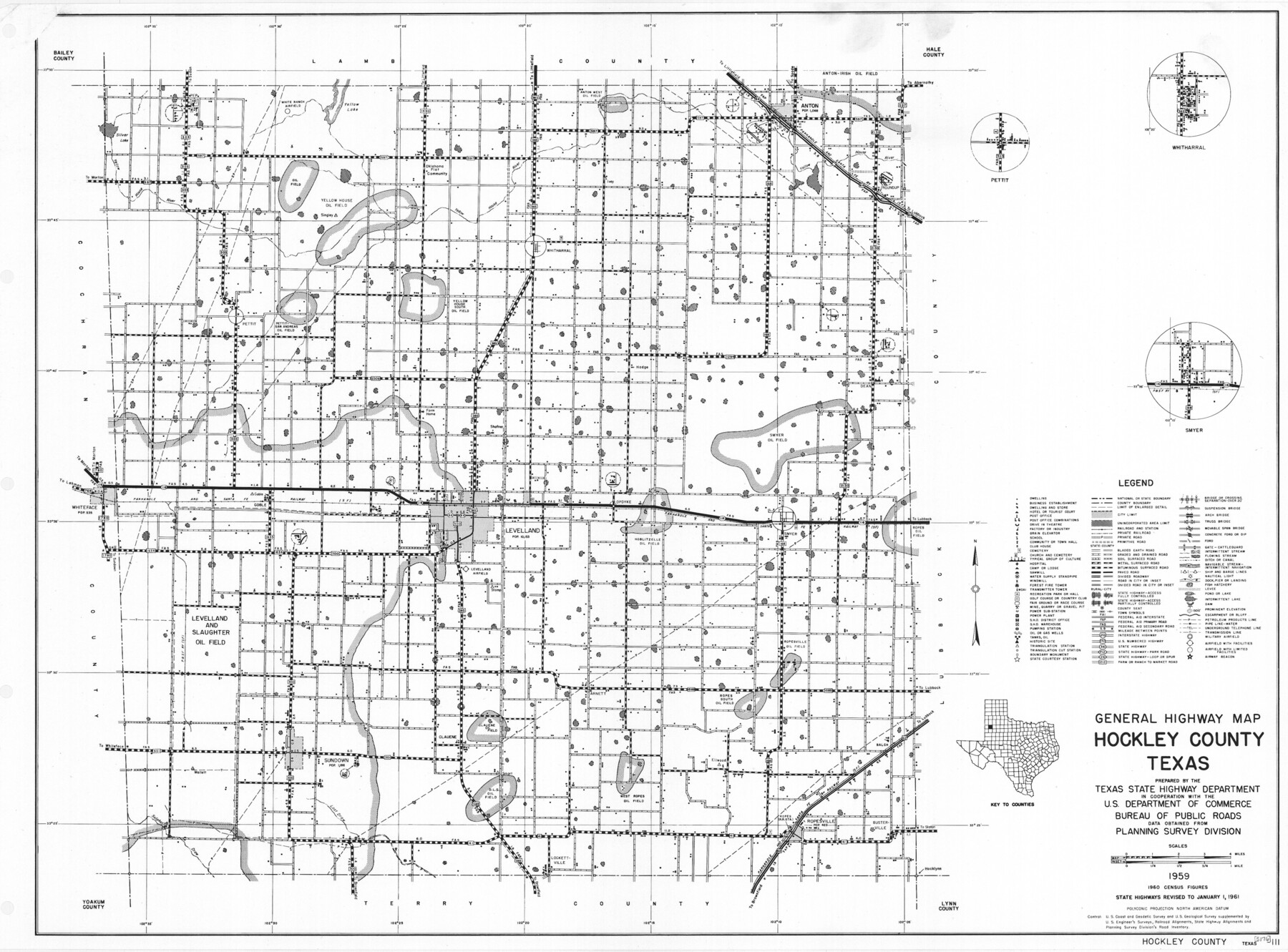
General Highway Map, Hockley County, Texas
-
Map/Doc
79522
-
Collection
Texas State Library and Archives
-
Object Dates
1961 (Creation Date)
-
People and Organizations
Texas State Highway Department (Publisher)
-
Counties
Hockley
-
Subjects
County
-
Height x Width
18.2 x 24.6 inches
46.2 x 62.5 cm
-
Comments
Prints available courtesy of the Texas State Library and Archives.
More info can be found here: TSLAC Map 05176
Part of: Texas State Library and Archives
Topographic Map of Big Bend Area

Print $20.00
Topographic Map of Big Bend Area
1923
Size 47.1 x 35.0 inches
Map/Doc 79757
General Highway Map, Freestone County, Texas

Print $20.00
General Highway Map, Freestone County, Texas
1961
Size 18.1 x 24.8 inches
Map/Doc 79472
General Soil Map of Texas

Print $20.00
General Soil Map of Texas
1935
Size 35.2 x 46.4 inches
Map/Doc 76309
A Map of Louisiana and Mexico

Print $20.00
A Map of Louisiana and Mexico
1820
Size 43.0 x 32.6 inches
Map/Doc 76218
General Highway Map, Bowie County, Texas

Print $20.00
General Highway Map, Bowie County, Texas
1961
Size 18.2 x 25.0 inches
Map/Doc 79380
General Highway Map, Winkler County, Texas

Print $20.00
General Highway Map, Winkler County, Texas
1961
Size 18.2 x 24.8 inches
Map/Doc 79716
General Highway Map, Matagorda County, Texas

Print $20.00
General Highway Map, Matagorda County, Texas
1961
Size 24.8 x 18.2 inches
Map/Doc 79585
General Highway Map. Detail of Cities and Towns in Milam County, Texas [Rockdale and Cameron and vicinities]
![79598, General Highway Map. Detail of Cities and Towns in Milam County, Texas [Rockdale and Cameron and vicinities], Texas State Library and Archives](https://historictexasmaps.com/wmedia_w700/maps/79598.tif.jpg)
Print $20.00
General Highway Map. Detail of Cities and Towns in Milam County, Texas [Rockdale and Cameron and vicinities]
1961
Size 18.1 x 24.6 inches
Map/Doc 79598
Railroad and County Map of Texas

Print $20.00
Railroad and County Map of Texas
1893
Size 24.2 x 27.2 inches
Map/Doc 76255
General Highway Map, Liberty County, Texas

Print $20.00
General Highway Map, Liberty County, Texas
1961
Size 18.2 x 24.7 inches
Map/Doc 79570
General Highway Map. Detail of Cities and Towns in Galveston County, Texas. City Map of Galveston and vicinity, Galveston County, Texas

Print $20.00
General Highway Map. Detail of Cities and Towns in Galveston County, Texas. City Map of Galveston and vicinity, Galveston County, Texas
1961
Size 18.1 x 24.6 inches
Map/Doc 79477
General Highway Map. Detail of Cities and Towns in Harris County, Texas

Print $20.00
General Highway Map. Detail of Cities and Towns in Harris County, Texas
1939
Size 18.5 x 24.7 inches
Map/Doc 79118
You may also like
Flight Mission No. DAH-9M, Frame 163, Orange County

Print $20.00
- Digital $50.00
Flight Mission No. DAH-9M, Frame 163, Orange County
1953
Size 18.4 x 22.4 inches
Map/Doc 86862
Presidio County Sketch File K

Print $8.00
- Digital $50.00
Presidio County Sketch File K
1907
Size 13.6 x 8.6 inches
Map/Doc 34456
Bastrop County Sketch File 9

Print $40.00
- Digital $50.00
Bastrop County Sketch File 9
1943
Size 46.5 x 20.6 inches
Map/Doc 10320
San Patricio County Rolled Sketch 20A

Print $20.00
- Digital $50.00
San Patricio County Rolled Sketch 20A
Size 25.9 x 30.3 inches
Map/Doc 7579
Culberson County Working Sketch 62

Print $20.00
- Digital $50.00
Culberson County Working Sketch 62
1975
Size 32.2 x 24.6 inches
Map/Doc 68516
Dickens County

Print $20.00
- Digital $50.00
Dickens County
1891
Size 24.5 x 20.2 inches
Map/Doc 4533
Atascosa County Working Sketch 22

Print $20.00
- Digital $50.00
Atascosa County Working Sketch 22
1956
Size 31.6 x 25.5 inches
Map/Doc 67218
Maverick County Working Sketch 12

Print $20.00
- Digital $50.00
Maverick County Working Sketch 12
1965
Size 23.6 x 22.4 inches
Map/Doc 70904
Map of Texas Before Admission to the Union and Adjoining State with Northern Portions of the Mexican States of Coahulia & Chihuahua

Print $20.00
- Digital $50.00
Map of Texas Before Admission to the Union and Adjoining State with Northern Portions of the Mexican States of Coahulia & Chihuahua
1834
Size 18.8 x 21.2 inches
Map/Doc 2107
Childress County Sketch File 1

Print $16.00
- Digital $50.00
Childress County Sketch File 1
1877
Size 12.8 x 8.3 inches
Map/Doc 18235
Gulf Coast of the United States, Key West to Rio Grande

Print $20.00
- Digital $50.00
Gulf Coast of the United States, Key West to Rio Grande
1863
Size 27.3 x 18.2 inches
Map/Doc 72663
Lampasas County Boundary File 4a

Print $12.00
- Digital $50.00
Lampasas County Boundary File 4a
Size 12.8 x 8.2 inches
Map/Doc 56122