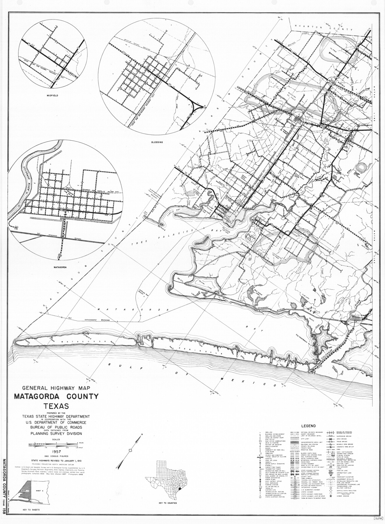
General Highway Map, Matagorda County, Texas
-
Map/Doc
79585
-
Collection
Texas State Library and Archives
-
Object Dates
1961 (Creation Date)
-
People and Organizations
Texas State Highway Department (Publisher)
-
Counties
Matagorda
-
Subjects
County
-
Height x Width
24.8 x 18.2 inches
63.0 x 46.2 cm
-
Comments
Prints available courtesy of the Texas State Library and Archives.
More info can be found here: TSLAC Map 05230
Part of: Texas State Library and Archives
General Highway Map, Zapata County, Texas

Print $20.00
General Highway Map, Zapata County, Texas
1961
Size 18.2 x 24.8 inches
Map/Doc 79721
General Highway Map, Erath County, Texas

Print $20.00
General Highway Map, Erath County, Texas
1940
Size 24.7 x 18.4 inches
Map/Doc 79086
General Highway Map, Sabine County, Texas

Print $20.00
General Highway Map, Sabine County, Texas
1940
Size 24.9 x 18.4 inches
Map/Doc 79234
General Highway Map, Wharton County, Texas

Print $20.00
General Highway Map, Wharton County, Texas
1940
Size 18.5 x 24.9 inches
Map/Doc 79274
General Highway Map, Delta County, Hopkins County, Texas

Print $20.00
General Highway Map, Delta County, Hopkins County, Texas
1961
Size 24.6 x 18.2 inches
Map/Doc 79439
General Highway Map, Ochiltree County, Texas

Print $20.00
General Highway Map, Ochiltree County, Texas
1961
Size 18.2 x 24.3 inches
Map/Doc 79618
General Highway Map, Jones County, Texas

Print $20.00
General Highway Map, Jones County, Texas
1940
Size 18.5 x 24.8 inches
Map/Doc 79150
General Highway Map, Waller County, Texas

Print $20.00
General Highway Map, Waller County, Texas
1939
Size 25.1 x 18.5 inches
Map/Doc 79270
General Highway Map, Moore County, Texas

Print $20.00
General Highway Map, Moore County, Texas
1940
Size 18.4 x 24.8 inches
Map/Doc 79203
General Highway Map, Gray County, Texas

Print $20.00
General Highway Map, Gray County, Texas
1961
Size 18.1 x 24.7 inches
Map/Doc 79483
General Highway Map. Detail of Cities and Towns in Hardin County, Texas [Silsbee and vicinity]
![79500, General Highway Map. Detail of Cities and Towns in Hardin County, Texas [Silsbee and vicinity], Texas State Library and Archives](https://historictexasmaps.com/wmedia_w700/maps/79500.tif.jpg)
Print $20.00
General Highway Map. Detail of Cities and Towns in Hardin County, Texas [Silsbee and vicinity]
1961
Size 18.1 x 24.7 inches
Map/Doc 79500
General Highway Map, Hays County, Texas

Print $20.00
General Highway Map, Hays County, Texas
1961
Size 18.1 x 24.7 inches
Map/Doc 79513
You may also like
Harrison County Working Sketch 10

Print $20.00
- Digital $50.00
Harrison County Working Sketch 10
1957
Size 25.8 x 24.6 inches
Map/Doc 66030
Williamson County

Print $40.00
- Digital $50.00
Williamson County
1888
Size 39.7 x 56.3 inches
Map/Doc 63129
Jack County Working Sketch 19

Print $20.00
- Digital $50.00
Jack County Working Sketch 19
1989
Size 21.5 x 29.4 inches
Map/Doc 66445
Jack County Working Sketch 11

Print $20.00
- Digital $50.00
Jack County Working Sketch 11
1959
Size 23.9 x 23.4 inches
Map/Doc 66437
Anderson County

Print $40.00
- Digital $50.00
Anderson County
1942
Size 54.8 x 48.8 inches
Map/Doc 95415
Reeves County Rolled Sketch 33

Print $20.00
- Digital $50.00
Reeves County Rolled Sketch 33
Size 24.7 x 36.9 inches
Map/Doc 7501
Zapata County Rolled Sketch 22

Print $20.00
- Digital $50.00
Zapata County Rolled Sketch 22
1958
Size 29.2 x 21.5 inches
Map/Doc 8317
Flight Mission No. DCL-6C, Frame 69, Kenedy County

Print $20.00
- Digital $50.00
Flight Mission No. DCL-6C, Frame 69, Kenedy County
1943
Size 18.6 x 22.3 inches
Map/Doc 85911
Wise County Working Sketch 19

Print $20.00
- Digital $50.00
Wise County Working Sketch 19
1978
Size 28.6 x 32.5 inches
Map/Doc 72633
Jones County Working Sketch 7

Print $20.00
- Digital $50.00
Jones County Working Sketch 7
1957
Size 30.8 x 12.7 inches
Map/Doc 66645
Panola County Working Sketch 31

Print $20.00
- Digital $50.00
Panola County Working Sketch 31
1981
Map/Doc 71440
Cass County Rolled Sketch 4

Print $20.00
- Digital $50.00
Cass County Rolled Sketch 4
1946
Size 20.2 x 15.1 inches
Map/Doc 5410