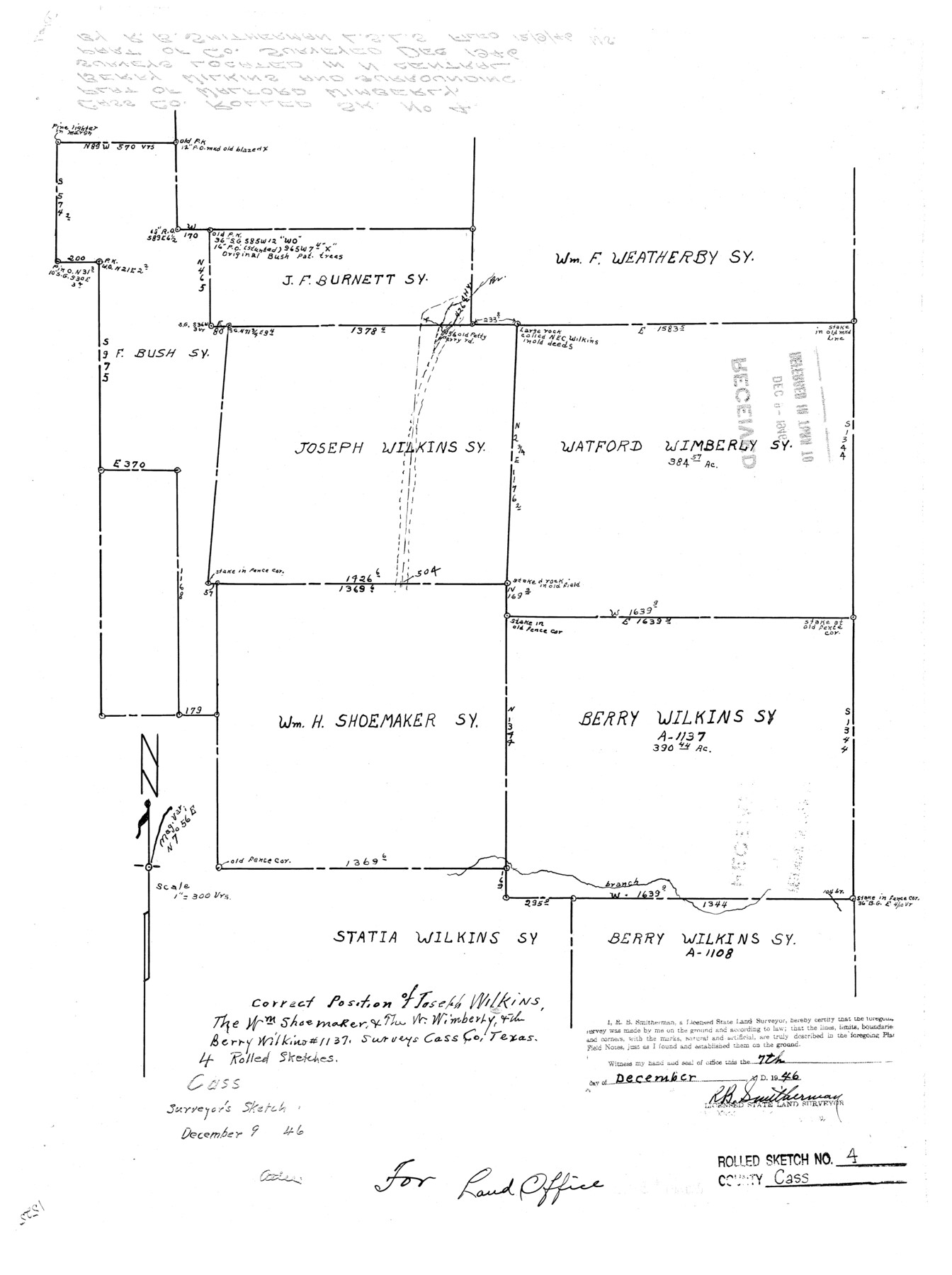
Cass County Rolled Sketch 4
Correct position of Joseph Wilkins, the Wm. Shoemaker, & the W. Wimberly, & the Berry Wilkins #1137 surveys, Cass Co., Texas
-
Map/Doc
5410
-
Collection
General Map Collection
-
Object Dates
1946/12/7 (Creation Date)
1946/12/9 (File Date)
-
People and Organizations
R.B. Smitherman (Surveyor/Engineer)
-
Counties
Cass
-
Subjects
Surveying Rolled Sketch
-
Height x Width
20.2 x 15.1 inches
51.3 x 38.4 cm
-
Scale
1" = 300 varas
Part of: General Map Collection
Gillespie County Rolled Sketch 5

Print $20.00
- Digital $50.00
Gillespie County Rolled Sketch 5
1994
Size 25.7 x 20.6 inches
Map/Doc 6012
Loving County Rolled Sketch 2A

Print $40.00
- Digital $50.00
Loving County Rolled Sketch 2A
1952
Size 41.8 x 71.0 inches
Map/Doc 9463
Red River County Sketch File 28

Print $22.00
- Digital $50.00
Red River County Sketch File 28
1995
Size 11.3 x 8.9 inches
Map/Doc 35165
Nueces County Sketch File 82

Print $4.00
- Digital $50.00
Nueces County Sketch File 82
2000
Size 11.0 x 8.8 inches
Map/Doc 33165
Treaty to Resolve Pending Boundary Differences and Maintain the Rio Grande and Colorado River as the International Boundary Between the United States of American and Mexico

Print $20.00
- Digital $50.00
Treaty to Resolve Pending Boundary Differences and Maintain the Rio Grande and Colorado River as the International Boundary Between the United States of American and Mexico
1970
Size 10.9 x 35.6 inches
Map/Doc 83104
Reeves County Working Sketch 44

Print $20.00
- Digital $50.00
Reeves County Working Sketch 44
1974
Size 46.9 x 32.1 inches
Map/Doc 63487
Presidio County Working Sketch 134

Print $40.00
- Digital $50.00
Presidio County Working Sketch 134
1989
Size 37.0 x 55.6 inches
Map/Doc 71812
Harris County Rolled Sketch 88

Print $20.00
- Digital $50.00
Harris County Rolled Sketch 88
1937
Size 34.8 x 22.8 inches
Map/Doc 6127
San Saba County Sketch File 18

Print $12.00
- Digital $50.00
San Saba County Sketch File 18
1919
Size 11.4 x 8.8 inches
Map/Doc 36460
Hays County Boundary File 1

Print $14.00
- Digital $50.00
Hays County Boundary File 1
Size 9.5 x 5.2 inches
Map/Doc 54586
Flight Mission No. BRA-7M, Frame 13, Jefferson County

Print $20.00
- Digital $50.00
Flight Mission No. BRA-7M, Frame 13, Jefferson County
1953
Size 18.6 x 22.4 inches
Map/Doc 85464
Map of the Lands Surveyed by the Memphis, El Paso & Pacific R.R. Company

Print $20.00
- Digital $50.00
Map of the Lands Surveyed by the Memphis, El Paso & Pacific R.R. Company
1859
Size 19.7 x 23.3 inches
Map/Doc 4847
You may also like
Travis County Working Sketch 42

Print $20.00
- Digital $50.00
Travis County Working Sketch 42
1974
Size 32.5 x 35.2 inches
Map/Doc 69426
Right of Way and Track Map, the Missouri, Kansas and Texas Ry. of Texas - Henrietta Division

Print $20.00
- Digital $50.00
Right of Way and Track Map, the Missouri, Kansas and Texas Ry. of Texas - Henrietta Division
1918
Size 11.8 x 26.8 inches
Map/Doc 64751
Garza County Sketch File J

Print $20.00
- Digital $50.00
Garza County Sketch File J
1911
Size 26.5 x 7.5 inches
Map/Doc 11555
Brewster County Sketch File 45

Print $2.00
- Digital $50.00
Brewster County Sketch File 45
Size 10.7 x 8.2 inches
Map/Doc 16312
Nueces River, Corpus Christi Sheet No. 1-A

Print $6.00
- Digital $50.00
Nueces River, Corpus Christi Sheet No. 1-A
1938
Size 21.9 x 33.2 inches
Map/Doc 65090
Borden County Boundary File 6

Print $28.00
- Digital $50.00
Borden County Boundary File 6
1908
Size 11.3 x 25.1 inches
Map/Doc 1717
Tom Green County Sketch File 15

Print $6.00
- Digital $50.00
Tom Green County Sketch File 15
1880
Size 13.3 x 10.9 inches
Map/Doc 38172
H. W. Stanton's Subdivision of Northeast Quarter, Section 15, Block B

Print $20.00
- Digital $50.00
H. W. Stanton's Subdivision of Northeast Quarter, Section 15, Block B
Size 25.3 x 15.8 inches
Map/Doc 92788
Jim Hogg County Working Sketch 8

Print $40.00
- Digital $50.00
Jim Hogg County Working Sketch 8
1966
Size 82.7 x 40.0 inches
Map/Doc 66594
Flight Mission No. DQO-1K, Frame 20, Galveston County

Print $20.00
- Digital $50.00
Flight Mission No. DQO-1K, Frame 20, Galveston County
1952
Size 19.0 x 22.5 inches
Map/Doc 84979
Galveston County Working Sketch 19

Print $20.00
- Digital $50.00
Galveston County Working Sketch 19
1983
Size 28.7 x 38.6 inches
Map/Doc 69356
Galveston to Rio Grande

Print $20.00
- Digital $50.00
Galveston to Rio Grande
1973
Size 44.2 x 36.8 inches
Map/Doc 69956