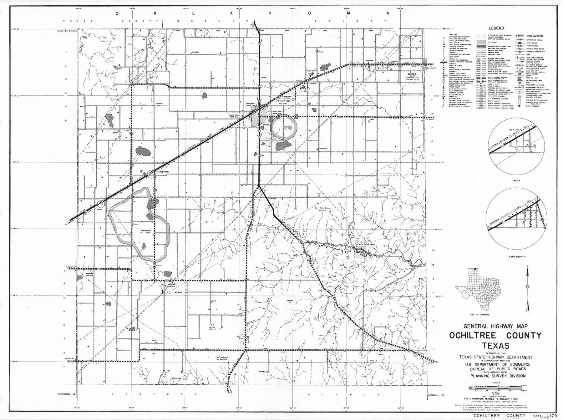
General Highway Map, Ochiltree County, Texas
-
Map/Doc
79618
-
Collection
Texas State Library and Archives
-
Object Dates
1961 (Creation Date)
-
People and Organizations
Texas State Highway Department (Publisher)
-
Counties
Ochiltree
-
Subjects
County
-
Height x Width
18.2 x 24.3 inches
46.2 x 61.7 cm
-
Comments
Prints available courtesy of the Texas State Library and Archives.
More info can be found here: TSLAC Map 05258
Part of: Texas State Library and Archives
Description of Best Route from San Antonio to Laredo, Texas

Print $20.00
Description of Best Route from San Antonio to Laredo, Texas
1865
Size 28.6 x 13.7 inches
Map/Doc 79302
General Highway Map, Delta County, Hopkins County, Texas

Print $20.00
General Highway Map, Delta County, Hopkins County, Texas
1961
Size 24.6 x 18.2 inches
Map/Doc 79439
General Highway Map, Throckmorton County, Texas

Print $20.00
General Highway Map, Throckmorton County, Texas
1940
Size 24.9 x 18.2 inches
Map/Doc 79258
General Highway Map, San Patricio County, Texas

Print $20.00
General Highway Map, San Patricio County, Texas
1961
Size 18.1 x 24.5 inches
Map/Doc 79647
General Highway Map. Detail of Cities and Towns in Harris County, Texas

Print $20.00
General Highway Map. Detail of Cities and Towns in Harris County, Texas
1939
Size 18.4 x 24.9 inches
Map/Doc 79117
General Highway Map, Comanche County, Texas

Print $20.00
General Highway Map, Comanche County, Texas
1940
Size 25.3 x 18.4 inches
Map/Doc 79056

General Highway Map, Falls County, Texas

Print $20.00
General Highway Map, Falls County, Texas
1940
Size 18.5 x 24.7 inches
Map/Doc 79088
Rand McNally Standard Map of Texas

Print $20.00
Rand McNally Standard Map of Texas
1923
Size 27.7 x 40.3 inches
Map/Doc 76259
General Highway Map, San Augustine County, Texas

Print $20.00
General Highway Map, San Augustine County, Texas
1940
Size 24.8 x 18.3 inches
Map/Doc 79235
General Highway Map, Coleman County, Texas

Print $20.00
General Highway Map, Coleman County, Texas
1940
Size 18.4 x 25.2 inches
Map/Doc 79050
General Highway Map, Haskell County, Texas

Print $20.00
General Highway Map, Haskell County, Texas
1940
Size 18.5 x 24.8 inches
Map/Doc 79122
You may also like
Medina County Working Sketch 25

Print $20.00
- Digital $50.00
Medina County Working Sketch 25
1985
Size 37.6 x 42.9 inches
Map/Doc 70940
[Block 35, Townships 3N, 4N, and 5N]
![90640, [Block 35, Townships 3N, 4N, and 5N], Twichell Survey Records](https://historictexasmaps.com/wmedia_w700/maps/90640-1.tif.jpg)
Print $40.00
- Digital $50.00
[Block 35, Townships 3N, 4N, and 5N]
Size 15.6 x 48.1 inches
Map/Doc 90640
Blanco County Sketch File 11

Print $4.00
- Digital $50.00
Blanco County Sketch File 11
Size 4.0 x 7.6 inches
Map/Doc 14590
Loving County, Texas

Print $20.00
- Digital $50.00
Loving County, Texas
1889
Size 18.8 x 23.8 inches
Map/Doc 638
Duval County Boundary File 1e

Print $40.00
- Digital $50.00
Duval County Boundary File 1e
Size 6.1 x 23.1 inches
Map/Doc 52701
Donley County Sketch File B7

Print $20.00
- Digital $50.00
Donley County Sketch File B7
1919
Size 25.5 x 32.4 inches
Map/Doc 11377
Brazos Santiago, Texas

Print $20.00
- Digital $50.00
Brazos Santiago, Texas
1882
Size 9.0 x 16.9 inches
Map/Doc 97186
Flight Mission No. DQN-1K, Frame 68, Calhoun County

Print $20.00
- Digital $50.00
Flight Mission No. DQN-1K, Frame 68, Calhoun County
1953
Size 18.6 x 22.2 inches
Map/Doc 84155
Hall County Sketch File D

Print $8.00
- Digital $50.00
Hall County Sketch File D
1906
Size 14.4 x 8.7 inches
Map/Doc 24792
Duval County Sketch File 35c

Print $6.00
- Digital $50.00
Duval County Sketch File 35c
1935
Size 14.5 x 8.8 inches
Map/Doc 21377
Gregg County Working Sketch 10

Print $20.00
- Digital $50.00
Gregg County Working Sketch 10
1939
Size 34.1 x 26.4 inches
Map/Doc 63276
Origin of Imports and Destination of Exports at Galveston, Tex., during 1921

Print $20.00
- Digital $50.00
Origin of Imports and Destination of Exports at Galveston, Tex., during 1921
1921
Size 13.1 x 24.6 inches
Map/Doc 97169