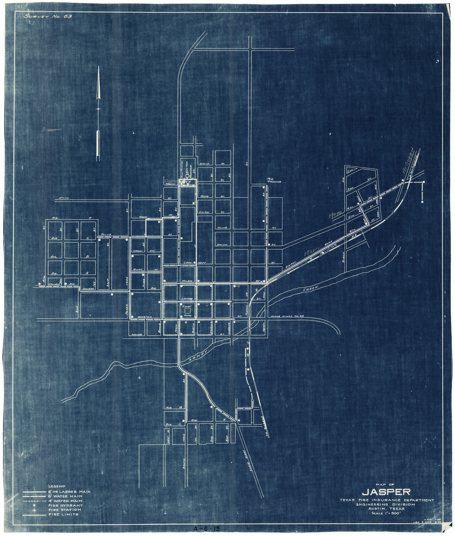
Map of Jasper
A-6-15
-
Map/Doc
2207
-
Collection
General Map Collection
-
Object Dates
1930 (Creation Date)
-
People and Organizations
Texas Fire Insurance Department (Publisher)
-
Counties
Jasper
-
Subjects
City
-
Height x Width
23.7 x 20.1 inches
60.2 x 51.1 cm
-
Medium
blueprint/diazo
-
Scale
1" = 500 feet
-
Comments
Texas Fire Insurance Department, Engineering Division.
Street map showing locations of water mains, fire hydrants and fire station. -
Features
[Road] to San Augustine
State Highway No. 63
Sandy Creek
[Road] to Silsbee
Fairgrounds
Part of: General Map Collection
Scurry County Rolled Sketch 13

Print $20.00
- Digital $50.00
Scurry County Rolled Sketch 13
2002
Size 19.4 x 19.2 inches
Map/Doc 76417
Val Verde County Sketch File L

Print $26.00
- Digital $50.00
Val Verde County Sketch File L
1919
Size 12.4 x 9.1 inches
Map/Doc 39262
Uvalde County Working Sketch 51

Print $20.00
- Digital $50.00
Uvalde County Working Sketch 51
1981
Size 34.7 x 37.7 inches
Map/Doc 72121
Madison County Working Sketch 11

Print $20.00
- Digital $50.00
Madison County Working Sketch 11
1964
Size 39.6 x 33.4 inches
Map/Doc 70773

1910 Map of the City of Houston and vicinity

Print $20.00
- Digital $50.00
1910 Map of the City of Houston and vicinity
1910
Size 20.5 x 23.4 inches
Map/Doc 97452
Topographical Map of the Rio Grande, Sheet No. 2

Print $20.00
- Digital $50.00
Topographical Map of the Rio Grande, Sheet No. 2
1912
Map/Doc 89526
Leon County Working Sketch 27

Print $20.00
- Digital $50.00
Leon County Working Sketch 27
1970
Size 22.4 x 24.4 inches
Map/Doc 70426
Nolan County Sketch File B

Print $20.00
- Digital $50.00
Nolan County Sketch File B
1902
Size 12.0 x 21.5 inches
Map/Doc 42171
Robertson County Sketch File 10 (1)

Print $3.00
- Digital $50.00
Robertson County Sketch File 10 (1)
Size 13.0 x 10.4 inches
Map/Doc 43369
Rio Grande, Penitas Sheet

Print $20.00
- Digital $50.00
Rio Grande, Penitas Sheet
1937
Size 39.8 x 42.0 inches
Map/Doc 69708
Ochiltree County Boundary File 2

Print $4.00
- Digital $50.00
Ochiltree County Boundary File 2
Size 7.7 x 8.6 inches
Map/Doc 57675
You may also like
Harris County Working Sketch 14

Print $20.00
- Digital $50.00
Harris County Working Sketch 14
Size 18.9 x 17.4 inches
Map/Doc 65906
Current Miscellaneous File 79

Print $6.00
- Digital $50.00
Current Miscellaneous File 79
Size 10.8 x 8.4 inches
Map/Doc 74210
Blocks 17, 18 & 19, Capitol Syndicate Subdivision of Capitol Land Reservation Leagues of Portions of Leagues Number 16, 6, 7, 8, 9, 11, 12, 13, 14, 17, 18. 19, 20, 21, 22, 38, 39, 40, 41, 42, 43, 44, 45 and 46

Print $40.00
- Digital $50.00
Blocks 17, 18 & 19, Capitol Syndicate Subdivision of Capitol Land Reservation Leagues of Portions of Leagues Number 16, 6, 7, 8, 9, 11, 12, 13, 14, 17, 18. 19, 20, 21, 22, 38, 39, 40, 41, 42, 43, 44, 45 and 46
Size 50.5 x 30.9 inches
Map/Doc 89686
Cherokee County Sketch File 1

Print $6.00
- Digital $50.00
Cherokee County Sketch File 1
1857
Size 10.6 x 8.0 inches
Map/Doc 18109
Nolan County Rolled Sketch 2

Print $20.00
- Digital $50.00
Nolan County Rolled Sketch 2
1956
Size 27.7 x 35.0 inches
Map/Doc 6860
Brazos River, Brazos River Sheet 1

Print $20.00
- Digital $50.00
Brazos River, Brazos River Sheet 1
1926
Size 20.6 x 24.6 inches
Map/Doc 78264
General Highway Map, Dallas County, Rockwall County, Texas

Print $20.00
General Highway Map, Dallas County, Rockwall County, Texas
1936
Size 18.7 x 25.2 inches
Map/Doc 79066
Dickens County Sketch File 14

Print $20.00
- Digital $50.00
Dickens County Sketch File 14
Size 19.6 x 16.6 inches
Map/Doc 11320
Carte du Chemin de Fer de Galveston, Houston et Henderson

Print $20.00
- Digital $50.00
Carte du Chemin de Fer de Galveston, Houston et Henderson
1857
Size 35.4 x 27.2 inches
Map/Doc 89274
Crockett County Sketch File 98

Print $8.00
- Digital $50.00
Crockett County Sketch File 98
1925
Size 12.5 x 8.9 inches
Map/Doc 19976
Eberstadt and Brock's Subdivisions of the West Half of Survey 187 Block 2 A. B. & M., Randall County Texas

Print $20.00
- Digital $50.00
Eberstadt and Brock's Subdivisions of the West Half of Survey 187 Block 2 A. B. & M., Randall County Texas
Size 17.7 x 29.6 inches
Map/Doc 91748
Haskell County Sketch File 8

Print $20.00
- Digital $50.00
Haskell County Sketch File 8
Size 28.3 x 24.7 inches
Map/Doc 11740