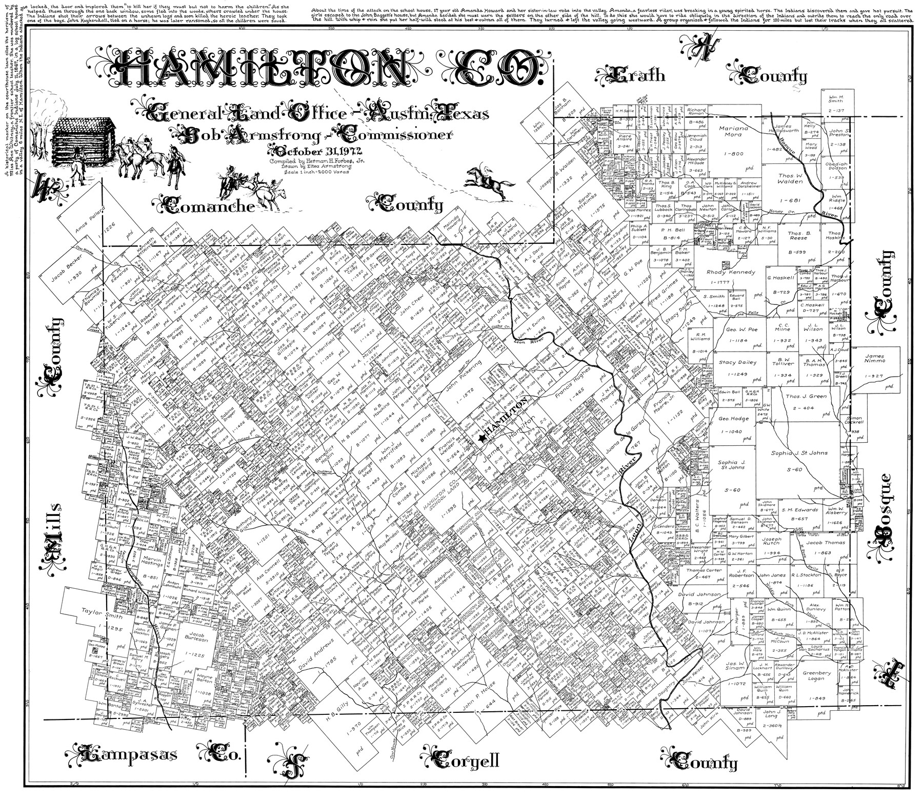
Hamilton Co.
-
Map/Doc
77300
-
Collection
General Map Collection
-
Object Dates
10/31/1972 (Creation Date)
-
People and Organizations
Herman H. Forbes Jr. (Compiler)
Eltea Armstrong (Draftsman)
-
Counties
Hamilton
-
Subjects
County
-
Height x Width
35.8 x 41.5 inches
90.9 x 105.4 cm
Part of: General Map Collection
Map of Baylor County Young Land District, formely Fannin District

Print $20.00
- Digital $50.00
Map of Baylor County Young Land District, formely Fannin District
1859
Size 25.8 x 20.0 inches
Map/Doc 3281
Tarrant County Working Sketch 2

Print $20.00
- Digital $50.00
Tarrant County Working Sketch 2
1940
Size 21.3 x 19.5 inches
Map/Doc 62419
Kaufman County Working Sketch 3

Print $2.00
- Digital $50.00
Kaufman County Working Sketch 3
1922
Size 11.9 x 8.0 inches
Map/Doc 66666
Flight Mission No. DQO-1K, Frame 150, Galveston County

Print $20.00
- Digital $50.00
Flight Mission No. DQO-1K, Frame 150, Galveston County
1952
Size 19.1 x 22.6 inches
Map/Doc 85003
Map of Atascosa Co.

Print $40.00
- Digital $50.00
Map of Atascosa Co.
1894
Size 48.3 x 46.6 inches
Map/Doc 4877
[Map of the Hearne and Brazos Valley Railroad from Mumford to Moseley's Ferry]
![64401, [Map of the Hearne and Brazos Valley Railroad from Mumford to Moseley's Ferry], General Map Collection](https://historictexasmaps.com/wmedia_w700/maps/64401.tif.jpg)
Print $40.00
- Digital $50.00
[Map of the Hearne and Brazos Valley Railroad from Mumford to Moseley's Ferry]
1892
Size 20.0 x 71.5 inches
Map/Doc 64401
Red River County Working Sketch 44

Print $20.00
- Digital $50.00
Red River County Working Sketch 44
1968
Size 28.1 x 28.3 inches
Map/Doc 72027
Newton County Working Sketch 31

Print $20.00
- Digital $50.00
Newton County Working Sketch 31
1955
Size 34.3 x 43.6 inches
Map/Doc 71277
[Right of Way & Track Map, The Texas & Pacific Ry. Co. Main Line]
![64660, [Right of Way & Track Map, The Texas & Pacific Ry. Co. Main Line], General Map Collection](https://historictexasmaps.com/wmedia_w700/maps/64660.tif.jpg)
Print $20.00
- Digital $50.00
[Right of Way & Track Map, The Texas & Pacific Ry. Co. Main Line]
Size 11.0 x 18.6 inches
Map/Doc 64660
Chambers County Aerial Photograph Index Sheet 4

Print $20.00
- Digital $50.00
Chambers County Aerial Photograph Index Sheet 4
1956
Size 19.7 x 15.6 inches
Map/Doc 83685
Sketches of Surveys in Montgomery Co.

Print $2.00
- Digital $50.00
Sketches of Surveys in Montgomery Co.
1845
Size 10.2 x 8.0 inches
Map/Doc 69731
Bexar County Sketch File 21

Print $4.00
- Digital $50.00
Bexar County Sketch File 21
1859
Size 12.2 x 7.9 inches
Map/Doc 14484
You may also like
[Sketch Showing Wm. T. Brewer, John R. Taylor, Wm. F. Butler, Timothy DeVore, L. M. Thorn and adjoining surveys]
![90209, [Sketch Showing Wm. T. Brewer, John R. Taylor, Wm. F. Butler, Timothy DeVore, L. M. Thorn and adjoining surveys], Twichell Survey Records](https://historictexasmaps.com/wmedia_w700/maps/90209-1.tif.jpg)
Print $20.00
- Digital $50.00
[Sketch Showing Wm. T. Brewer, John R. Taylor, Wm. F. Butler, Timothy DeVore, L. M. Thorn and adjoining surveys]
Size 20.2 x 36.6 inches
Map/Doc 90209
Johnson County Working Sketch 23

Print $20.00
- Digital $50.00
Johnson County Working Sketch 23
1997
Size 25.3 x 22.8 inches
Map/Doc 66636
Crockett County Rolled Sketch 24

Print $20.00
- Digital $50.00
Crockett County Rolled Sketch 24
1924
Size 19.5 x 13.0 inches
Map/Doc 5584
Red River County Sketch File 20

Print $4.00
- Digital $50.00
Red River County Sketch File 20
Size 8.2 x 10.1 inches
Map/Doc 35152
Kimble County Rolled Sketch 38

Print $20.00
- Digital $50.00
Kimble County Rolled Sketch 38
1986
Size 28.3 x 21.7 inches
Map/Doc 6528
Hays County Boundary File

Print $120.00
- Digital $50.00
Hays County Boundary File
1947
Size 33.6 x 20.8 inches
Map/Doc 65496
Starr County Working Sketch 28

Print $20.00
- Digital $50.00
Starr County Working Sketch 28
2004
Size 28.0 x 39.6 inches
Map/Doc 83010
Crockett County Sketch File 79a

Print $6.00
- Digital $50.00
Crockett County Sketch File 79a
1937
Size 14.2 x 8.5 inches
Map/Doc 19890
Edwards County Sketch File 6

Print $20.00
- Digital $50.00
Edwards County Sketch File 6
1880
Size 11.7 x 19.6 inches
Map/Doc 11419

Henderson County Working Sketch 39

Print $20.00
- Digital $50.00
Henderson County Working Sketch 39
1982
Size 24.3 x 19.0 inches
Map/Doc 66172
Ellis County Sketch File 2

Print $11.00
- Digital $50.00
Ellis County Sketch File 2
1858
Size 8.4 x 9.7 inches
Map/Doc 21827