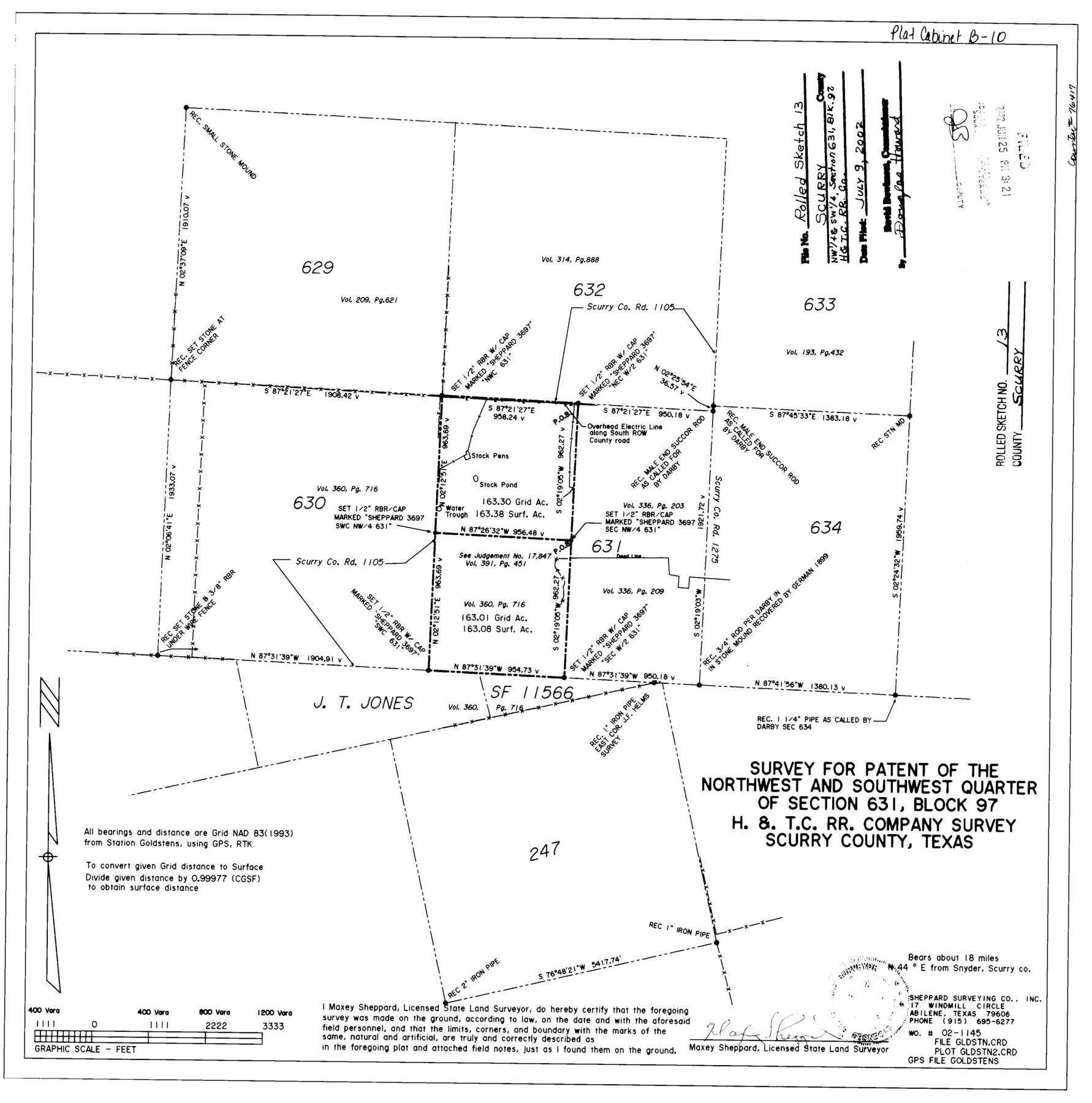
Scurry County Rolled Sketch 13
Survey for patent of the northwest and southwest quarter of section 631, Block 97, H. & T. C. R.R. Company survey, Scurry County, Texas
-
Map/Doc
76417
-
Collection
General Map Collection
-
Object Dates
2002/5/7 (Creation Date)
2002/7/9 (File Date)
-
People and Organizations
Maxey Sheppard (Surveyor/Engineer)
-
Counties
Scurry
-
Subjects
Surveying Rolled Sketch
-
Height x Width
19.4 x 19.2 inches
49.3 x 48.8 cm
-
Medium
mylar, print
Related maps
Scurry County Sketch File 6

Print $14.00
- Digital $50.00
Scurry County Sketch File 6
2002
Size 11.2 x 8.7 inches
Map/Doc 76370
Part of: General Map Collection
Lynn County Rolled Sketch WR

Print $20.00
- Digital $50.00
Lynn County Rolled Sketch WR
Size 14.7 x 23.8 inches
Map/Doc 6656
Flight Mission No. CLL-3N, Frame 15, Willacy County

Print $20.00
- Digital $50.00
Flight Mission No. CLL-3N, Frame 15, Willacy County
1950
Size 18.4 x 22.0 inches
Map/Doc 87081
Angelina County Working Sketch 37

Print $20.00
- Digital $50.00
Angelina County Working Sketch 37
1958
Size 25.7 x 19.1 inches
Map/Doc 67120
Flight Mission No. DQO-8K, Frame 145, Galveston County

Print $20.00
- Digital $50.00
Flight Mission No. DQO-8K, Frame 145, Galveston County
1952
Size 18.6 x 22.5 inches
Map/Doc 85207
Eastland County Working Sketch 52

Print $20.00
- Digital $50.00
Eastland County Working Sketch 52
1982
Size 25.7 x 30.0 inches
Map/Doc 68833
Flight Mission No. DAG-23K, Frame 61, Matagorda County

Print $20.00
- Digital $50.00
Flight Mission No. DAG-23K, Frame 61, Matagorda County
1953
Size 16.0 x 15.7 inches
Map/Doc 86488
Dimmit County

Print $40.00
- Digital $50.00
Dimmit County
1916
Size 40.0 x 48.8 inches
Map/Doc 66806
Wood County Sketch File 7

Print $17.00
- Digital $50.00
Wood County Sketch File 7
1848
Size 11.9 x 7.7 inches
Map/Doc 40645
Menard County Sketch File 13

Print $4.00
- Digital $50.00
Menard County Sketch File 13
1892
Size 12.8 x 8.2 inches
Map/Doc 31506
Nueces County Sketch File 18

Print $4.00
- Digital $50.00
Nueces County Sketch File 18
1874
Size 10.2 x 7.2 inches
Map/Doc 32549

Gaines County Rolled Sketch 20

Print $20.00
- Digital $50.00
Gaines County Rolled Sketch 20
1955
Size 30.1 x 37.2 inches
Map/Doc 5936
You may also like
Franklin County Sketch File 1c

Print $4.00
- Digital $50.00
Franklin County Sketch File 1c
1853
Size 10.3 x 8.1 inches
Map/Doc 23010
El Paso County Sketch File 21

Print $35.00
- Digital $50.00
El Paso County Sketch File 21
1916
Size 14.5 x 9.1 inches
Map/Doc 22014
Bexar County Rolled Sketch 4B

Print $20.00
- Digital $50.00
Bexar County Rolled Sketch 4B
1989
Size 24.3 x 36.7 inches
Map/Doc 5139
Wheeler County Sketch File 1

Print $20.00
- Digital $50.00
Wheeler County Sketch File 1
Size 17.1 x 26.8 inches
Map/Doc 12672
Upton County Rolled Sketch 46

Print $20.00
- Digital $50.00
Upton County Rolled Sketch 46
1955
Size 22.5 x 35.0 inches
Map/Doc 8082
Hutchinson County Working Sketch 47

Print $20.00
- Digital $50.00
Hutchinson County Working Sketch 47
1980
Size 35.2 x 19.9 inches
Map/Doc 66407
Map of Glasscock County

Print $20.00
- Digital $50.00
Map of Glasscock County
Size 18.8 x 25.1 inches
Map/Doc 90783
Map of Location of the Pecos & Northern Texas Railway from Station 7879+36 to Station 8010+08 = 2.48 Miles through Castro County, Texas

Print $20.00
- Digital $50.00
Map of Location of the Pecos & Northern Texas Railway from Station 7879+36 to Station 8010+08 = 2.48 Miles through Castro County, Texas
1898
Size 14.1 x 25.3 inches
Map/Doc 64060
Trace of a copy of the map captured at the battle of Resaca de la Palma

Print $20.00
- Digital $50.00
Trace of a copy of the map captured at the battle of Resaca de la Palma
Size 18.3 x 27.6 inches
Map/Doc 73053
Lamar County Working Sketch 10

Print $20.00
- Digital $50.00
Lamar County Working Sketch 10
1980
Size 18.6 x 15.4 inches
Map/Doc 70271
Dimmit County Working Sketch 49

Print $40.00
- Digital $50.00
Dimmit County Working Sketch 49
1980
Size 78.8 x 44.7 inches
Map/Doc 68710
Map of the Missouri, Kansas & Texas Railway and its connecting lines

Print $20.00
- Digital $50.00
Map of the Missouri, Kansas & Texas Railway and its connecting lines
1901
Size 16.3 x 9.1 inches
Map/Doc 95810