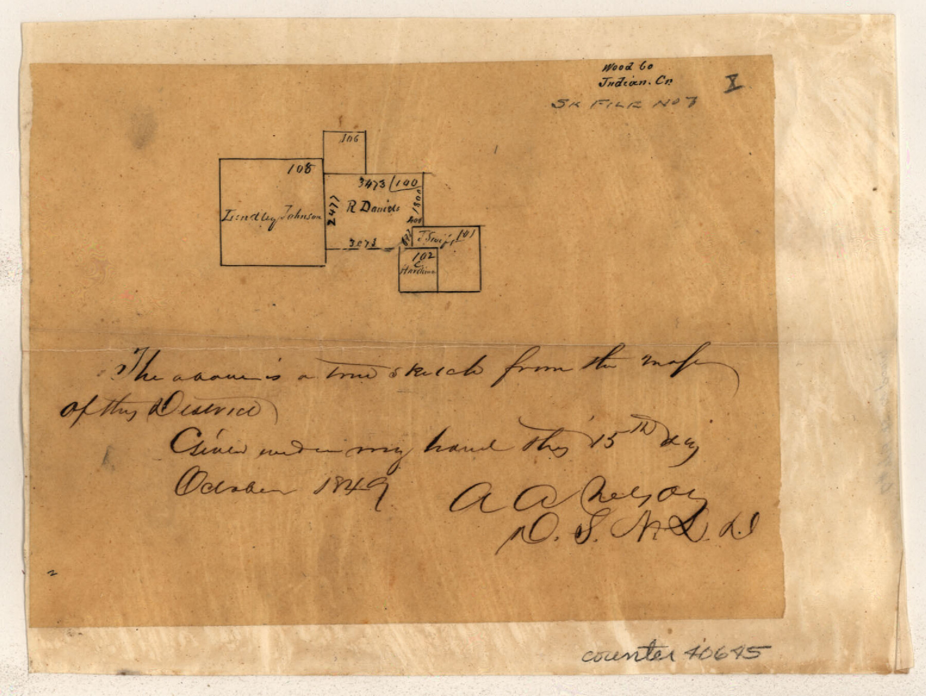
Wood County Sketch File 7
[Multiple sundry sketches within the county]
-
Map/Doc
40645
-
Collection
General Map Collection
-
Object Dates
1848-1851 (Creation Date)
-
People and Organizations
A.A. Nelson (Surveyor/Engineer)
-
Counties
Wood
-
Subjects
Surveying Sketch File
-
Height x Width
11.9 x 7.7 inches
30.2 x 19.6 cm
-
Medium
paper, manuscript
-
Features
Lake Fork [of Sabine River]
Holly Creek
Sandy Creek
Part of: General Map Collection
Flight Mission No. DQO-3K, Frame 23, Galveston County

Print $20.00
- Digital $50.00
Flight Mission No. DQO-3K, Frame 23, Galveston County
1952
Size 18.8 x 22.5 inches
Map/Doc 85064
Archer County Sketch File 23

Print $40.00
- Digital $50.00
Archer County Sketch File 23
1936
Size 25.3 x 23.4 inches
Map/Doc 10831
[Affadavit regarding boundary lines between the several coastal counties from coastline to Continental Shelf]
![2089, [Affadavit regarding boundary lines between the several coastal counties from coastline to Continental Shelf], General Map Collection](https://historictexasmaps.com/wmedia_w700/maps/2089-1.tif.jpg)
Print $20.00
- Digital $50.00
[Affadavit regarding boundary lines between the several coastal counties from coastline to Continental Shelf]
1947
Size 18.1 x 12.7 inches
Map/Doc 2089
Karnes County Working Sketch 3

Print $20.00
- Digital $50.00
Karnes County Working Sketch 3
1943
Size 34.6 x 31.4 inches
Map/Doc 66651
Galveston County Sketch File 5

Print $4.00
- Digital $50.00
Galveston County Sketch File 5
1848
Size 8.6 x 9.0 inches
Map/Doc 23358
San Patricio County Rolled Sketch 42

Print $20.00
- Digital $50.00
San Patricio County Rolled Sketch 42
Size 18.6 x 37.3 inches
Map/Doc 7728
Hopkins County Sketch File 27

Print $6.00
- Digital $50.00
Hopkins County Sketch File 27
1873
Size 16.6 x 11.0 inches
Map/Doc 26738
Leon County Rolled Sketch 6

Print $20.00
- Digital $50.00
Leon County Rolled Sketch 6
1951
Size 31.6 x 37.6 inches
Map/Doc 6597

United States - Gulf Coast - Padre I. and Laguna Madre Lat. 27° 12' to Lat. 26° 33' Texas

Print $20.00
- Digital $50.00
United States - Gulf Coast - Padre I. and Laguna Madre Lat. 27° 12' to Lat. 26° 33' Texas
1913
Size 26.8 x 18.4 inches
Map/Doc 72817
Terrell County Rolled Sketch 37

Print $20.00
- Digital $50.00
Terrell County Rolled Sketch 37
1940
Size 23.8 x 33.3 inches
Map/Doc 7941
Rusk County Working Sketch 7

Print $20.00
- Digital $50.00
Rusk County Working Sketch 7
1982
Size 22.3 x 36.7 inches
Map/Doc 63642
You may also like
Flight Mission No. CLL-1N, Frame 19, Willacy County

Print $20.00
- Digital $50.00
Flight Mission No. CLL-1N, Frame 19, Willacy County
1954
Size 18.3 x 22.1 inches
Map/Doc 87006
The Republic County of Bastrop. January 25, 1840

Print $20.00
The Republic County of Bastrop. January 25, 1840
2020
Size 14.7 x 21.6 inches
Map/Doc 96091
Bee County Sketch File 13

Print $4.00
- Digital $50.00
Bee County Sketch File 13
1876
Size 12.6 x 8.1 inches
Map/Doc 14295
Nueces County Sketch File 26

Print $40.00
- Digital $50.00
Nueces County Sketch File 26
1890
Size 26.7 x 23.2 inches
Map/Doc 42184
Haskell County Sketch File 26

Print $9.00
- Digital $50.00
Haskell County Sketch File 26
1992
Size 11.3 x 8.8 inches
Map/Doc 26182
Pecos County Working Sketch 140

Print $20.00
- Digital $50.00
Pecos County Working Sketch 140
1983
Size 43.1 x 42.9 inches
Map/Doc 71614
Sutton County Working Sketch 58

Print $40.00
- Digital $50.00
Sutton County Working Sketch 58
1958
Size 57.3 x 37.5 inches
Map/Doc 62401
United States - Gulf Coast - Aransas Pass and Corpus Christi Bay with the coast to latitude 27° 12' Texas

Print $20.00
- Digital $50.00
United States - Gulf Coast - Aransas Pass and Corpus Christi Bay with the coast to latitude 27° 12' Texas
1913
Size 27.7 x 18.4 inches
Map/Doc 72795
The Chief Justice County of San Augustine. Lands in Conflict with Sabine County

Print $20.00
The Chief Justice County of San Augustine. Lands in Conflict with Sabine County
2020
Size 14.6 x 21.7 inches
Map/Doc 96071
Polk County Rolled Sketch 30

Print $20.00
- Digital $50.00
Polk County Rolled Sketch 30
1958
Size 27.8 x 31.5 inches
Map/Doc 7316
Oldham County Working Sketch 1

Print $20.00
- Digital $50.00
Oldham County Working Sketch 1
1901
Size 40.2 x 24.7 inches
Map/Doc 71323
Intracoastal Waterway - Galveston Bay to West Bay including Galveston Bay Entrance

Print $20.00
- Digital $50.00
Intracoastal Waterway - Galveston Bay to West Bay including Galveston Bay Entrance
1961
Size 26.9 x 38.9 inches
Map/Doc 69935