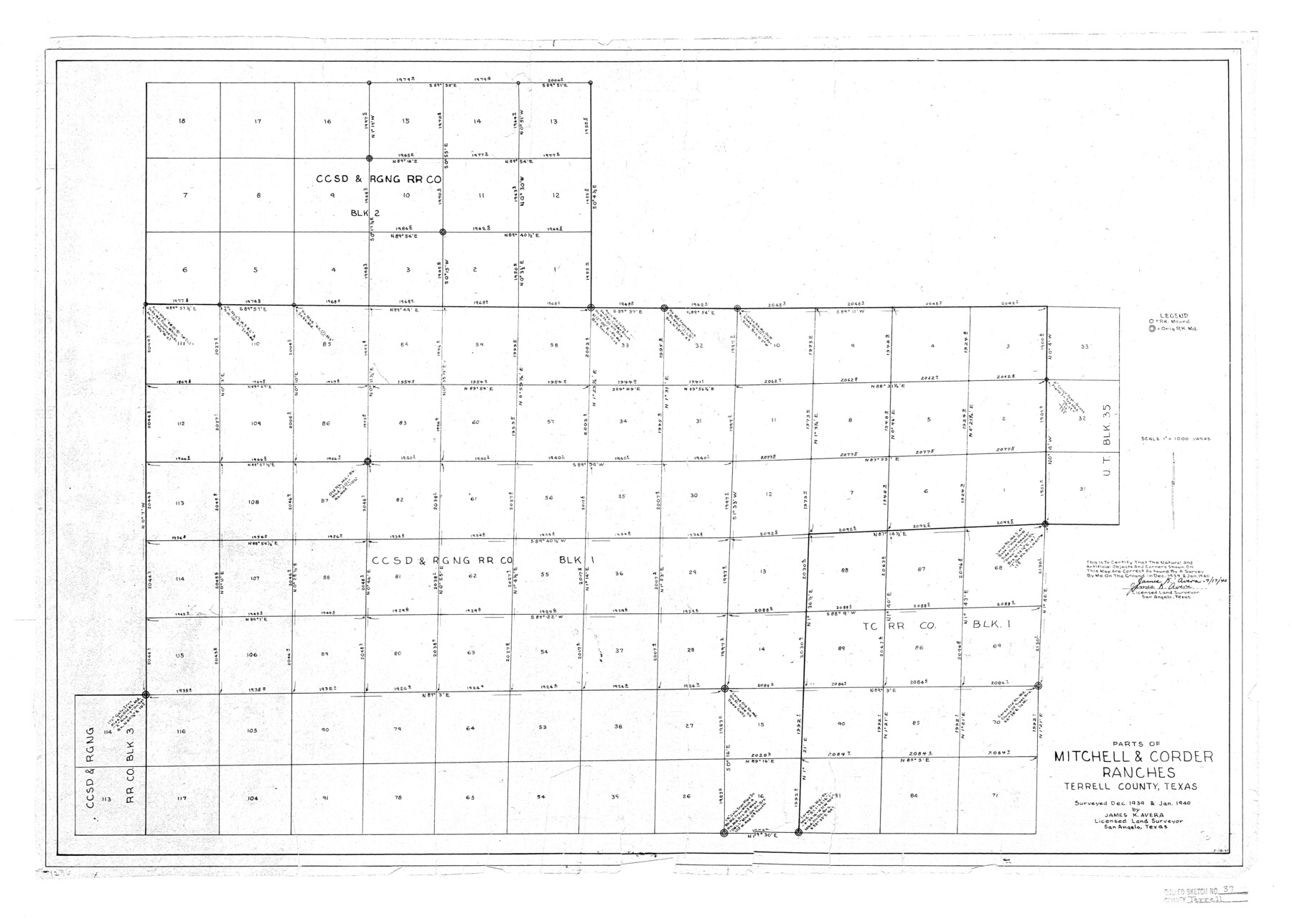
Terrell County Rolled Sketch 37
Parts of Mitchell & Corder Ranches, Terrell County, Texas
-
Map/Doc
7941
-
Collection
General Map Collection
-
Object Dates
1940 (Survey Date)
1940/7/22 (File Date)
1940/7/17 (Creation Date)
-
People and Organizations
James K. Avera (Surveyor/Engineer)
-
Counties
Terrell
-
Subjects
Surveying Rolled Sketch
-
Height x Width
23.8 x 33.3 inches
60.5 x 84.6 cm
-
Scale
1" = 1000 varas
Related maps
Terrell County Sketch File 30

Print $4.00
- Digital $50.00
Terrell County Sketch File 30
1940
Size 11.2 x 8.8 inches
Map/Doc 37979
Part of: General Map Collection
Flight Mission No. CUG-3P, Frame 17, Kleberg County

Print $20.00
- Digital $50.00
Flight Mission No. CUG-3P, Frame 17, Kleberg County
1956
Size 18.6 x 22.3 inches
Map/Doc 86227
Loving County Sketch File 10

Print $2.00
- Digital $50.00
Loving County Sketch File 10
2016
Size 11.0 x 8.5 inches
Map/Doc 94115
Real County Working Sketch 10

Print $20.00
- Digital $50.00
Real County Working Sketch 10
1929
Size 23.0 x 15.4 inches
Map/Doc 71902
Hays County Sketch File C

Print $40.00
- Digital $50.00
Hays County Sketch File C
Size 17.9 x 14.6 inches
Map/Doc 26197
Flight Mission No. BRA-16M, Frame 114, Jefferson County

Print $20.00
- Digital $50.00
Flight Mission No. BRA-16M, Frame 114, Jefferson County
1953
Size 18.5 x 22.3 inches
Map/Doc 85724
Orange County Sketch File 17

Print $50.00
- Digital $50.00
Orange County Sketch File 17
1922
Size 11.1 x 8.6 inches
Map/Doc 33337
Hartley County Sketch File A

Print $4.00
- Digital $50.00
Hartley County Sketch File A
Size 8.9 x 10.4 inches
Map/Doc 26081
El Paso County Rolled Sketch 46

Print $20.00
- Digital $50.00
El Paso County Rolled Sketch 46
1937
Size 38.6 x 30.3 inches
Map/Doc 5832
Wilson County Boundary File 3

Print $26.00
- Digital $50.00
Wilson County Boundary File 3
Size 14.3 x 8.7 inches
Map/Doc 60083
Willacy County Boundary File 1

Print $23.00
- Digital $50.00
Willacy County Boundary File 1
Size 11.3 x 8.8 inches
Map/Doc 59956
Flight Mission No. DQO-8K, Frame 40, Galveston County

Print $20.00
- Digital $50.00
Flight Mission No. DQO-8K, Frame 40, Galveston County
1952
Size 18.5 x 22.3 inches
Map/Doc 85147
Maverick County Sketch File 13a

Print $6.00
- Digital $50.00
Maverick County Sketch File 13a
1883
Size 14.1 x 8.8 inches
Map/Doc 31108
You may also like
Map of Kaufman County showing location of the Texas and Pacific Railway

Print $20.00
- Digital $50.00
Map of Kaufman County showing location of the Texas and Pacific Railway
1872
Size 24.2 x 17.8 inches
Map/Doc 64138
Lynn County Sketch File A1

Print $12.00
- Digital $50.00
Lynn County Sketch File A1
1903
Size 12.7 x 8.2 inches
Map/Doc 30464
Cameron County NRC Article 33.136 Sketch 4

Print $94.00
- Digital $50.00
Cameron County NRC Article 33.136 Sketch 4
2007
Size 22.3 x 34.0 inches
Map/Doc 88721
Clay County Sketch File 29

Print $16.00
- Digital $50.00
Clay County Sketch File 29
Size 11.3 x 8.7 inches
Map/Doc 18448
Angelina County Sketch File 1

Print $40.00
- Digital $50.00
Angelina County Sketch File 1
1848
Size 14.9 x 12.7 inches
Map/Doc 12919

Nueces County Rolled Sketch 39

Print $20.00
- Digital $50.00
Nueces County Rolled Sketch 39
1957
Size 32.9 x 45.3 inches
Map/Doc 6879
Floyd County Working Sketch 2

Print $20.00
- Digital $50.00
Floyd County Working Sketch 2
1911
Size 41.0 x 24.8 inches
Map/Doc 69181
Flight Mission No. DIX-6P, Frame 194, Aransas County

Print $20.00
- Digital $50.00
Flight Mission No. DIX-6P, Frame 194, Aransas County
1956
Size 19.2 x 22.7 inches
Map/Doc 83856
McLennan County Boundary File 4

Print $12.00
- Digital $50.00
McLennan County Boundary File 4
Size 8.8 x 7.5 inches
Map/Doc 56973
[Surveys along Buffalo Bayou]
![153, [Surveys along Buffalo Bayou], General Map Collection](https://historictexasmaps.com/wmedia_w700/maps/153.tif.jpg)
Print $2.00
- Digital $50.00
[Surveys along Buffalo Bayou]
Size 6.3 x 3.9 inches
Map/Doc 153
Gregg County Sketch File 4a

Print $4.00
- Digital $50.00
Gregg County Sketch File 4a
1848
Size 12.7 x 8.1 inches
Map/Doc 24572