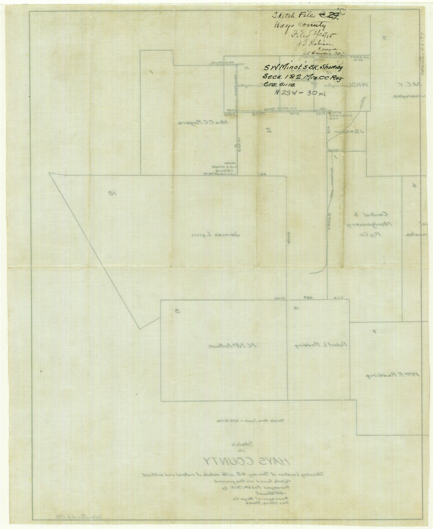
Hays County Sketch File C
[Sketch showing Mrs. C. C. Rogers surveys 1 and 2]
-
Map/Doc
26197
-
Collection
General Map Collection
-
Object Dates
2/25/1915 (File Date)
-
People and Organizations
S.W. Minot (Surveyor/Engineer)
-
Counties
Hays
-
Subjects
Surveying Sketch File
-
Height x Width
17.9 x 14.6 inches
45.5 x 37.1 cm
-
Medium
paper, manuscript
-
Scale
1:500
-
Features
Deadman's Creek
West Prong of Deadman's Creek
Part of: General Map Collection
Donley County Sketch File B8

Print $20.00
- Digital $50.00
Donley County Sketch File B8
1920
Size 15.3 x 15.9 inches
Map/Doc 11378
Bandera County Sketch File 37

Print $24.00
Bandera County Sketch File 37
Size 11.0 x 8.5 inches
Map/Doc 97248
Galveston Island

Print $20.00
- Digital $50.00
Galveston Island
1837
Size 24.1 x 37.2 inches
Map/Doc 2009

Collin County Sketch File 9

Print $4.00
- Digital $50.00
Collin County Sketch File 9
1878
Size 8.3 x 10.1 inches
Map/Doc 18870
Crosby County Working Sketch 15

Print $20.00
- Digital $50.00
Crosby County Working Sketch 15
1977
Size 34.0 x 35.9 inches
Map/Doc 68449
North Part of Brewster Co.

Print $20.00
- Digital $50.00
North Part of Brewster Co.
1956
Size 40.0 x 37.9 inches
Map/Doc 77220
Harris County Sketch File 15

Print $4.00
- Digital $50.00
Harris County Sketch File 15
Size 8.0 x 8.9 inches
Map/Doc 25359

Flight Mission No. DIX-6P, Frame 128, Aransas County

Print $20.00
- Digital $50.00
Flight Mission No. DIX-6P, Frame 128, Aransas County
1956
Size 19.2 x 22.6 inches
Map/Doc 83834
Flight Mission No. DCL-6C, Frame 122, Kenedy County

Print $20.00
- Digital $50.00
Flight Mission No. DCL-6C, Frame 122, Kenedy County
1943
Size 18.5 x 22.4 inches
Map/Doc 85952
Motley County Sketch File 24 (S)

Print $4.00
- Digital $50.00
Motley County Sketch File 24 (S)
Size 9.2 x 7.1 inches
Map/Doc 32204
You may also like
Hartley County Boundary File 4

Print $56.00
- Digital $50.00
Hartley County Boundary File 4
Size 8.6 x 20.7 inches
Map/Doc 54495
Cochran County Working Sketch 4

Print $20.00
- Digital $50.00
Cochran County Working Sketch 4
1984
Size 37.7 x 24.8 inches
Map/Doc 68015
Crockett County Working Sketch 94

Print $20.00
- Digital $50.00
Crockett County Working Sketch 94
1979
Size 43.1 x 28.7 inches
Map/Doc 68427
The Judicial District/County of Ward. Abolished, Spring 1842

Print $20.00
The Judicial District/County of Ward. Abolished, Spring 1842
2020
Size 18.7 x 21.7 inches
Map/Doc 96355
Outer Continental Shelf Leasing Maps (Louisiana Offshore Operations)

Print $20.00
- Digital $50.00
Outer Continental Shelf Leasing Maps (Louisiana Offshore Operations)
1959
Size 17.8 x 14.0 inches
Map/Doc 76106
Map of the Southern Pacific Company and connections

Print $20.00
- Digital $50.00
Map of the Southern Pacific Company and connections
1890
Size 9.6 x 23.8 inches
Map/Doc 95759
Culberson County Working Sketch 89

Print $20.00
- Digital $50.00
Culberson County Working Sketch 89
1984
Size 34.6 x 30.0 inches
Map/Doc 68543
Hutchinson County Sketch File 23

Print $22.00
- Digital $50.00
Hutchinson County Sketch File 23
1913
Size 11.2 x 8.8 inches
Map/Doc 27245
Cottle County Sketch File E

Print $52.00
- Digital $50.00
Cottle County Sketch File E
1901
Size 11.4 x 9.1 inches
Map/Doc 19436
The Yellow Rose Compass

Price $20.00
The Yellow Rose Compass
2025
Size 3.5 x 2.8 inches
Map/Doc 97508
Terrell County Sketch File 9

Print $12.00
- Digital $50.00
Terrell County Sketch File 9
Size 9.8 x 8.5 inches
Map/Doc 37904
Approaches to Galveston Bay

Print $40.00
- Digital $50.00
Approaches to Galveston Bay
1989
Size 37.1 x 55.6 inches
Map/Doc 69887