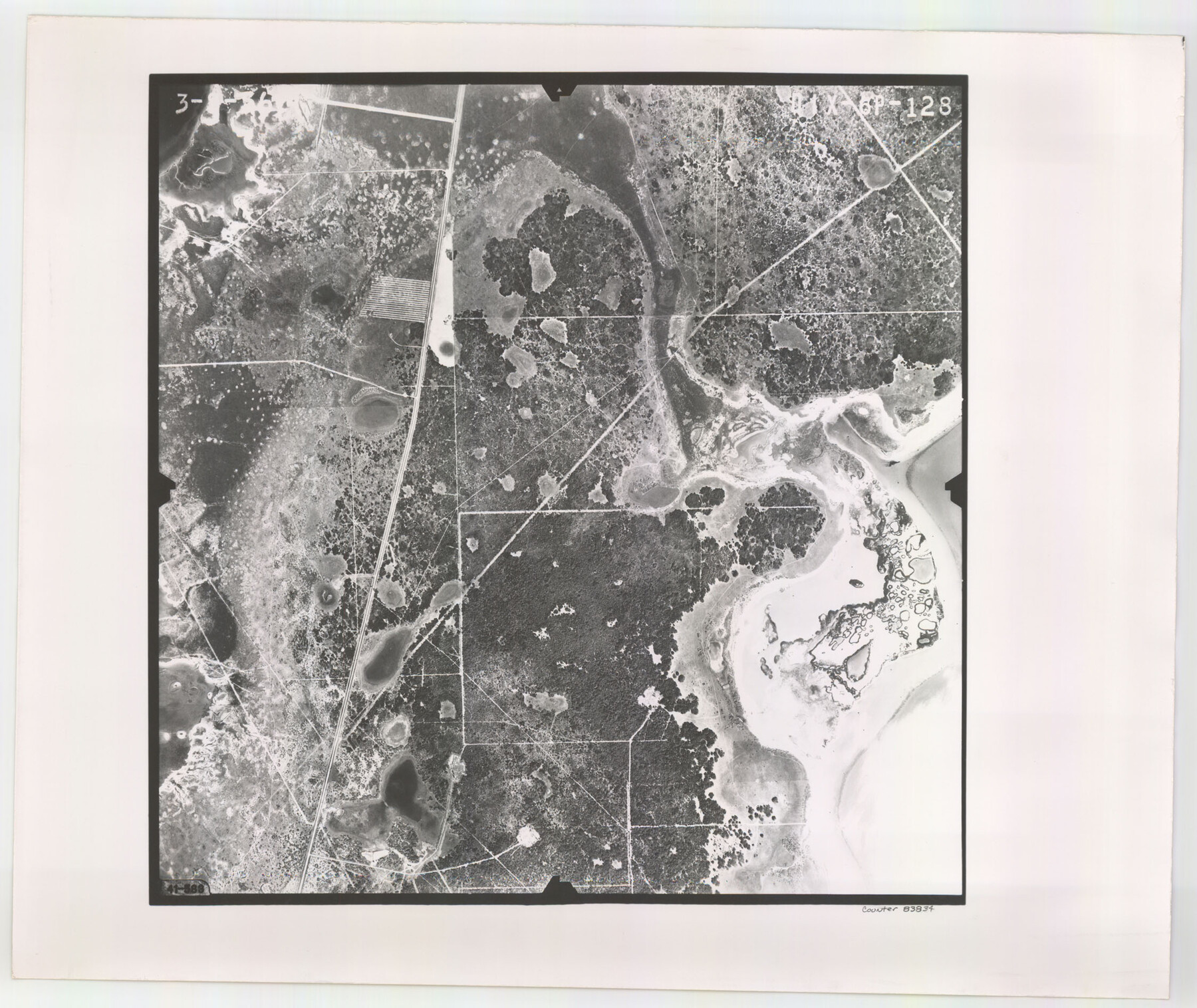
Flight Mission No. DIX-6P, Frame 128, Aransas County
DIX-6P-128
-
Map/Doc
83834
-
Collection
General Map Collection
-
Object Dates
1956/3/8 (Creation Date)
-
People and Organizations
U. S. Department of Agriculture (Publisher)
-
Counties
Aransas
-
Subjects
Aerial Photograph
-
Height x Width
19.2 x 22.6 inches
48.8 x 57.4 cm
-
Comments
Flown by V. L. Beavers and Associates of San Antonio, Texas.
Part of: General Map Collection
Right of Way and Track Map, the Missouri, Kansas and Texas Ry. of Texas - Henrietta Division

Print $20.00
- Digital $50.00
Right of Way and Track Map, the Missouri, Kansas and Texas Ry. of Texas - Henrietta Division
1918
Size 11.8 x 26.8 inches
Map/Doc 64762
Flight Mission No. DQN-5K, Frame 73, Calhoun County

Print $20.00
- Digital $50.00
Flight Mission No. DQN-5K, Frame 73, Calhoun County
1953
Size 18.4 x 22.0 inches
Map/Doc 84406
Jefferson County Working Sketch 31

Print $20.00
- Digital $50.00
Jefferson County Working Sketch 31
1982
Size 21.3 x 27.6 inches
Map/Doc 66575
Starr County Working Sketch 22

Print $20.00
- Digital $50.00
Starr County Working Sketch 22
1983
Size 25.8 x 33.1 inches
Map/Doc 63938
Hutchinson County Rolled Sketch 44-5

Print $20.00
- Digital $50.00
Hutchinson County Rolled Sketch 44-5
2002
Size 24.0 x 36.0 inches
Map/Doc 77541
No. IX - Outline map of the vicinity of Corpus Christi

Print $20.00
- Digital $50.00
No. IX - Outline map of the vicinity of Corpus Christi
Size 24.8 x 18.3 inches
Map/Doc 72967
Travis County Appraisal District Plat Map 2_2915

Print $20.00
- Digital $50.00
Travis County Appraisal District Plat Map 2_2915
Size 21.5 x 26.4 inches
Map/Doc 94219
La Salle County Working Sketch 18

Print $20.00
- Digital $50.00
La Salle County Working Sketch 18
1940
Size 42.5 x 43.3 inches
Map/Doc 70319
Bastrop County

Print $20.00
- Digital $50.00
Bastrop County
1872
Size 21.1 x 17.4 inches
Map/Doc 3279
Lipscomb County Rolled Sketch 5

Print $40.00
- Digital $50.00
Lipscomb County Rolled Sketch 5
Size 9.8 x 62.5 inches
Map/Doc 10639
[Texas Gulf Coast from Rio Grande to Sabine Lake]
![72686, [Texas Gulf Coast from Rio Grande to Sabine Lake], General Map Collection](https://historictexasmaps.com/wmedia_w700/maps/72686.tif.jpg)
Print $20.00
- Digital $50.00
[Texas Gulf Coast from Rio Grande to Sabine Lake]
Size 28.0 x 18.3 inches
Map/Doc 72686
Harrison County Working Sketch 2

Print $20.00
- Digital $50.00
Harrison County Working Sketch 2
1940
Size 40.3 x 36.0 inches
Map/Doc 66022
You may also like
Orange County Sketch File 26

Print $20.00
- Digital $50.00
Orange County Sketch File 26
Size 38.5 x 29.3 inches
Map/Doc 10564
Hutchinson County Rolled Sketch 44-6

Print $20.00
- Digital $50.00
Hutchinson County Rolled Sketch 44-6
2002
Size 24.0 x 36.0 inches
Map/Doc 77542
General Highway Map, Nueces County, Texas

Print $20.00
General Highway Map, Nueces County, Texas
1940
Size 24.6 x 18.5 inches
Map/Doc 79209
Montgomery County Rolled Sketch 14

Print $20.00
- Digital $50.00
Montgomery County Rolled Sketch 14
Size 22.4 x 25.4 inches
Map/Doc 6803
Working Sketch in Bastrop County

Print $20.00
- Digital $50.00
Working Sketch in Bastrop County
1921
Size 14.4 x 22.9 inches
Map/Doc 90205
[Maps of surveys in Reeves & Culberson Cos]
![61132, [Maps of surveys in Reeves & Culberson Cos], General Map Collection](https://historictexasmaps.com/wmedia_w700/maps/61132.tif.jpg)
Print $20.00
- Digital $50.00
[Maps of surveys in Reeves & Culberson Cos]
1937
Size 30.8 x 24.9 inches
Map/Doc 61132
Moore County Sketch File 6

Print $16.00
- Digital $50.00
Moore County Sketch File 6
1902
Size 7.3 x 8.6 inches
Map/Doc 31939
Culberson County Rolled Sketch 19A
Print $20.00
- Digital $50.00
Culberson County Rolled Sketch 19A
Size 23.2 x 28.6 inches
Map/Doc 5652
Right-of-Way and Track Map, Texas State Railroad operated by the T. and N. O. R.R. Co.

Print $40.00
- Digital $50.00
Right-of-Way and Track Map, Texas State Railroad operated by the T. and N. O. R.R. Co.
1917
Size 24.4 x 55.8 inches
Map/Doc 64174
Galveston County NRC Article 33.136 Sketch 70

Print $24.00
- Digital $50.00
Galveston County NRC Article 33.136 Sketch 70
2012
Size 24.0 x 24.3 inches
Map/Doc 95111
Henderson County Rolled Sketch 11

Print $20.00
- Digital $50.00
Henderson County Rolled Sketch 11
1915
Size 29.4 x 42.4 inches
Map/Doc 75957
Waller County Working Sketch Graphic Index

Print $20.00
- Digital $50.00
Waller County Working Sketch Graphic Index
1945
Size 46.7 x 27.2 inches
Map/Doc 76730