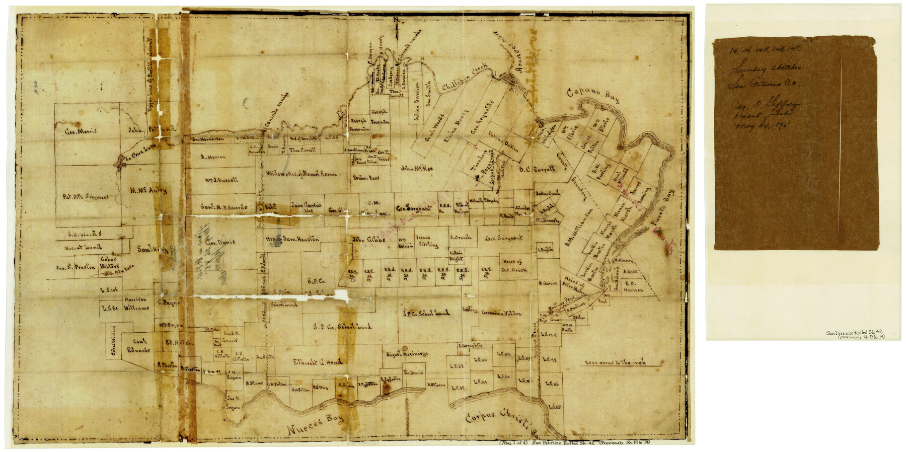
San Patricio County Rolled Sketch 42
[Sketch of east part of San Patricio County and part of Aransas County between Copano Bay and Corpus Christi Bay]
San Patricio County Sketch File 14
-
Map/Doc
7728
-
Collection
General Map Collection
-
Object Dates
5/24/1875 (File Date)
-
People and Organizations
J.O. Gaffney (Surveyor/Engineer)
-
Counties
San Patricio Aransas
-
Subjects
Surveying Rolled Sketch
-
Height x Width
18.6 x 37.3 inches
47.2 x 94.7 cm
-
Medium
paper, manuscript
-
Scale
1" = 2000 varas
Part of: General Map Collection
Texas, San Antonio Bay, Panther Point

Print $40.00
- Digital $50.00
Texas, San Antonio Bay, Panther Point
1934
Size 33.2 x 48.3 inches
Map/Doc 69995
Hudspeth County Sketch File 19

Print $4.00
- Digital $50.00
Hudspeth County Sketch File 19
1901
Size 11.3 x 8.8 inches
Map/Doc 26962
Hardeman County Rolled Sketch 14

Print $40.00
- Digital $50.00
Hardeman County Rolled Sketch 14
1884
Size 23.9 x 59.2 inches
Map/Doc 9099
Nueces County Rolled Sketch 45

Print $20.00
- Digital $50.00
Nueces County Rolled Sketch 45
1941
Size 40.5 x 45.0 inches
Map/Doc 10295
Guadalupe County Working Sketch 11

Print $40.00
- Digital $50.00
Guadalupe County Working Sketch 11
1972
Size 67.7 x 45.0 inches
Map/Doc 63320
Flight Mission No. BRE-1P, Frame 54, Nueces County

Print $20.00
- Digital $50.00
Flight Mission No. BRE-1P, Frame 54, Nueces County
1956
Size 18.4 x 22.2 inches
Map/Doc 86643
Pecos County Rolled Sketch 83

Print $20.00
- Digital $50.00
Pecos County Rolled Sketch 83
1931
Size 17.6 x 26.2 inches
Map/Doc 7242
Ellis County Working Sketch 5

Print $40.00
- Digital $50.00
Ellis County Working Sketch 5
1997
Size 49.2 x 32.4 inches
Map/Doc 69021
Hunt County Working Sketch 11

Print $20.00
- Digital $50.00
Hunt County Working Sketch 11
2002
Size 32.1 x 29.6 inches
Map/Doc 66358
Deaf Smith County Sketch File 1

Print $24.00
- Digital $50.00
Deaf Smith County Sketch File 1
1888
Size 14.4 x 8.8 inches
Map/Doc 20624
Zavala County Working Sketch 21

Print $20.00
- Digital $50.00
Zavala County Working Sketch 21
1979
Size 23.0 x 18.0 inches
Map/Doc 62096
Reeves County Working Sketch 38

Print $20.00
- Digital $50.00
Reeves County Working Sketch 38
1971
Size 36.4 x 39.0 inches
Map/Doc 63481
You may also like
Garza County Rolled Sketch 6E

Print $20.00
- Digital $50.00
Garza County Rolled Sketch 6E
1913
Size 19.2 x 15.6 inches
Map/Doc 5999
San Patricio County Rolled Sketch 49

Print $20.00
- Digital $50.00
San Patricio County Rolled Sketch 49
1979
Size 21.2 x 20.3 inches
Map/Doc 7735
[I. M. Bolton, L. S. Thacker, and R. C. Poteet Subdivisions]
![92579, [I. M. Bolton, L. S. Thacker, and R. C. Poteet Subdivisions], Twichell Survey Records](https://historictexasmaps.com/wmedia_w700/maps/92579-1.tif.jpg)
Print $20.00
- Digital $50.00
[I. M. Bolton, L. S. Thacker, and R. C. Poteet Subdivisions]
1924
Size 18.3 x 24.8 inches
Map/Doc 92579
East Part of Brewster Co.

Print $40.00
- Digital $50.00
East Part of Brewster Co.
1952
Size 48.5 x 30.7 inches
Map/Doc 73087
Andrews County Rolled Sketch 38

Print $40.00
- Digital $50.00
Andrews County Rolled Sketch 38
1963
Size 38.3 x 50.3 inches
Map/Doc 8400
Bandera County Sketch File 30

Print $40.00
- Digital $50.00
Bandera County Sketch File 30
Size 16.8 x 13.4 inches
Map/Doc 14021
Randall County Sketch File 10

Print $4.00
- Digital $50.00
Randall County Sketch File 10
1941
Size 11.4 x 8.8 inches
Map/Doc 34972

Hartley County Sketch File 14

Print $6.00
- Digital $50.00
Hartley County Sketch File 14
1926
Size 11.2 x 8.7 inches
Map/Doc 26110
Texas and Northern Mexico

Print $20.00
- Digital $50.00
Texas and Northern Mexico
1900
Size 21.6 x 28.6 inches
Map/Doc 95895
Henderson County Working Sketch 38

Print $20.00
- Digital $50.00
Henderson County Working Sketch 38
1982
Size 19.3 x 17.0 inches
Map/Doc 66171
DeWitt County

Print $40.00
- Digital $50.00
DeWitt County
1987
Size 42.1 x 50.6 inches
Map/Doc 95481