Garza County Rolled Sketch 6E
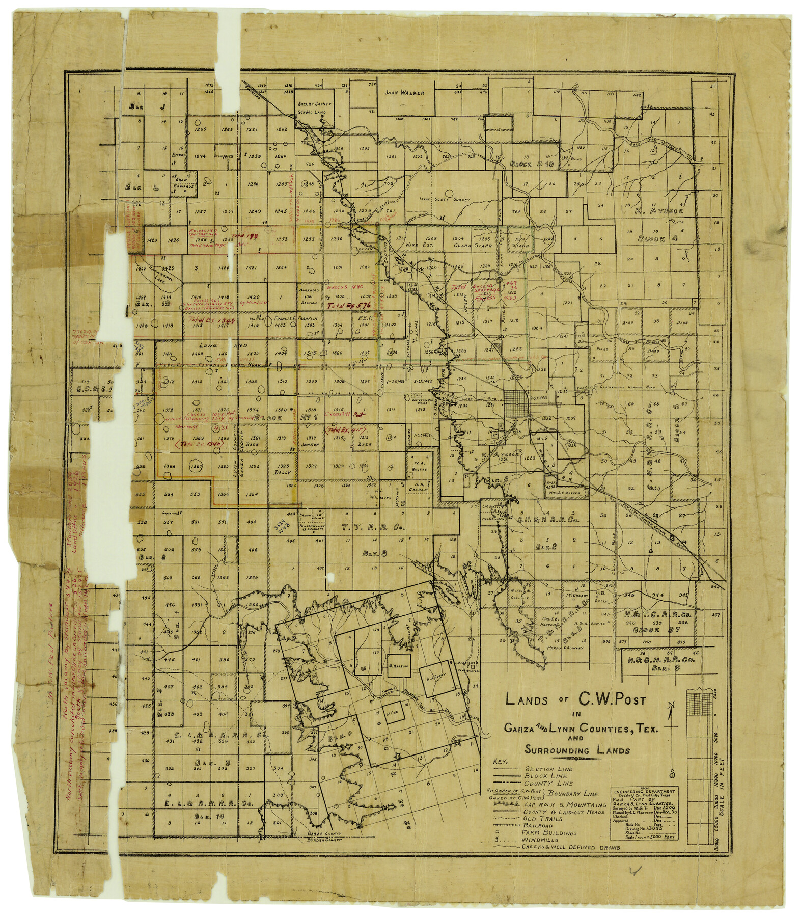
Lands of C.W. Post in Garza and Lynn Counties, Tex. and surrounding lands
-
Map/Doc
5999
-
Collection
General Map Collection
-
Object Dates
12/1913 (Creation Date)
-
Counties
Garza Lynn
-
Subjects
Surveying Rolled Sketch
-
Height x Width
19.2 x 15.6 inches
48.8 x 39.6 cm
-
Medium
paper, etching/engraving/lithograph
-
Scale
1" = 5000 feet
Part of: General Map Collection
Lubbock County Rolled Sketch 6

Print $20.00
- Digital $50.00
Lubbock County Rolled Sketch 6
1914
Size 26.0 x 24.1 inches
Map/Doc 6642
Lipscomb County Boundary File 4

Print $14.00
- Digital $50.00
Lipscomb County Boundary File 4
Size 11.1 x 8.6 inches
Map/Doc 56320
Orange County Working Sketch 27

Print $20.00
- Digital $50.00
Orange County Working Sketch 27
1953
Size 31.0 x 22.9 inches
Map/Doc 71359

Baylor County Boundary File 4

Print $6.00
- Digital $50.00
Baylor County Boundary File 4
Size 11.2 x 8.6 inches
Map/Doc 50389
Burleson County Working Sketch 19

Print $20.00
- Digital $50.00
Burleson County Working Sketch 19
1980
Size 13.5 x 15.1 inches
Map/Doc 67738
Maps of Gulf Intracoastal Waterway, Texas - Sabine River to the Rio Grande and connecting waterways including ship channels

Print $20.00
- Digital $50.00
Maps of Gulf Intracoastal Waterway, Texas - Sabine River to the Rio Grande and connecting waterways including ship channels
1966
Size 14.6 x 22.3 inches
Map/Doc 61962
Orange County Boundary File 9

Print $16.00
- Digital $50.00
Orange County Boundary File 9
Size 11.2 x 8.7 inches
Map/Doc 57782
St. Louis, Brownsville & Mexico Railway Location map from Mile 40 to Mile 60

Print $40.00
- Digital $50.00
St. Louis, Brownsville & Mexico Railway Location map from Mile 40 to Mile 60
1905
Size 19.3 x 61.9 inches
Map/Doc 64080
Rockwall County

Print $20.00
- Digital $50.00
Rockwall County
1941
Size 28.7 x 23.0 inches
Map/Doc 73277
Flight Mission No. BRA-6M, Frame 84, Jefferson County

Print $20.00
- Digital $50.00
Flight Mission No. BRA-6M, Frame 84, Jefferson County
1953
Size 18.6 x 22.4 inches
Map/Doc 85428
Eastland County

Print $20.00
- Digital $50.00
Eastland County
1945
Size 41.8 x 42.0 inches
Map/Doc 77268
You may also like
Brewster County Rolled Sketch 69

Print $20.00
- Digital $50.00
Brewster County Rolled Sketch 69
1940
Size 17.0 x 15.7 inches
Map/Doc 5235
Sutton County

Print $40.00
- Digital $50.00
Sutton County
1941
Size 43.8 x 56.5 inches
Map/Doc 95647
Harris County Sketch File 32a

Print $4.00
- Digital $50.00
Harris County Sketch File 32a
1895
Size 14.1 x 9.0 inches
Map/Doc 25436
Houston County Rolled Sketch 8

Print $20.00
- Digital $50.00
Houston County Rolled Sketch 8
1948
Size 27.7 x 20.3 inches
Map/Doc 6228
Maverick County Working Sketch 22

Print $20.00
- Digital $50.00
Maverick County Working Sketch 22
1978
Size 44.0 x 34.9 inches
Map/Doc 70914
San Patricio County Sketch File 10

Print $8.00
San Patricio County Sketch File 10
1847
Size 13.3 x 8.4 inches
Map/Doc 36040
Hill County Boundary File 45b

Print $60.00
- Digital $50.00
Hill County Boundary File 45b
Size 7.8 x 3.7 inches
Map/Doc 54772
[Maps of surveys in Reeves & Culberson Cos]
![61133, [Maps of surveys in Reeves & Culberson Cos], General Map Collection](https://historictexasmaps.com/wmedia_w700/maps/61133.tif.jpg)
Print $20.00
- Digital $50.00
[Maps of surveys in Reeves & Culberson Cos]
1937
Size 30.7 x 24.8 inches
Map/Doc 61133
Working Sketch in Caldwell County

Print $20.00
- Digital $50.00
Working Sketch in Caldwell County
1922
Size 41.1 x 44.4 inches
Map/Doc 89722
[H. & G. N. RR. Company, Block 1 and Vicinity]
![91232, [H. & G. N. RR. Company, Block 1 and Vicinity], Twichell Survey Records](https://historictexasmaps.com/wmedia_w700/maps/91232-1.tif.jpg)
Print $20.00
- Digital $50.00
[H. & G. N. RR. Company, Block 1 and Vicinity]
Size 14.1 x 17.7 inches
Map/Doc 91232
Zapata County Working Sketch 18

Print $20.00
- Digital $50.00
Zapata County Working Sketch 18
1975
Size 43.2 x 29.1 inches
Map/Doc 62069
Flight Mission No. CGI-1N, Frame 181, Cameron County

Print $20.00
- Digital $50.00
Flight Mission No. CGI-1N, Frame 181, Cameron County
1955
Size 18.7 x 22.2 inches
Map/Doc 84516