Brewster County Rolled Sketch 69
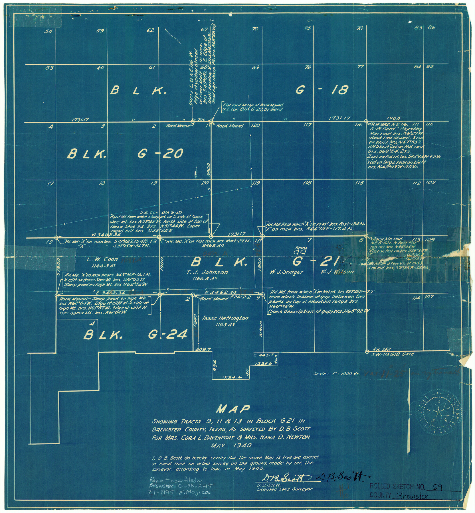
Map showing tracts 9, 11 & 13 in Block G21 in Brewster County, Texas, as surveyed by D.B. Scott for Mrs. Cora L. Davenport & Mrs. Nana D. Newton
-
Map/Doc
5235
-
Collection
General Map Collection
-
Object Dates
5/1940 (Creation Date)
12/21/1940 (File Date)
-
People and Organizations
D.B. Scott (Surveyor/Engineer)
-
Counties
Brewster
-
Subjects
Surveying Rolled Sketch
-
Height x Width
17.0 x 15.7 inches
43.2 x 39.9 cm
-
Medium
blueprint/diazo
-
Scale
1" = 1000 varas
-
Comments
See Brewster County Sketch File 45 (16312) for surveyor’s report.
Related maps
Brewster County Sketch File 45

Print $2.00
- Digital $50.00
Brewster County Sketch File 45
Size 10.7 x 8.2 inches
Map/Doc 16312
Part of: General Map Collection
Flight Mission No. BRA-7M, Frame 199, Jefferson County

Print $20.00
- Digital $50.00
Flight Mission No. BRA-7M, Frame 199, Jefferson County
1953
Size 18.7 x 22.4 inches
Map/Doc 85567
Red River County Working Sketch 62

Print $20.00
- Digital $50.00
Red River County Working Sketch 62
1973
Size 27.1 x 40.0 inches
Map/Doc 72045
Runnels County Working Sketch 25

Print $20.00
- Digital $50.00
Runnels County Working Sketch 25
1955
Size 38.2 x 47.1 inches
Map/Doc 63621
Marshall Ford Dam right of way survey, General Ownership Map

Print $40.00
- Digital $50.00
Marshall Ford Dam right of way survey, General Ownership Map
1942
Size 36.6 x 55.9 inches
Map/Doc 60402
Robertson County Working Sketch 21

Print $20.00
- Digital $50.00
Robertson County Working Sketch 21
2006
Size 44.0 x 33.1 inches
Map/Doc 84701
Gaines County Rolled Sketch 12

Print $20.00
- Digital $50.00
Gaines County Rolled Sketch 12
1940
Size 26.4 x 33.5 inches
Map/Doc 5933
Palo Pinto County

Print $20.00
- Digital $50.00
Palo Pinto County
1896
Size 27.2 x 22.1 inches
Map/Doc 3937
Flight Mission No. DQO-3K, Frame 23, Galveston County

Print $20.00
- Digital $50.00
Flight Mission No. DQO-3K, Frame 23, Galveston County
1952
Size 18.8 x 22.5 inches
Map/Doc 85064
Terry County Rolled Sketch 9

Print $20.00
- Digital $50.00
Terry County Rolled Sketch 9
Size 23.8 x 23.9 inches
Map/Doc 7983
International boundary between the United States and Mexico in the Rio Grande and Colorado River delineated in accordance with the Treaty of November 23, 1970 - Volume 2

International boundary between the United States and Mexico in the Rio Grande and Colorado River delineated in accordance with the Treaty of November 23, 1970 - Volume 2
1974
Size 25.0 x 35.2 inches
Map/Doc 7641
Travis County Rolled Sketch 21

Print $20.00
- Digital $50.00
Travis County Rolled Sketch 21
1941
Size 16.2 x 14.7 inches
Map/Doc 8022
Flight Mission No. CUG-3P, Frame 46, Kleberg County

Print $20.00
- Digital $50.00
Flight Mission No. CUG-3P, Frame 46, Kleberg County
1956
Size 18.5 x 22.2 inches
Map/Doc 86251
You may also like
Culberson County Working Sketch 1

Print $20.00
- Digital $50.00
Culberson County Working Sketch 1
Size 21.6 x 42.7 inches
Map/Doc 68453
La Salle County Rolled Sketch 33

Print $20.00
- Digital $50.00
La Salle County Rolled Sketch 33
2015
Size 17.6 x 27.6 inches
Map/Doc 95306
Gaines County Sketch File 22

Print $20.00
- Digital $50.00
Gaines County Sketch File 22
1962
Size 18.1 x 23.4 inches
Map/Doc 11528
Brewster County Rolled Sketch 17

Print $40.00
- Digital $50.00
Brewster County Rolled Sketch 17
Size 25.1 x 63.4 inches
Map/Doc 5195
Hood County Sketch File 2

Print $4.00
- Digital $50.00
Hood County Sketch File 2
Size 9.7 x 8.2 inches
Map/Doc 26571
Nueces County Working Sketch 12

Print $20.00
- Digital $50.00
Nueces County Working Sketch 12
2011
Size 22.0 x 42.3 inches
Map/Doc 90047
Flight Mission No. DQN-5K, Frame 58, Calhoun County

Print $20.00
- Digital $50.00
Flight Mission No. DQN-5K, Frame 58, Calhoun County
1953
Size 15.5 x 15.3 inches
Map/Doc 84401
[Surveys in Bastrop County]
![3179, [Surveys in Bastrop County], General Map Collection](https://historictexasmaps.com/wmedia_w700/maps/3179.tif.jpg)
Print $2.00
- Digital $50.00
[Surveys in Bastrop County]
1841
Size 11.3 x 8.4 inches
Map/Doc 3179
[Surveys along Rabb's Creek]
![154, [Surveys along Rabb's Creek], General Map Collection](https://historictexasmaps.com/wmedia_w700/maps/154.tif.jpg)
Print $2.00
- Digital $50.00
[Surveys along Rabb's Creek]
1841
Size 8.7 x 11.0 inches
Map/Doc 154
Hudspeth County Working Sketch 20

Print $40.00
- Digital $50.00
Hudspeth County Working Sketch 20
1966
Size 43.8 x 63.6 inches
Map/Doc 66302
Flight Mission No. DCL-7C, Frame 75, Kenedy County

Print $20.00
- Digital $50.00
Flight Mission No. DCL-7C, Frame 75, Kenedy County
1943
Size 15.3 x 15.2 inches
Map/Doc 86061
Map of Cooke County originally Fannin Land District

Print $20.00
- Digital $50.00
Map of Cooke County originally Fannin Land District
1858
Size 25.4 x 18.9 inches
Map/Doc 950