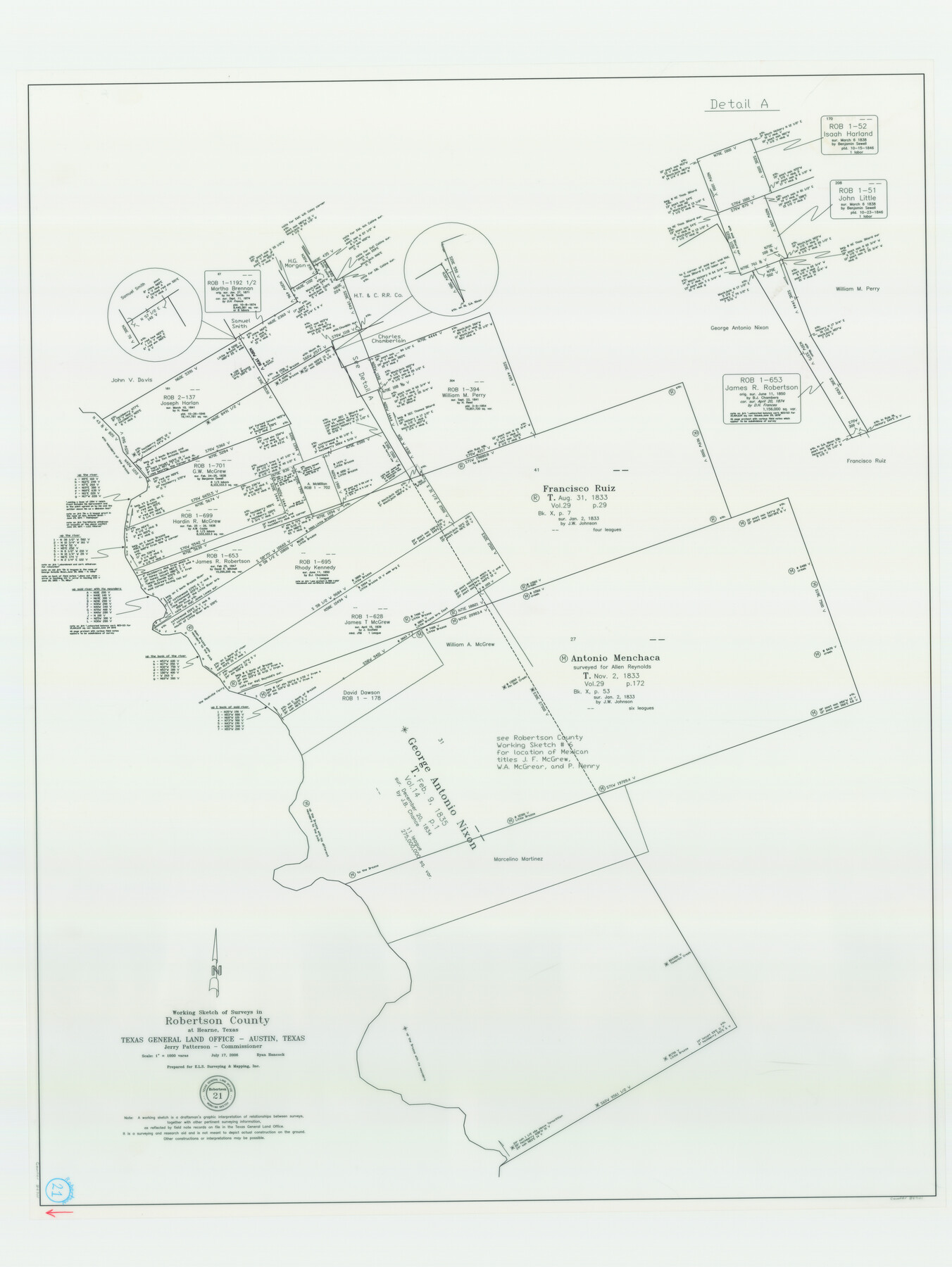
Robertson County Working Sketch 21
-
Map/Doc
84701
-
Collection
General Map Collection
-
Object Dates
7/17/2006 (Creation Date)
-
People and Organizations
Ryan Hancock (Draftsman)
-
Counties
Robertson
-
Subjects
Surveying Working Sketch
-
Height x Width
44.0 x 33.1 inches
111.8 x 84.1 cm
-
Scale
1" = 1000 varas
-
Comments
Flown by Jack Ammann Photogrammetric Engineers, Inc. of San Antonio, Texas.
Part of: General Map Collection
Uvalde County Rolled Sketch 24

Print $20.00
- Digital $50.00
Uvalde County Rolled Sketch 24
2014
Size 16.2 x 16.1 inches
Map/Doc 93722
Lee County Working Sketch 3

Print $20.00
- Digital $50.00
Lee County Working Sketch 3
1968
Size 37.9 x 37.3 inches
Map/Doc 70382
Crockett County Sketch File 47

Print $6.00
- Digital $50.00
Crockett County Sketch File 47
1882
Size 14.3 x 8.8 inches
Map/Doc 19789
Kerr County Working Sketch 22

Print $40.00
- Digital $50.00
Kerr County Working Sketch 22
1965
Size 50.9 x 40.4 inches
Map/Doc 70053
Travis County Boundary File 20

Print $6.00
- Digital $50.00
Travis County Boundary File 20
Size 14.4 x 9.2 inches
Map/Doc 59454
Hudspeth County Sketch File 25

Print $10.00
- Digital $50.00
Hudspeth County Sketch File 25
1936
Size 11.3 x 8.7 inches
Map/Doc 26979
[Surveys in Austin's Colony south of the San Antonio Road and west of the Colorado River]
![50, [Surveys in Austin's Colony south of the San Antonio Road and west of the Colorado River], General Map Collection](https://historictexasmaps.com/wmedia_w700/maps/50.tif.jpg)
Print $20.00
- Digital $50.00
[Surveys in Austin's Colony south of the San Antonio Road and west of the Colorado River]
1840
Size 16.8 x 22.2 inches
Map/Doc 50
Kenedy County Rolled Sketch 13

Print $20.00
- Digital $50.00
Kenedy County Rolled Sketch 13
1946
Size 38.2 x 45.5 inches
Map/Doc 9334
Galveston County Rolled Sketch S

Print $20.00
- Digital $50.00
Galveston County Rolled Sketch S
1935
Size 36.0 x 46.8 inches
Map/Doc 9088
Flight Mission No. DAH-9M, Frame 85, Orange County

Print $20.00
- Digital $50.00
Flight Mission No. DAH-9M, Frame 85, Orange County
1953
Size 18.5 x 22.7 inches
Map/Doc 86849
Flight Mission No. CLL-3N, Frame 12, Willacy County

Print $20.00
- Digital $50.00
Flight Mission No. CLL-3N, Frame 12, Willacy County
1954
Size 18.4 x 22.0 inches
Map/Doc 87078
Kerr County Boundary File 6

Print $8.00
- Digital $50.00
Kerr County Boundary File 6
Size 14.2 x 8.7 inches
Map/Doc 64822
You may also like
Lynn County Sketch File A3

Print $4.00
- Digital $50.00
Lynn County Sketch File A3
1904
Size 12.7 x 8.0 inches
Map/Doc 30473
Crockett County Rolled Sketch E

Print $20.00
- Digital $50.00
Crockett County Rolled Sketch E
1907
Size 26.2 x 27.7 inches
Map/Doc 5636
Taylor County Sketch File 22

Print $189.00
- Digital $50.00
Taylor County Sketch File 22
1985
Size 14.6 x 8.9 inches
Map/Doc 37826
Kimble County Working Sketch 59

Print $20.00
- Digital $50.00
Kimble County Working Sketch 59
1963
Size 24.6 x 40.8 inches
Map/Doc 70127
The Republic County of Matagorda. Refined, January 25, 1841

Print $20.00
The Republic County of Matagorda. Refined, January 25, 1841
2020
Size 19.3 x 21.8 inches
Map/Doc 96221
Presidio County Rolled Sketch A-2

Print $20.00
- Digital $50.00
Presidio County Rolled Sketch A-2
1889
Size 36.9 x 43.9 inches
Map/Doc 9770
Edwards County Working Sketch 100

Print $20.00
- Digital $50.00
Edwards County Working Sketch 100
1971
Size 31.5 x 34.2 inches
Map/Doc 68976
Lynn County Boundary File 4

Print $4.00
- Digital $50.00
Lynn County Boundary File 4
Size 11.3 x 8.7 inches
Map/Doc 56626
Lubbock County Rolled Sketch 3

Print $20.00
- Digital $50.00
Lubbock County Rolled Sketch 3
Size 25.0 x 38.7 inches
Map/Doc 9469
Harrison County Working Sketch 1

Print $20.00
- Digital $50.00
Harrison County Working Sketch 1
1919
Size 22.6 x 25.6 inches
Map/Doc 66021
Township 6 North Range 13 West, North Western District, Louisiana

Print $20.00
- Digital $50.00
Township 6 North Range 13 West, North Western District, Louisiana
1841
Size 19.7 x 24.8 inches
Map/Doc 65864
Map of Baylor County

Print $20.00
- Digital $50.00
Map of Baylor County
1895
Size 47.4 x 37.0 inches
Map/Doc 4882