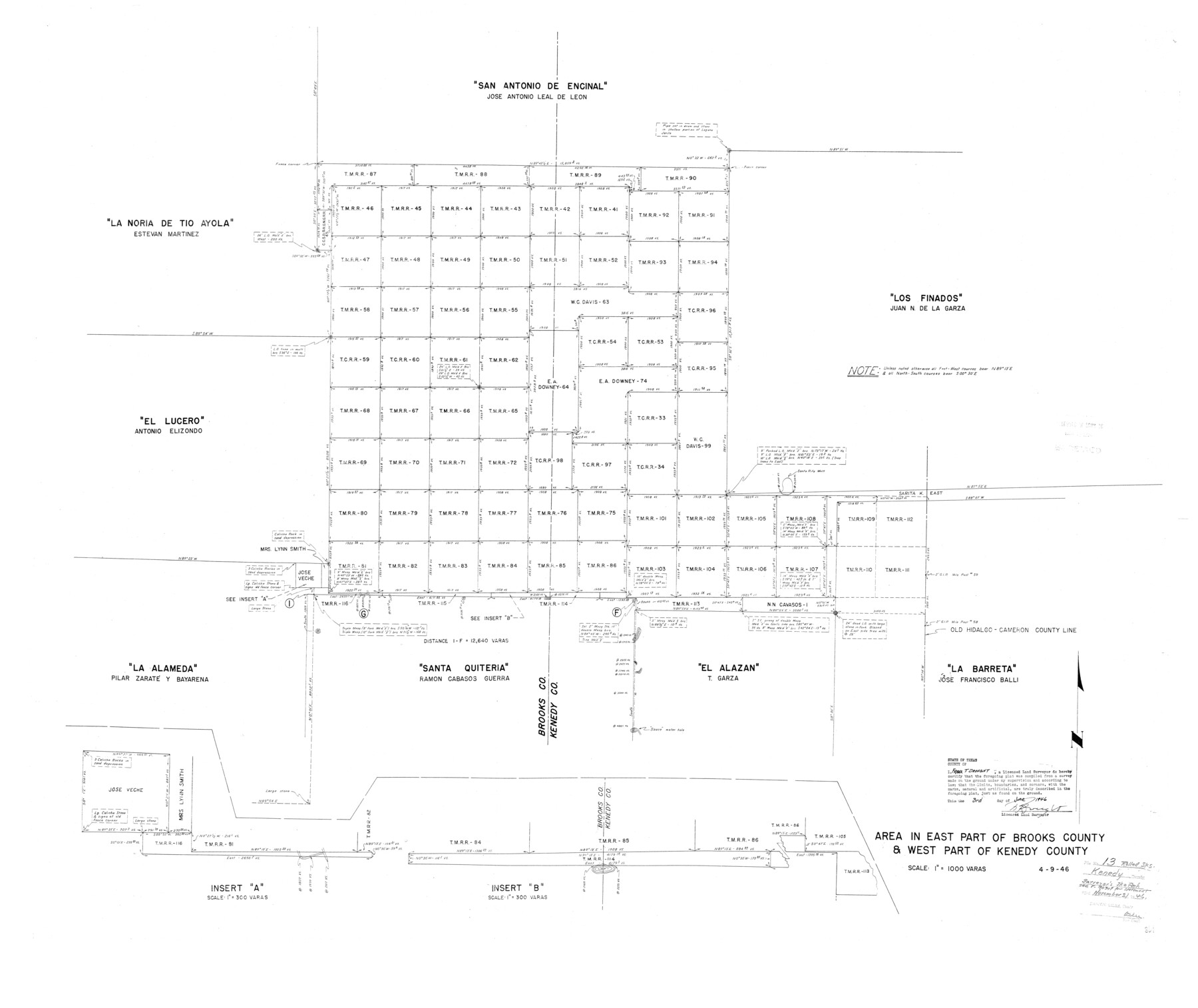
Kenedy County Rolled Sketch 13
Area in east part of Brooks County & west part of Kenedy County
-
Map/Doc
9334
-
Collection
General Map Collection
-
Object Dates
6/3/1946 (Creation Date)
11/21/1946 (File Date)
-
People and Organizations
Frank T. Drought (Surveyor/Engineer)
-
Counties
Kenedy Brooks
-
Subjects
Surveying Rolled Sketch
-
Height x Width
38.2 x 45.5 inches
97.0 x 115.6 cm
-
Scale
1" = 1000 varas
-
Comments
See Brooks County Rolled Sketch 29 (5347) for sketch and School File 90349 for surveyor's statement.
Related maps
Brooks County Rolled Sketch 29

Print $20.00
- Digital $50.00
Brooks County Rolled Sketch 29
1947
Size 31.3 x 22.9 inches
Map/Doc 5347
Part of: General Map Collection

Flight Mission No. BRA-7M, Frame 11, Jefferson County

Print $20.00
- Digital $50.00
Flight Mission No. BRA-7M, Frame 11, Jefferson County
1953
Size 18.6 x 22.3 inches
Map/Doc 85462
Travis County Working Sketch 50

Print $20.00
- Digital $50.00
Travis County Working Sketch 50
1984
Size 37.8 x 29.0 inches
Map/Doc 69434
Flight Mission No. CRC-3R, Frame 198, Chambers County

Print $20.00
- Digital $50.00
Flight Mission No. CRC-3R, Frame 198, Chambers County
1956
Size 18.5 x 22.2 inches
Map/Doc 84853
Grayson County Boundary File 4

Print $16.00
- Digital $50.00
Grayson County Boundary File 4
Size 12.7 x 8.0 inches
Map/Doc 53948
Map of Cass Co.

Print $20.00
- Digital $50.00
Map of Cass Co.
1862
Size 17.8 x 19.6 inches
Map/Doc 3372
Gulf Coast of the United States, Key West to Rio Grande

Print $20.00
- Digital $50.00
Gulf Coast of the United States, Key West to Rio Grande
1892
Size 27.5 x 18.3 inches
Map/Doc 72669
Potter County Sketch File 15

Print $20.00
- Digital $50.00
Potter County Sketch File 15
Size 19.5 x 21.1 inches
Map/Doc 12201
Flight Mission No. DQN-1K, Frame 33, Calhoun County

Print $20.00
- Digital $50.00
Flight Mission No. DQN-1K, Frame 33, Calhoun County
1953
Size 15.5 x 15.5 inches
Map/Doc 84138
[Surveys in the Jasper District]
![69734, [Surveys in the Jasper District], General Map Collection](https://historictexasmaps.com/wmedia_w700/maps/69734.tif.jpg)
Print $2.00
- Digital $50.00
[Surveys in the Jasper District]
1847
Size 9.4 x 6.9 inches
Map/Doc 69734
Bee County Sketch File X

Print $6.00
- Digital $50.00
Bee County Sketch File X
Size 11.5 x 11.0 inches
Map/Doc 14243
Flight Mission No. CLL-1N, Frame 21, Willacy County

Print $20.00
- Digital $50.00
Flight Mission No. CLL-1N, Frame 21, Willacy County
1954
Size 18.7 x 22.3 inches
Map/Doc 87008
You may also like
Upton County Working Sketch 35

Print $20.00
- Digital $50.00
Upton County Working Sketch 35
1956
Size 42.8 x 30.5 inches
Map/Doc 69531
Brewster County Sketch File NS-4e

Print $26.00
- Digital $50.00
Brewster County Sketch File NS-4e
1930
Size 8.7 x 11.2 inches
Map/Doc 15965
Crockett County Sketch File 90

Print $40.00
- Digital $50.00
Crockett County Sketch File 90
1961
Size 14.7 x 23.5 inches
Map/Doc 11238
Jackson County

Print $40.00
- Digital $50.00
Jackson County
1920
Size 49.5 x 41.8 inches
Map/Doc 66878
Hamilton County Working Sketch 8

Print $20.00
- Digital $50.00
Hamilton County Working Sketch 8
1943
Size 27.6 x 28.5 inches
Map/Doc 63346
Brewster County Sketch File S-1

Print $10.00
- Digital $50.00
Brewster County Sketch File S-1
1921
Size 13.3 x 8.8 inches
Map/Doc 15726
Culberson County Sketch File 1b

Print $20.00
- Digital $50.00
Culberson County Sketch File 1b
Size 9.0 x 18.0 inches
Map/Doc 11260
Upton County Sketch File 6

Print $10.00
- Digital $50.00
Upton County Sketch File 6
1909
Size 11.3 x 8.6 inches
Map/Doc 38815
Live Oak County Rolled Sketch 6

Print $20.00
- Digital $50.00
Live Oak County Rolled Sketch 6
1947
Size 43.6 x 25.9 inches
Map/Doc 6634
Jeff Davis County Working Sketch 5

Print $20.00
- Digital $50.00
Jeff Davis County Working Sketch 5
1920
Size 12.9 x 22.2 inches
Map/Doc 66500
[T. & P. RR. Co. Blocks 31-36, Townships 3N, 4N and 5N and surrounding area]
![93135, [T. & P. RR. Co. Blocks 31-36, Townships 3N, 4N and 5N and surrounding area], Twichell Survey Records](https://historictexasmaps.com/wmedia_w700/maps/93135-1.tif.jpg)
Print $40.00
- Digital $50.00
[T. & P. RR. Co. Blocks 31-36, Townships 3N, 4N and 5N and surrounding area]
Size 51.3 x 51.5 inches
Map/Doc 93135
Hardeman County Aerial Photograph Index Sheet 1

Print $20.00
- Digital $50.00
Hardeman County Aerial Photograph Index Sheet 1
1950
Size 19.8 x 17.0 inches
Map/Doc 83697