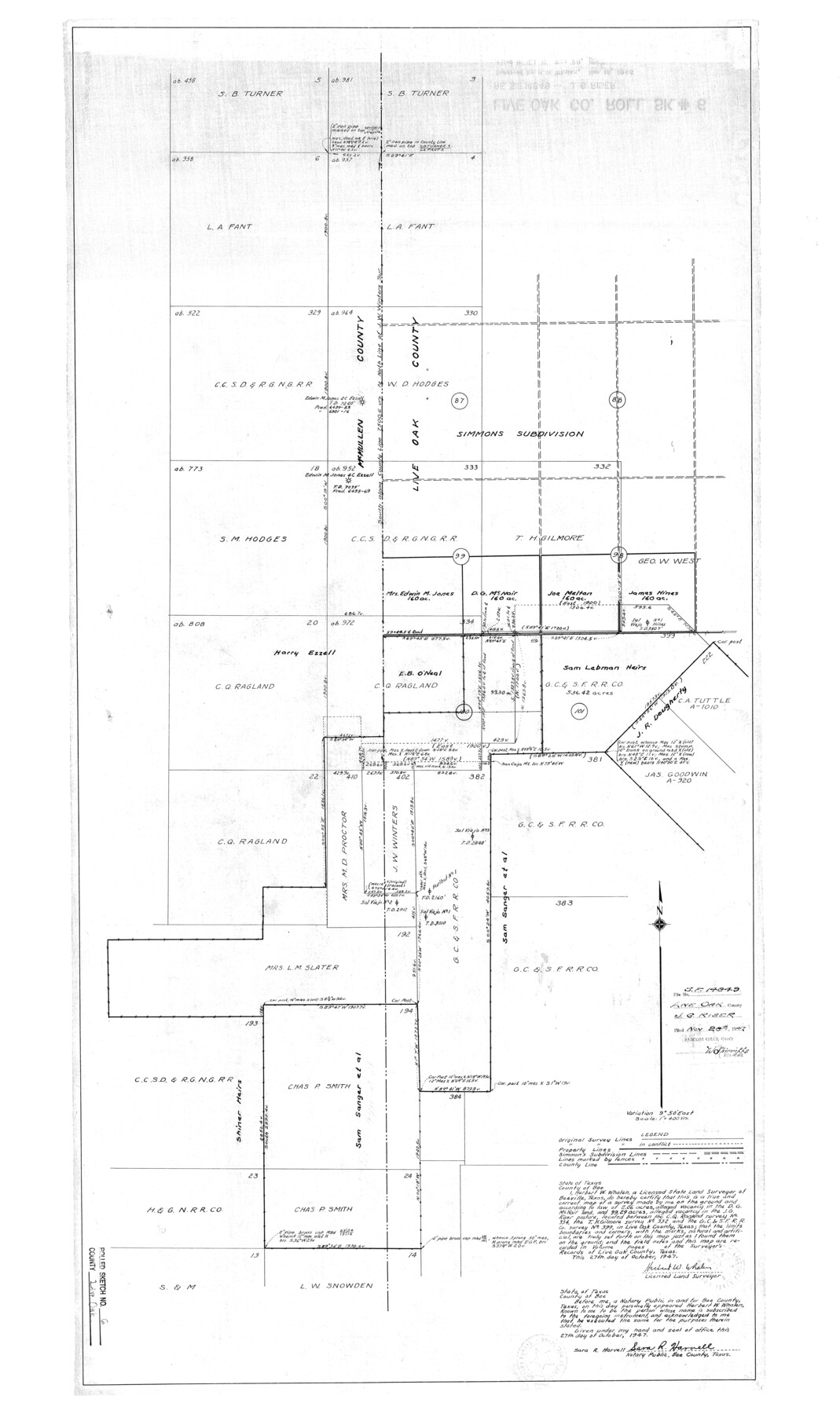
Live Oak County Rolled Sketch 6
[Plat of area along McMullen-Live Oak County line]
-
Map/Doc
6634
-
Collection
General Map Collection
-
Object Dates
1947/10/27 (Creation Date)
1947/11/28 (File Date)
-
People and Organizations
Herbert W. Whalen (Surveyor/Engineer)
-
Counties
Live Oak McMullen
-
Subjects
Surveying Rolled Sketch
-
Height x Width
43.6 x 25.9 inches
110.7 x 65.8 cm
-
Scale
1" = 400 varas
Part of: General Map Collection
Flight Mission No. CRC-2R, Frame 110, Chambers County

Print $20.00
- Digital $50.00
Flight Mission No. CRC-2R, Frame 110, Chambers County
1956
Size 18.6 x 22.3 inches
Map/Doc 84737
Mills County Boundary File 1a

Print $60.00
- Digital $50.00
Mills County Boundary File 1a
Size 9.7 x 31.6 inches
Map/Doc 57273
Texas Gulf Coast Map from the Sabine River to the Rio Grande as subdivided for mineral development

Print $20.00
- Digital $50.00
Texas Gulf Coast Map from the Sabine River to the Rio Grande as subdivided for mineral development
1948
Size 41.6 x 39.2 inches
Map/Doc 2904
Flight Mission No. CRK-5P, Frame 158, Refugio County

Print $20.00
- Digital $50.00
Flight Mission No. CRK-5P, Frame 158, Refugio County
1956
Size 18.6 x 22.5 inches
Map/Doc 86939
Upton County Rolled Sketch 59

Print $40.00
- Digital $50.00
Upton County Rolled Sketch 59
1994
Size 36.3 x 49.0 inches
Map/Doc 10638
Outer Continental Shelf Leasing Maps (Texas Offshore Operations)

Print $20.00
- Digital $50.00
Outer Continental Shelf Leasing Maps (Texas Offshore Operations)
Size 24.0 x 18.4 inches
Map/Doc 75853
Brazoria County Sketch File 10

Print $40.00
- Digital $50.00
Brazoria County Sketch File 10
Size 16.4 x 12.7 inches
Map/Doc 14938
Greer County Sketch File 3

Print $20.00
- Digital $50.00
Greer County Sketch File 3
Size 20.1 x 18.2 inches
Map/Doc 11583
Flight Mission No. BRA-17M, Frame 8, Jefferson County

Print $20.00
- Digital $50.00
Flight Mission No. BRA-17M, Frame 8, Jefferson County
1953
Size 18.6 x 22.3 inches
Map/Doc 85789
Kimble County Working Sketch 51

Print $20.00
- Digital $50.00
Kimble County Working Sketch 51
1953
Size 36.3 x 40.1 inches
Map/Doc 70119
Winkler County Working Sketch 14

Print $20.00
- Digital $50.00
Winkler County Working Sketch 14
1961
Size 42.9 x 41.4 inches
Map/Doc 72608
Duval County Boundary File 1e

Print $40.00
- Digital $50.00
Duval County Boundary File 1e
Size 6.1 x 23.1 inches
Map/Doc 52701
You may also like
Surveys in the Milam District at the fork of the Yegua and Brazos Rivers and on the Leon River

Print $2.00
- Digital $50.00
Surveys in the Milam District at the fork of the Yegua and Brazos Rivers and on the Leon River
1846
Size 9.2 x 16.0 inches
Map/Doc 254
Portion of Lynn and Terry Counties

Print $20.00
- Digital $50.00
Portion of Lynn and Terry Counties
Size 34.2 x 35.5 inches
Map/Doc 92934
Houston County Working Sketch 17

Print $40.00
- Digital $50.00
Houston County Working Sketch 17
1968
Size 43.4 x 50.3 inches
Map/Doc 66247
Map of Chocolate Bay, west portion of West Bay & vicinity, Brazoria & Galveston Counties showing subdivision for mineral development

Print $40.00
- Digital $50.00
Map of Chocolate Bay, west portion of West Bay & vicinity, Brazoria & Galveston Counties showing subdivision for mineral development
Size 42.0 x 58.1 inches
Map/Doc 65806
Kimble County Working Sketch 69

Print $20.00
- Digital $50.00
Kimble County Working Sketch 69
1965
Size 42.4 x 30.5 inches
Map/Doc 70137
Harris County Historic Topographic 18

Print $20.00
- Digital $50.00
Harris County Historic Topographic 18
1916
Size 29.4 x 23.0 inches
Map/Doc 65828
Gregg County Rolled Sketch 25

Print $40.00
- Digital $50.00
Gregg County Rolled Sketch 25
1933
Size 27.3 x 51.7 inches
Map/Doc 9076
El Paso County Rolled Sketch Z51

Print $40.00
- Digital $50.00
El Paso County Rolled Sketch Z51
1915
Size 37.2 x 49.0 inches
Map/Doc 8868
Duval County Sketch File 67

Print $16.00
- Digital $50.00
Duval County Sketch File 67
1949
Size 14.2 x 8.8 inches
Map/Doc 21448
Castro County Sketch File 4i

Print $4.00
- Digital $50.00
Castro County Sketch File 4i
Size 13.6 x 8.9 inches
Map/Doc 17481
Glasscock County

Print $20.00
- Digital $50.00
Glasscock County
1887
Size 20.5 x 19.5 inches
Map/Doc 3584
DeWitt County Sketch File 14

Print $8.00
- Digital $50.00
DeWitt County Sketch File 14
1873
Size 12.8 x 8.2 inches
Map/Doc 20827