Duval County Sketch File 67
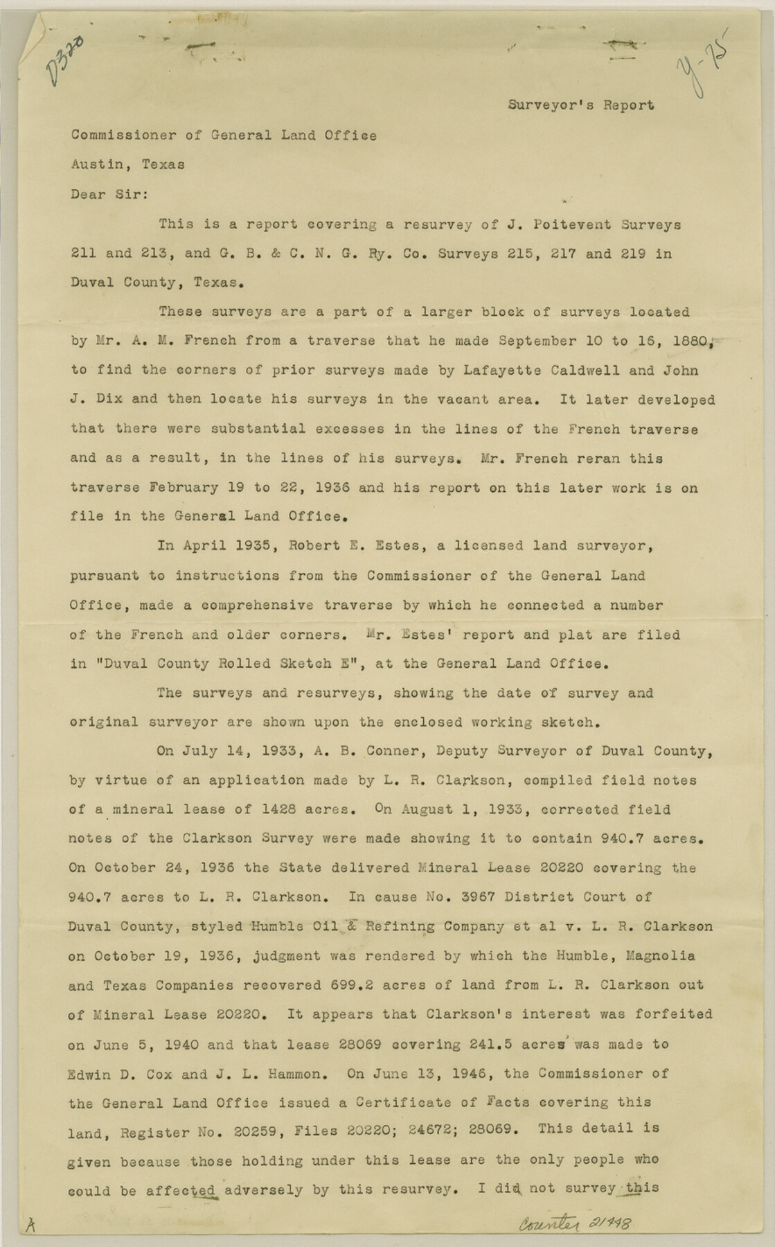
[Report covering a resurvey of J. Poitevent surveys 211 and 213 and G. B. & C. N. G. RR. Co. surveys 215, 217 and 219]
-
Map/Doc
21448
-
Collection
General Map Collection
-
Object Dates
1949/3/30 (Creation Date)
1949/6/1 (File Date)
-
People and Organizations
Phillip G. Young (Surveyor/Engineer)
A.M. French (Surveyor/Engineer)
Lafayette Caldwell (Surveyor/Engineer)
John J. Dix (Surveyor/Engineer)
Robert E. Estes (Surveyor/Engineer)
A.B. Connor (Surveyor/Engineer)
Hayes Dix (Surveyor/Engineer)
J.C. Caldwell (Surveyor/Engineer)
-
Counties
Duval
-
Subjects
Surveying Sketch File
-
Height x Width
14.2 x 8.8 inches
36.1 x 22.4 cm
-
Medium
paper, print
-
Comments
See Duval County Rolled Sketch 32 (8817) for sketch.
Related maps
Duval County Rolled Sketch 32

Print $20.00
- Digital $50.00
Duval County Rolled Sketch 32
Size 38.5 x 37.3 inches
Map/Doc 8817
Part of: General Map Collection
Live Oak County Working Sketch 28

Print $20.00
- Digital $50.00
Live Oak County Working Sketch 28
1982
Size 33.3 x 21.1 inches
Map/Doc 70613
Gulf Intracoastal Waterway - Aransas Bay to Corpus Christi Bay, Modified Route of Main Channel Location of Spoil Disposal Areas

Print $20.00
- Digital $50.00
Gulf Intracoastal Waterway - Aransas Bay to Corpus Christi Bay, Modified Route of Main Channel Location of Spoil Disposal Areas
1961
Size 31.4 x 42.1 inches
Map/Doc 61829
Liberty County Sketch File B

Print $4.00
- Digital $50.00
Liberty County Sketch File B
1869
Size 12.0 x 8.2 inches
Map/Doc 30066
Hardeman County Working Sketch 6

Print $20.00
- Digital $50.00
Hardeman County Working Sketch 6
1944
Size 25.9 x 17.8 inches
Map/Doc 63387
Houston County Working Sketch 23

Print $20.00
- Digital $50.00
Houston County Working Sketch 23
1983
Size 19.4 x 25.3 inches
Map/Doc 66253
Harris County Sketch File 58

Print $20.00
- Digital $50.00
Harris County Sketch File 58
1920
Size 27.6 x 21.4 inches
Map/Doc 11657
Hays County Working Sketch 3

Print $20.00
- Digital $50.00
Hays County Working Sketch 3
1925
Size 28.2 x 24.1 inches
Map/Doc 66077
Milam County Sketch File 5

Print $4.00
- Digital $50.00
Milam County Sketch File 5
1901
Size 14.2 x 8.7 inches
Map/Doc 31632
Rusk County Working Sketch 37a

Print $40.00
- Digital $50.00
Rusk County Working Sketch 37a
2007
Size 54.5 x 34.2 inches
Map/Doc 87496
Jefferson County Working Sketch 21

Print $40.00
- Digital $50.00
Jefferson County Working Sketch 21
1969
Size 31.3 x 60.5 inches
Map/Doc 66564
Kleberg County Rolled Sketch 10-3

Print $20.00
- Digital $50.00
Kleberg County Rolled Sketch 10-3
1951
Size 37.5 x 32.0 inches
Map/Doc 9388
Hood County Working Sketch 18

Print $40.00
- Digital $50.00
Hood County Working Sketch 18
1987
Size 38.8 x 59.0 inches
Map/Doc 66212
You may also like
Williamson County Sketch File 16

Print $20.00
- Digital $50.00
Williamson County Sketch File 16
Size 16.8 x 25.5 inches
Map/Doc 12693
Robertson County Sketch File 5

Print $6.00
Robertson County Sketch File 5
1863
Size 12.0 x 9.0 inches
Map/Doc 35358
Map of Kerr County Texas

Print $20.00
- Digital $50.00
Map of Kerr County Texas
1879
Size 20.3 x 28.3 inches
Map/Doc 3763
[Blocks 24, B9, 3KA]
![90326, [Blocks 24, B9, 3KA], Twichell Survey Records](https://historictexasmaps.com/wmedia_w700/maps/90326-1.tif.jpg)
Print $20.00
- Digital $50.00
[Blocks 24, B9, 3KA]
Size 18.2 x 14.0 inches
Map/Doc 90326
![91466, [Block B7], Twichell Survey Records](https://historictexasmaps.com/wmedia_w700/maps/91466-1.tif.jpg)
Gregg County Working Sketch 24

Print $20.00
- Digital $50.00
Gregg County Working Sketch 24
1985
Size 26.6 x 16.3 inches
Map/Doc 63291
Reeves County Working Sketch 26

Print $20.00
- Digital $50.00
Reeves County Working Sketch 26
1967
Size 44.5 x 36.0 inches
Map/Doc 63469
Midland County

Print $20.00
- Digital $50.00
Midland County
1930
Size 45.7 x 39.6 inches
Map/Doc 66930
[Blocks 47, Z, XO2, M18, M23, M25, and H]
![91236, [Blocks 47, Z, XO2, M18, M23, M25, and H], Twichell Survey Records](https://historictexasmaps.com/wmedia_w700/maps/91236-1.tif.jpg)
Print $20.00
- Digital $50.00
[Blocks 47, Z, XO2, M18, M23, M25, and H]
Size 29.6 x 23.6 inches
Map/Doc 91236
Brewster County Rolled Sketch 60

Print $40.00
- Digital $50.00
Brewster County Rolled Sketch 60
Size 36.6 x 50.3 inches
Map/Doc 10692
Hemphill County Working Sketch 12

Print $20.00
- Digital $50.00
Hemphill County Working Sketch 12
1967
Size 23.3 x 34.9 inches
Map/Doc 66107
Schleicher County Working Sketch 11

Print $20.00
- Digital $50.00
Schleicher County Working Sketch 11
1924
Size 18.9 x 13.8 inches
Map/Doc 63813