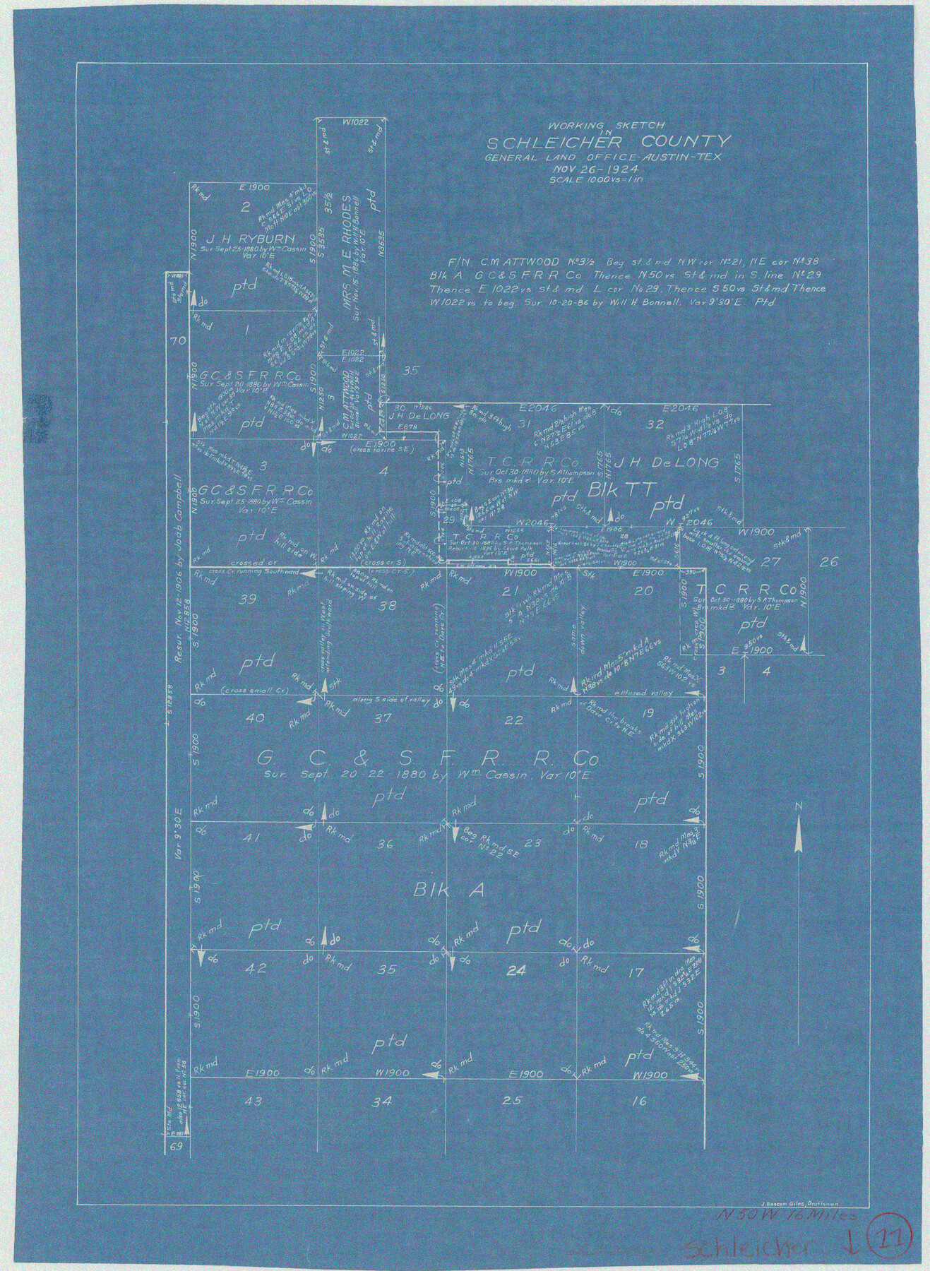
Schleicher County Working Sketch 11
-
Map/Doc
63813
-
Collection
General Map Collection
-
Object Dates
11/26/1924 (Creation Date)
-
People and Organizations
J. Bascom Giles (Draftsman)
-
Counties
Schleicher
-
Subjects
Surveying Working Sketch
-
Height x Width
18.9 x 13.8 inches
48.0 x 35.1 cm
-
Scale
1" = 1000 varas
Part of: General Map Collection

Crockett County Rolled Sketch 84

Print $20.00
- Digital $50.00
Crockett County Rolled Sketch 84
1961
Size 31.9 x 25.2 inches
Map/Doc 5624
Liberty County Working Sketch 22

Print $20.00
- Digital $50.00
Liberty County Working Sketch 22
1941
Size 19.6 x 26.1 inches
Map/Doc 70481
Tom Green County Sketch File 14

Print $20.00
- Digital $50.00
Tom Green County Sketch File 14
Size 34.8 x 45.7 inches
Map/Doc 10401
Gaines County Rolled Sketch 24

Print $20.00
- Digital $50.00
Gaines County Rolled Sketch 24
1965
Size 41.8 x 31.3 inches
Map/Doc 9314
Kimble County Sketch File 19

Print $6.00
- Digital $50.00
Kimble County Sketch File 19
Size 9.9 x 15.0 inches
Map/Doc 28955
Young County Working Sketch 11

Print $40.00
- Digital $50.00
Young County Working Sketch 11
1921
Size 17.2 x 126.4 inches
Map/Doc 62034
[Surveys between the Sabine River and Little Cypress Creek]
![139, [Surveys between the Sabine River and Little Cypress Creek], General Map Collection](https://historictexasmaps.com/wmedia_w700/maps/139.tif.jpg)
Print $3.00
- Digital $50.00
[Surveys between the Sabine River and Little Cypress Creek]
1840
Size 9.3 x 13.0 inches
Map/Doc 139
Kendall County Rolled Sketch 8

Print $20.00
- Digital $50.00
Kendall County Rolled Sketch 8
1994
Size 17.0 x 18.3 inches
Map/Doc 6461
Hockley County Rolled Sketch 5

Print $40.00
- Digital $50.00
Hockley County Rolled Sketch 5
Size 80.8 x 29.5 inches
Map/Doc 9175
Atascosa County Rolled Sketch 9

Print $20.00
- Digital $50.00
Atascosa County Rolled Sketch 9
1905
Size 34.5 x 26.9 inches
Map/Doc 5093
Potter County Sketch File 6

Print $20.00
- Digital $50.00
Potter County Sketch File 6
1900
Size 34.4 x 29.0 inches
Map/Doc 10575
You may also like
Kingston South Quadrangle

Print $20.00
- Digital $50.00
Kingston South Quadrangle
1999
Size 35.4 x 23.4 inches
Map/Doc 97364
Polk County Boundary File 2a

Print $40.00
- Digital $50.00
Polk County Boundary File 2a
Size 31.6 x 9.6 inches
Map/Doc 57928
![89869, [Morton], Twichell Survey Records](https://historictexasmaps.com/wmedia_w700/maps/89869-1.tif.jpg)
Flight Mission No. DQN-1K, Frame 137, Calhoun County

Print $20.00
- Digital $50.00
Flight Mission No. DQN-1K, Frame 137, Calhoun County
1953
Size 18.5 x 22.2 inches
Map/Doc 84200
Boundary Between the United States & Mexico Agreed upon by the Joint Commission under the Treaty of Guadalupe Hidalgo

Print $4.00
- Digital $50.00
Boundary Between the United States & Mexico Agreed upon by the Joint Commission under the Treaty of Guadalupe Hidalgo
1853
Size 18.3 x 26.9 inches
Map/Doc 72880
Map of Eagle Lake

Print $20.00
- Digital $50.00
Map of Eagle Lake
1938
Size 13.0 x 17.0 inches
Map/Doc 2208
Presidio County Working Sketch 73

Print $20.00
- Digital $50.00
Presidio County Working Sketch 73
1962
Size 17.7 x 29.4 inches
Map/Doc 71750
Andrews County Working Sketch 19

Print $20.00
- Digital $50.00
Andrews County Working Sketch 19
1964
Size 24.9 x 23.5 inches
Map/Doc 67065
Jefferson County Working Sketch 26

Print $20.00
- Digital $50.00
Jefferson County Working Sketch 26
1977
Size 39.9 x 36.8 inches
Map/Doc 66569
Anderson County Boundary File 1

Print $10.00
- Digital $50.00
Anderson County Boundary File 1
Size 14.2 x 8.6 inches
Map/Doc 49726
[Plat showing connecting lines for the purpose of locating 4.3 acres in Caldwell County]
![90220, [Plat showing connecting lines for the purpose of locating 4.3 acres in Caldwell County], Twichell Survey Records](https://historictexasmaps.com/wmedia_w700/maps/90220-1.tif.jpg)
Print $2.00
- Digital $50.00
[Plat showing connecting lines for the purpose of locating 4.3 acres in Caldwell County]
1923
Size 7.4 x 10.2 inches
Map/Doc 90220
San Antonio of the 17th, 18th, and 19th Centuries: A Chronology of Her Romantic Past

San Antonio of the 17th, 18th, and 19th Centuries: A Chronology of Her Romantic Past
1929
Size 8.1 x 5.1 inches
Map/Doc 97044