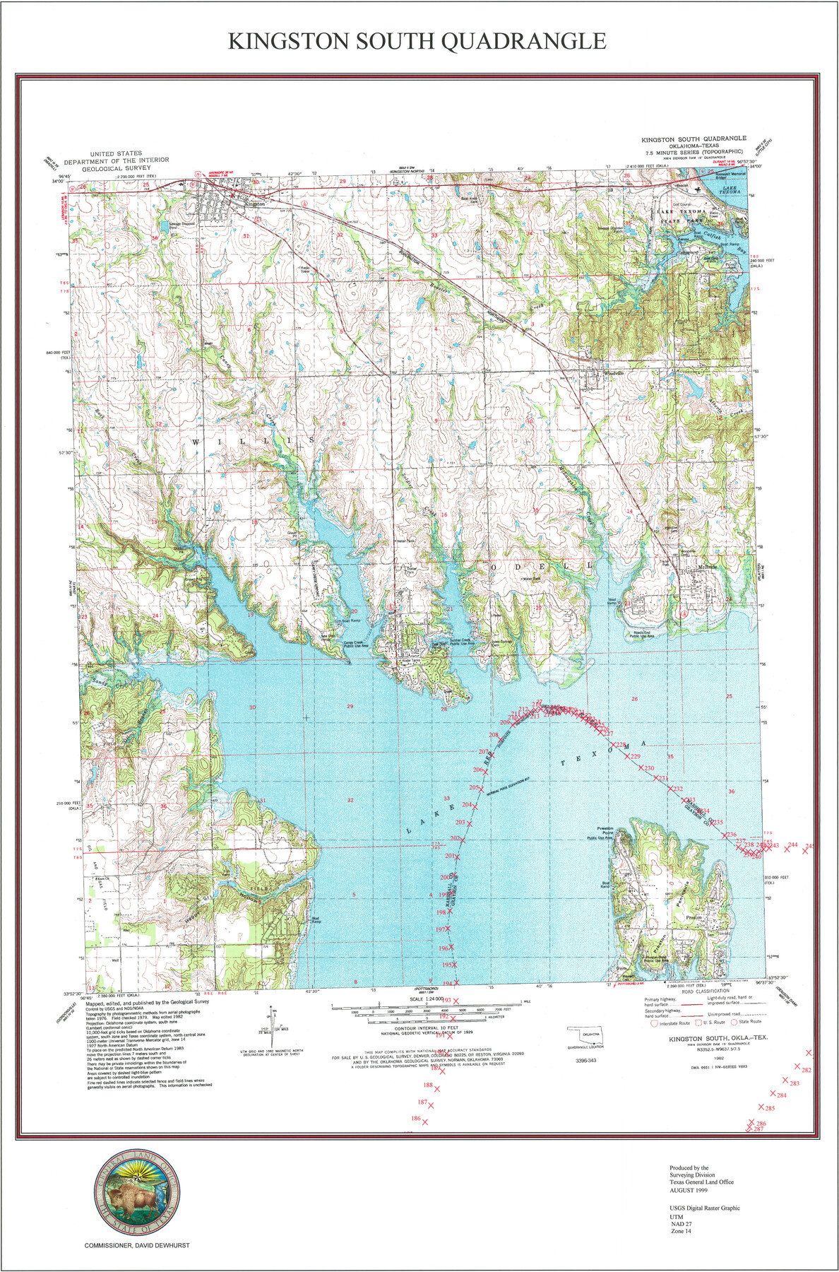
Kingston South Quadrangle
USGS Topo Sheet showing plotted Texoma Area Boundary
-
Map/Doc
97364
-
Collection
General Map Collection
-
Object Dates
8/1999 (Creation Date)
-
Counties
Grayson
-
Subjects
Texas Boundaries Topographic
-
Height x Width
35.4 x 23.4 inches
89.9 x 59.4 cm
-
Comments
See Texas State Boundary Line 7 (75018) and Texas State Boundary Line 10 (97431) for copies of the Texoma Area Boundary Agreement.
Related maps
Texas State Boundary Line 7

Print $182.00
Texas State Boundary Line 7
2000
Size 11.2 x 8.8 inches
Map/Doc 75018
Texas State Boundary Line 8

Print $170.00
Texas State Boundary Line 8
2000
Size 11.3 x 8.8 inches
Map/Doc 75054
Texas State Boundary Line 9

Print $174.00
Texas State Boundary Line 9
2000
Size 11.3 x 8.8 inches
Map/Doc 75076
Lebanon Quadrangle

Print $20.00
- Digital $50.00
Lebanon Quadrangle
1999
Size 35.4 x 23.4 inches
Map/Doc 97360
Dexter Quadrangle

Print $20.00
- Digital $50.00
Dexter Quadrangle
1999
Size 35.4 x 23.4 inches
Map/Doc 97361
Gordonville Quadrangle

Print $20.00
- Digital $50.00
Gordonville Quadrangle
1999
Size 35.4 x 23.4 inches
Map/Doc 97362
Pottsboro Quadrangle

Print $20.00
- Digital $50.00
Pottsboro Quadrangle
1999
Size 35.4 x 23.4 inches
Map/Doc 97363
Platter Quadrangle

Print $20.00
- Digital $50.00
Platter Quadrangle
1999
Size 35.4 x 23.4 inches
Map/Doc 97365
Denison Dam Quadrangle

Print $20.00
- Digital $50.00
Denison Dam Quadrangle
1999
Size 35.4 x 23.4 inches
Map/Doc 97366

Part of: General Map Collection
Crosby County Sketch File 33

Print $20.00
- Digital $50.00
Crosby County Sketch File 33
1954
Size 30.9 x 37.1 inches
Map/Doc 10354
Wilson County Boundary File 3

Print $26.00
- Digital $50.00
Wilson County Boundary File 3
Size 14.3 x 8.7 inches
Map/Doc 60083
Brewster County Sketch File N-20

Print $40.00
- Digital $50.00
Brewster County Sketch File N-20
1941
Size 16.5 x 20.5 inches
Map/Doc 10967
Flight Mission No. BQR-5K, Frame 68, Brazoria County

Print $20.00
- Digital $50.00
Flight Mission No. BQR-5K, Frame 68, Brazoria County
1952
Size 18.8 x 22.5 inches
Map/Doc 84013
Guadalupe County Working Sketch 3

Print $20.00
- Digital $50.00
Guadalupe County Working Sketch 3
1980
Size 17.1 x 16.5 inches
Map/Doc 63312
Andrews County Sketch File 5

Print $4.00
- Digital $50.00
Andrews County Sketch File 5
1936
Size 11.8 x 8.8 inches
Map/Doc 12823
Old Miscellaneous File 38

Print $40.00
- Digital $50.00
Old Miscellaneous File 38
Size 58.2 x 33.7 inches
Map/Doc 75283
Ellis County Boundary File 1

Print $10.00
- Digital $50.00
Ellis County Boundary File 1
Size 12.5 x 7.7 inches
Map/Doc 52939
Brewster County Working Sketch 34

Print $20.00
- Digital $50.00
Brewster County Working Sketch 34
1943
Size 33.7 x 21.2 inches
Map/Doc 67568
Harris County Sketch File 66

Print $20.00
- Digital $50.00
Harris County Sketch File 66
Size 16.9 x 27.5 inches
Map/Doc 11661
Terrell County Rolled Sketch 32

Print $20.00
- Digital $50.00
Terrell County Rolled Sketch 32
Size 20.6 x 25.4 inches
Map/Doc 7938
Llano County Working Sketch 2

Print $20.00
- Digital $50.00
Llano County Working Sketch 2
1949
Size 21.0 x 24.3 inches
Map/Doc 70620
You may also like
Flight Mission No. DQN-2K, Frame 93, Calhoun County

Print $20.00
- Digital $50.00
Flight Mission No. DQN-2K, Frame 93, Calhoun County
1953
Size 16.5 x 16.2 inches
Map/Doc 84283
Eastland County Working Sketch 20

Print $20.00
- Digital $50.00
Eastland County Working Sketch 20
1920
Size 38.0 x 23.5 inches
Map/Doc 68801
Swisher County

Print $20.00
- Digital $50.00
Swisher County
1879
Size 21.1 x 18.4 inches
Map/Doc 4064
Henderson County Rolled Sketch 11

Print $20.00
- Digital $50.00
Henderson County Rolled Sketch 11
1915
Size 29.4 x 42.4 inches
Map/Doc 75950

Newton County Rolled Sketch 19

Print $20.00
- Digital $50.00
Newton County Rolled Sketch 19
1956
Size 42.1 x 33.5 inches
Map/Doc 6848
Montgomery County Working Sketch 41

Print $20.00
- Digital $50.00
Montgomery County Working Sketch 41
1955
Size 22.9 x 23.6 inches
Map/Doc 71148
Comal County Working Sketch 14

Print $40.00
- Digital $50.00
Comal County Working Sketch 14
1992
Size 25.4 x 49.9 inches
Map/Doc 68180
[Blocks K3, K4, K7, K8, K14, M7, east part of Leagues]
![90592, [Blocks K3, K4, K7, K8, K14, M7, east part of Leagues], Twichell Survey Records](https://historictexasmaps.com/wmedia_w700/maps/90592-1.tif.jpg)
Print $20.00
- Digital $50.00
[Blocks K3, K4, K7, K8, K14, M7, east part of Leagues]
Size 33.4 x 31.8 inches
Map/Doc 90592
[Surveying sketch of J.C. Payne, J.D. Polk, Jos. English, et al in Travis County, Texas]
![75801, [Surveying sketch of J.C. Payne, J.D. Polk, Jos. English, et al in Travis County, Texas], Maddox Collection](https://historictexasmaps.com/wmedia_w700/maps/75801.tif.jpg)
Print $20.00
- Digital $50.00
[Surveying sketch of J.C. Payne, J.D. Polk, Jos. English, et al in Travis County, Texas]
Size 18.3 x 23.5 inches
Map/Doc 75801
Terry County Rolled Sketch 7

Print $20.00
- Digital $50.00
Terry County Rolled Sketch 7
1903
Size 19.6 x 19.9 inches
Map/Doc 7981
Pecos County Rolled Sketch 82

Print $20.00
- Digital $50.00
Pecos County Rolled Sketch 82
1930
Size 29.0 x 26.4 inches
Map/Doc 10192