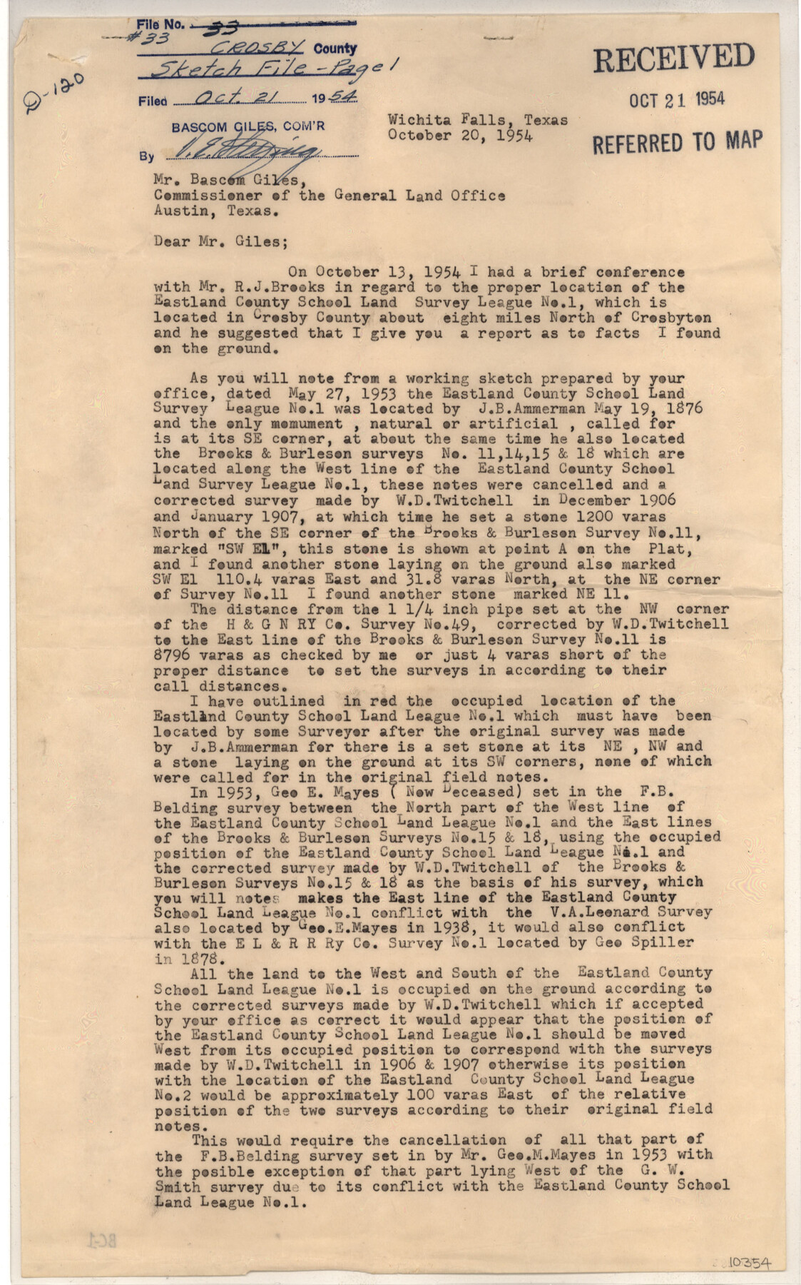
Crosby County Sketch File 33
[Sketch and report of a resurvey of Eastland County School Land League No. 1]
-
Map/Doc
10354
-
Collection
General Map Collection
-
Object Dates
5/21/1954 (Creation Date)
10/21/1954 (File Date)
-
People and Organizations
Ross Corlett (Surveyor/Engineer)
-
Counties
Crosby
-
Subjects
Surveying Sketch File
-
Height x Width
30.9 x 37.1 inches
78.5 x 94.2 cm
-
Medium
multi-page, multi-format
-
Comments
See letter to Ross Corlett Nov. 3, 1954
Part of: General Map Collection
Potter County Sketch File 6

Print $20.00
- Digital $50.00
Potter County Sketch File 6
1900
Size 34.4 x 29.0 inches
Map/Doc 10575
Sketch of a portion of the Texas Coast showing the relative positions of different harbours with the interior Military Posts, and the roads communicating with them, also two new routes from Black Point and Lamar to San Antonio

Print $20.00
- Digital $50.00
Sketch of a portion of the Texas Coast showing the relative positions of different harbours with the interior Military Posts, and the roads communicating with them, also two new routes from Black Point and Lamar to San Antonio
1855
Size 27.2 x 18.3 inches
Map/Doc 72711
Haskell County Sketch File 3

Print $8.00
- Digital $50.00
Haskell County Sketch File 3
Size 9.8 x 8.8 inches
Map/Doc 26121
[Gulf, Colorado & Santa Fe]
![64574, [Gulf, Colorado & Santa Fe], General Map Collection](https://historictexasmaps.com/wmedia_w700/maps/64574.tif.jpg)
Print $40.00
- Digital $50.00
[Gulf, Colorado & Santa Fe]
Size 32.8 x 126.0 inches
Map/Doc 64574
Moore County Working Sketch 12

Print $20.00
- Digital $50.00
Moore County Working Sketch 12
1952
Size 33.1 x 28.4 inches
Map/Doc 71194
Wise County Working Sketch 29

Print $20.00
- Digital $50.00
Wise County Working Sketch 29
1997
Size 22.3 x 26.8 inches
Map/Doc 72643
Jefferson County Rolled Sketch 45

Print $20.00
- Digital $50.00
Jefferson County Rolled Sketch 45
1959
Size 31.2 x 27.3 inches
Map/Doc 6402
Flight Mission No. DAG-21K, Frame 40, Matagorda County

Print $20.00
- Digital $50.00
Flight Mission No. DAG-21K, Frame 40, Matagorda County
1952
Size 18.6 x 19.3 inches
Map/Doc 86407
Nueces County Sketch File 37

Print $2.00
- Digital $50.00
Nueces County Sketch File 37
1913
Size 11.2 x 8.6 inches
Map/Doc 32614
Jefferson County Working Sketch 40

Print $40.00
- Digital $50.00
Jefferson County Working Sketch 40
1985
Size 58.9 x 42.2 inches
Map/Doc 66584
Wichita County Sketch File 23

Print $20.00
- Digital $50.00
Wichita County Sketch File 23
1911
Size 32.8 x 29.4 inches
Map/Doc 10432
Brazoria County Rolled Sketch 34

Print $20.00
- Digital $50.00
Brazoria County Rolled Sketch 34
1944
Size 29.8 x 18.3 inches
Map/Doc 5171
You may also like
Bailey County Rolled Sketch RSH

Print $20.00
- Digital $50.00
Bailey County Rolled Sketch RSH
1907
Size 34.3 x 23.3 inches
Map/Doc 5112
San Jacinto County Boundary File 1a

Print $58.00
- Digital $50.00
San Jacinto County Boundary File 1a
Size 14.5 x 8.9 inches
Map/Doc 58551
Fort Bend Co.

Print $20.00
- Digital $50.00
Fort Bend Co.
1931
Size 39.1 x 40.8 inches
Map/Doc 73150
Flight Mission No. BRE-4P, Frame 167, Nueces County

Print $20.00
- Digital $50.00
Flight Mission No. BRE-4P, Frame 167, Nueces County
1956
Size 18.6 x 22.5 inches
Map/Doc 86830
Jones County Boundary File 1

Print $78.00
- Digital $50.00
Jones County Boundary File 1
1882
Size 10.7 x 8.2 inches
Map/Doc 55633
Map of Kyle, Lockhart & Southern Ry.

Print $40.00
- Digital $50.00
Map of Kyle, Lockhart & Southern Ry.
1882
Size 14.5 x 94.9 inches
Map/Doc 64285
Gregg County School Land League 2

Print $20.00
- Digital $50.00
Gregg County School Land League 2
Size 16.4 x 17.7 inches
Map/Doc 90614
Brewster County Rolled Sketch C

Print $40.00
- Digital $50.00
Brewster County Rolled Sketch C
Size 39.0 x 71.8 inches
Map/Doc 8466
Houston & Texas Central Railway Through Bastrop County

Print $40.00
- Digital $50.00
Houston & Texas Central Railway Through Bastrop County
1916
Size 21.3 x 116.5 inches
Map/Doc 64418
Lipscomb County Working Sketch 2

Print $20.00
- Digital $50.00
Lipscomb County Working Sketch 2
1959
Size 33.4 x 36.6 inches
Map/Doc 70578
Crockett County Rolled Sketch 49

Print $20.00
- Digital $50.00
Crockett County Rolled Sketch 49
1940
Size 32.8 x 42.7 inches
Map/Doc 8713
Galveston Harbor, Texas

Print $20.00
- Digital $50.00
Galveston Harbor, Texas
1882
Size 15.0 x 19.5 inches
Map/Doc 97281