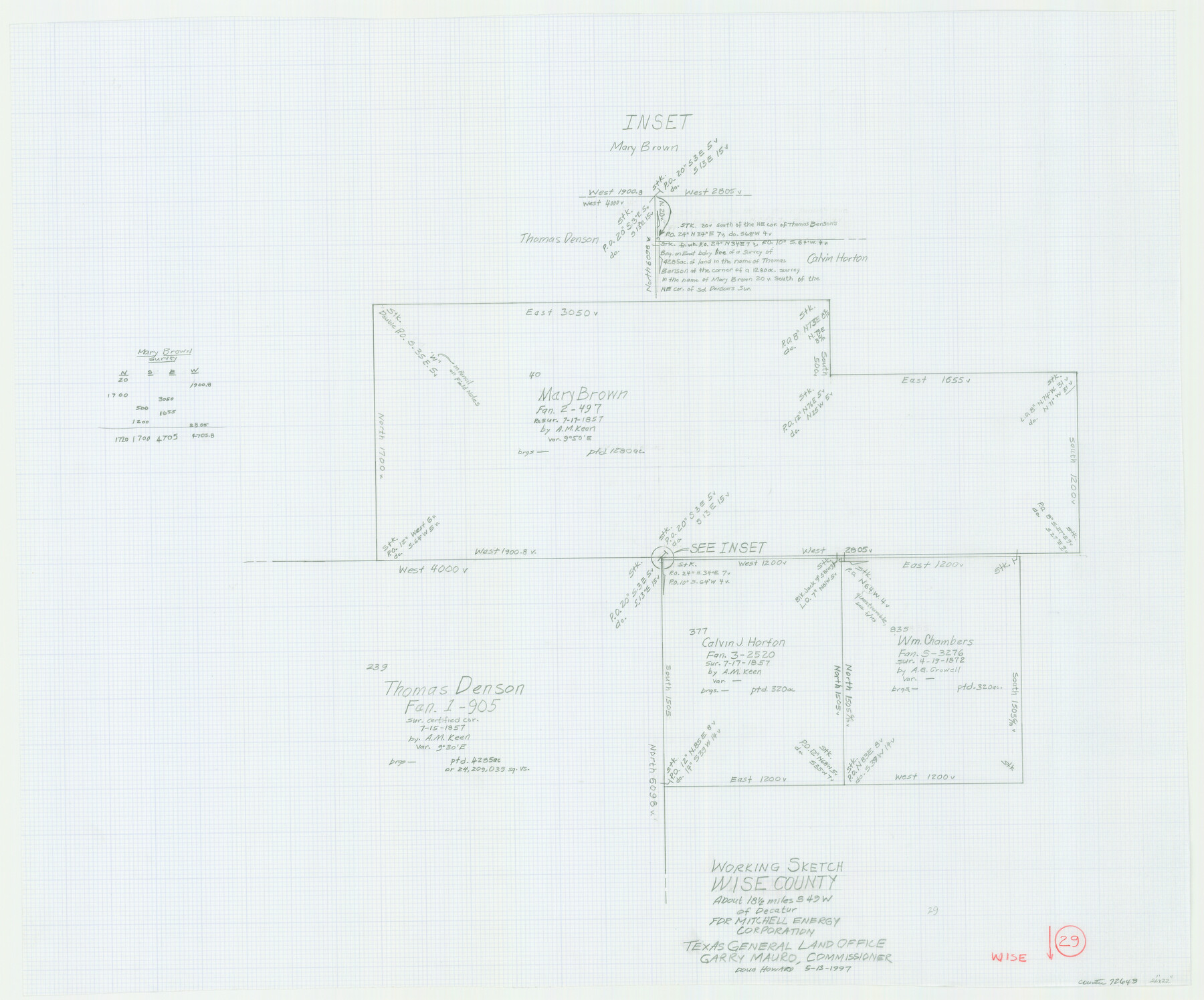
Wise County Working Sketch 29
-
Map/Doc
72643
-
Collection
General Map Collection
-
Object Dates
5/13/1997 (Creation Date)
-
People and Organizations
Douglas Howard (Draftsman)
-
Counties
Wise
-
Subjects
Surveying Working Sketch
-
Height x Width
22.3 x 26.8 inches
56.6 x 68.1 cm
Part of: General Map Collection
Eastland County Working Sketch 22

Print $20.00
- Digital $50.00
Eastland County Working Sketch 22
1920
Size 19.9 x 19.2 inches
Map/Doc 68803
Webb County Working Sketch 12

Print $20.00
- Digital $50.00
Webb County Working Sketch 12
1921
Size 15.9 x 14.6 inches
Map/Doc 72377
Fractional Township No. 7 South Range No. 15 East of the Indian Meridian, Indian Territory

Print $20.00
- Digital $50.00
Fractional Township No. 7 South Range No. 15 East of the Indian Meridian, Indian Territory
1896
Size 19.2 x 24.3 inches
Map/Doc 75226
Terrell County Sketch File 23

Print $10.00
- Digital $50.00
Terrell County Sketch File 23
1932
Size 14.3 x 8.9 inches
Map/Doc 37954
Galveston Entrance

Print $20.00
- Digital $50.00
Galveston Entrance
1856
Size 16.4 x 20.3 inches
Map/Doc 69857

[Sketch for Mineral Application 24072, San Jacinto River]
![65599, [Sketch for Mineral Application 24072, San Jacinto River], General Map Collection](https://historictexasmaps.com/wmedia_w700/maps/65599.tif.jpg)
Print $20.00
- Digital $50.00
[Sketch for Mineral Application 24072, San Jacinto River]
1929
Size 23.5 x 18.0 inches
Map/Doc 65599
Henderson County

Print $40.00
- Digital $50.00
Henderson County
1988
Size 30.8 x 63.0 inches
Map/Doc 77310
Terry County Rolled Sketch 6

Print $20.00
- Digital $50.00
Terry County Rolled Sketch 6
1944
Size 36.5 x 43.7 inches
Map/Doc 9996
Brewster County Sketch File A

Print $40.00
- Digital $50.00
Brewster County Sketch File A
1910
Size 18.6 x 19.9 inches
Map/Doc 10974
Maps of Gulf Intracoastal Waterway, Texas - Sabine River to the Rio Grande and connecting waterways including ship channels

Print $20.00
- Digital $50.00
Maps of Gulf Intracoastal Waterway, Texas - Sabine River to the Rio Grande and connecting waterways including ship channels
1966
Size 14.6 x 22.3 inches
Map/Doc 61956

You may also like
Pecos County Working Sketch 45

Print $20.00
- Digital $50.00
Pecos County Working Sketch 45
1946
Size 20.8 x 26.7 inches
Map/Doc 71517
Val Verde County Working Sketch 58

Print $20.00
- Digital $50.00
Val Verde County Working Sketch 58
1958
Size 21.0 x 22.8 inches
Map/Doc 72193
Brazoria County Rolled Sketch 25

Print $40.00
- Digital $50.00
Brazoria County Rolled Sketch 25
1935
Size 50.8 x 33.5 inches
Map/Doc 8928
Lampasas County Boundary File 5

Print $16.00
- Digital $50.00
Lampasas County Boundary File 5
Size 11.1 x 8.7 inches
Map/Doc 56128
Pecos County Working Sketch 21

Print $20.00
- Digital $50.00
Pecos County Working Sketch 21
1925
Size 27.3 x 29.0 inches
Map/Doc 71491
Sulphur River, Harts Bluff Sheet

Print $3.00
- Digital $50.00
Sulphur River, Harts Bluff Sheet
1919
Size 13.1 x 18.0 inches
Map/Doc 78329
Val Verde County Sketch File 43

Print $20.00
- Digital $50.00
Val Verde County Sketch File 43
1938
Size 24.8 x 32.3 inches
Map/Doc 12585
Coleman County Sketch File 3

Print $4.00
- Digital $50.00
Coleman County Sketch File 3
1857
Size 9.5 x 8.1 inches
Map/Doc 18670
Pecos County Working Sketch 54

Print $20.00
- Digital $50.00
Pecos County Working Sketch 54
1948
Size 26.0 x 24.1 inches
Map/Doc 71526
Dimmit County Sketch File 31

Print $20.00
- Digital $50.00
Dimmit County Sketch File 31
1894
Size 12.7 x 17.3 inches
Map/Doc 11352
Jeff Davis County Working Sketch 9

Print $20.00
- Digital $50.00
Jeff Davis County Working Sketch 9
1943
Size 28.5 x 27.3 inches
Map/Doc 66504
Jeff Davis County Working Sketch 29

Print $20.00
- Digital $50.00
Jeff Davis County Working Sketch 29
1967
Size 25.8 x 41.6 inches
Map/Doc 66524