Ellis County Boundary File 1
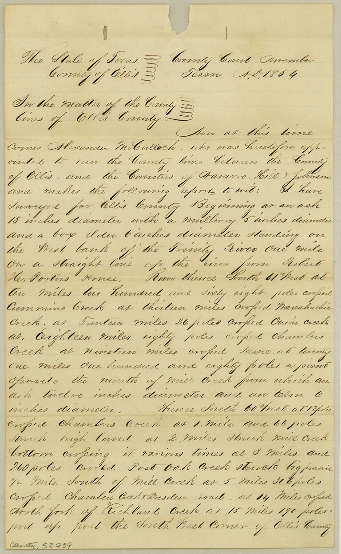
[Surveyor's Report and Fieldnotes of Ellis County Boundary Lines]
-
Map/Doc
52939
-
Collection
General Map Collection
-
Counties
Ellis
-
Subjects
County Boundaries
-
Height x Width
12.5 x 7.7 inches
31.8 x 19.6 cm
Part of: General Map Collection
Grayson County Fannin District

Print $20.00
- Digital $50.00
Grayson County Fannin District
1885
Size 40.1 x 37.7 inches
Map/Doc 4961
Cooke County Working Sketch 1

Print $20.00
- Digital $50.00
Cooke County Working Sketch 1
Size 16.5 x 28.3 inches
Map/Doc 68238
Schleicher County Working Sketch 17

Print $20.00
- Digital $50.00
Schleicher County Working Sketch 17
1946
Size 21.8 x 23.1 inches
Map/Doc 63819
Austin County Sketch File 10

Print $40.00
- Digital $50.00
Austin County Sketch File 10
1895
Size 25.5 x 21.0 inches
Map/Doc 10875
Red River County Sketch File 20

Print $4.00
- Digital $50.00
Red River County Sketch File 20
Size 8.2 x 10.1 inches
Map/Doc 35152
[Sketch for Mineral Application 26543 - Sabine River, D. H. Sanford]
![65677, [Sketch for Mineral Application 26543 - Sabine River, D. H. Sanford], General Map Collection](https://historictexasmaps.com/wmedia_w700/maps/65677.tif.jpg)
Print $40.00
- Digital $50.00
[Sketch for Mineral Application 26543 - Sabine River, D. H. Sanford]
1931
Size 30.8 x 71.9 inches
Map/Doc 65677
Zavala County Sketch File 45

Print $4.00
- Digital $50.00
Zavala County Sketch File 45
1923
Size 11.5 x 8.8 inches
Map/Doc 41428
Brewster County Rolled Sketch 33

Print $20.00
- Digital $50.00
Brewster County Rolled Sketch 33
1906
Size 20.5 x 29.0 inches
Map/Doc 5217
Duval County Rolled Sketch 51

Print $20.00
- Digital $50.00
Duval County Rolled Sketch 51
Size 19.1 x 16.9 inches
Map/Doc 5765
Jack County Working Sketch Graphic Index

Print $20.00
- Digital $50.00
Jack County Working Sketch Graphic Index
1925
Size 45.4 x 37.3 inches
Map/Doc 76589
Cottle County Sketch File 5

Print $6.00
- Digital $50.00
Cottle County Sketch File 5
1883
Size 17.0 x 9.6 inches
Map/Doc 19474
Hopkins County Rolled Sketch 28

Print $20.00
- Digital $50.00
Hopkins County Rolled Sketch 28
Size 25.3 x 19.9 inches
Map/Doc 6225
You may also like
Tom Green County Working Sketch Graphic Index

Print $40.00
- Digital $50.00
Tom Green County Working Sketch Graphic Index
1942
Size 70.9 x 40.1 inches
Map/Doc 76715
Crockett County Rolled Sketch 42

Print $20.00
- Digital $50.00
Crockett County Rolled Sketch 42
Size 24.4 x 24.7 inches
Map/Doc 5592
Eastland County Working Sketch 62

Print $20.00
- Digital $50.00
Eastland County Working Sketch 62
1989
Size 20.7 x 28.0 inches
Map/Doc 68843
Flight Mission No. BRE-1P, Frame 45, Nueces County

Print $20.00
- Digital $50.00
Flight Mission No. BRE-1P, Frame 45, Nueces County
1956
Size 16.5 x 16.1 inches
Map/Doc 86634
Garza County Rolled Sketch 6

Print $53.00
- Digital $50.00
Garza County Rolled Sketch 6
Size 43.6 x 30.0 inches
Map/Doc 9052

Somervell County Rolled Sketch B

Print $20.00
- Digital $50.00
Somervell County Rolled Sketch B
Size 18.8 x 19.9 inches
Map/Doc 7792
The Republic County of Austin. Defined, May 24, 1838

Print $20.00
The Republic County of Austin. Defined, May 24, 1838
2020
Size 14.7 x 21.6 inches
Map/Doc 96082
Kinney County Sketch File 30

Print $10.00
- Digital $50.00
Kinney County Sketch File 30
1933
Size 11.3 x 8.7 inches
Map/Doc 29171
Sutton County Working Sketch 23

Print $20.00
- Digital $50.00
Sutton County Working Sketch 23
1981
Size 17.3 x 27.1 inches
Map/Doc 62366
Aransas County Sketch File 9

Print $40.00
- Digital $50.00
Aransas County Sketch File 9
Size 17.5 x 19.8 inches
Map/Doc 10819
Flight Mission No. BRA-9M, Frame 65, Jefferson County

Print $20.00
- Digital $50.00
Flight Mission No. BRA-9M, Frame 65, Jefferson County
1953
Size 18.6 x 22.2 inches
Map/Doc 85648