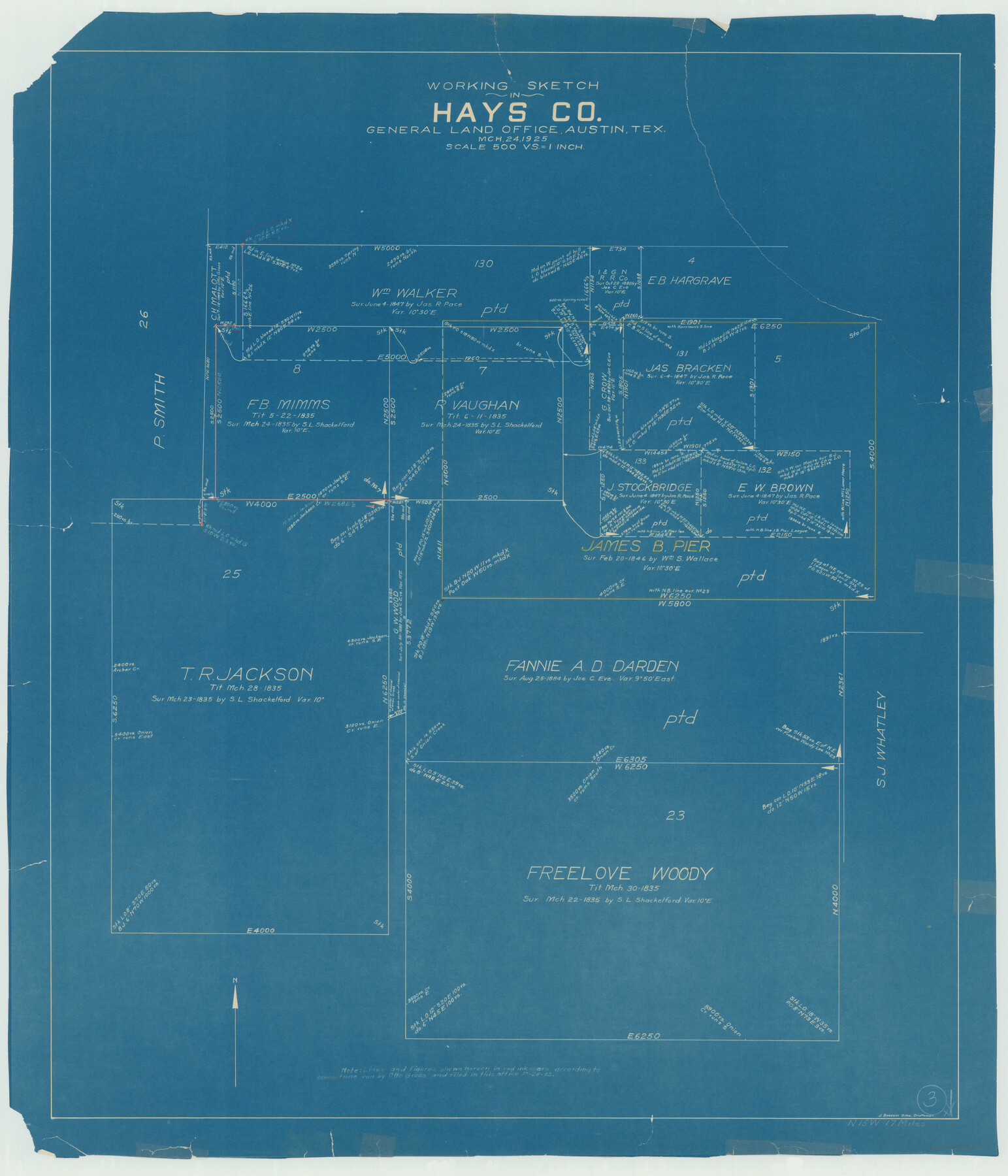
Hays County Working Sketch 3
-
Map/Doc
66077
-
Collection
General Map Collection
-
Object Dates
3/24/1925 (Creation Date)
-
People and Organizations
J. Bascom Giles (Draftsman)
-
Counties
Hays
-
Subjects
Surveying Working Sketch
-
Height x Width
28.2 x 24.1 inches
71.6 x 61.2 cm
-
Scale
1" = 500 varas
Part of: General Map Collection

Knox County Sketch File 22

Print $6.00
- Digital $50.00
Knox County Sketch File 22
1931
Size 11.2 x 8.8 inches
Map/Doc 29251
Upton County Rolled Sketch 20

Print $40.00
- Digital $50.00
Upton County Rolled Sketch 20
1933
Size 53.0 x 36.8 inches
Map/Doc 10041
Flight Mission No. DQN-1K, Frame 123, Calhoun County

Print $20.00
- Digital $50.00
Flight Mission No. DQN-1K, Frame 123, Calhoun County
1953
Size 18.4 x 22.2 inches
Map/Doc 84189
Winkler County Rolled Sketch 10

Print $40.00
- Digital $50.00
Winkler County Rolled Sketch 10
1958
Size 29.4 x 55.9 inches
Map/Doc 10151
Goliad County Working Sketch 7

Print $20.00
- Digital $50.00
Goliad County Working Sketch 7
1937
Size 35.0 x 32.9 inches
Map/Doc 63197
Morris County Rolled Sketch 2A

Print $20.00
- Digital $50.00
Morris County Rolled Sketch 2A
Size 24.0 x 18.7 inches
Map/Doc 10260
Culberson County Rolled Sketch 63

Print $20.00
- Digital $50.00
Culberson County Rolled Sketch 63
1986
Size 19.4 x 24.3 inches
Map/Doc 5679
Loving County Working Sketch 5

Print $20.00
- Digital $50.00
Loving County Working Sketch 5
1946
Size 29.7 x 39.0 inches
Map/Doc 70637
Brewster County Rolled Sketch 38A

Print $20.00
- Digital $50.00
Brewster County Rolled Sketch 38A
Size 15.6 x 14.1 inches
Map/Doc 5219
Sterling County Rolled Sketch 10

Print $20.00
- Digital $50.00
Sterling County Rolled Sketch 10
1939
Size 24.2 x 31.2 inches
Map/Doc 7846
Stonewall County Boundary File 3a

Print $68.00
- Digital $50.00
Stonewall County Boundary File 3a
Size 14.4 x 9.0 inches
Map/Doc 58970
You may also like
Brewster County Sketch File N-22

Print $40.00
- Digital $50.00
Brewster County Sketch File N-22
Size 12.4 x 21.4 inches
Map/Doc 10969
Newton County Rolled Sketch 23
Print $20.00
- Digital $50.00
Newton County Rolled Sketch 23
1893
Size 22.7 x 18.5 inches
Map/Doc 6850
United States - Gulf Coast - Padre I. and Laguna Madre Lat. 27° 12' to Lat. 26° 33' Texas

Print $20.00
- Digital $50.00
United States - Gulf Coast - Padre I. and Laguna Madre Lat. 27° 12' to Lat. 26° 33' Texas
1913
Size 27.0 x 18.2 inches
Map/Doc 72814

[State Capitol Leagues and County School Leagues]
![92475, [State Capitol Leagues and County School Leagues], Twichell Survey Records](https://historictexasmaps.com/wmedia_w700/maps/92475-1.tif.jpg)
Print $20.00
- Digital $50.00
[State Capitol Leagues and County School Leagues]
Size 19.4 x 11.8 inches
Map/Doc 92475
Howard County Working Sketch 10

Print $20.00
- Digital $50.00
Howard County Working Sketch 10
1962
Size 24.4 x 26.1 inches
Map/Doc 66278
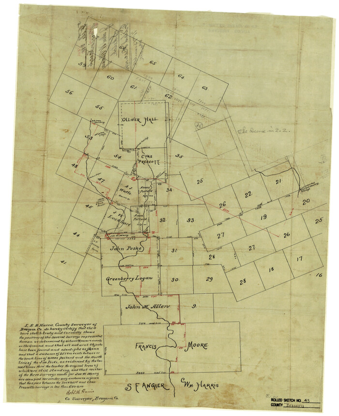
Brazoria County Rolled Sketch 43
Print $20.00
- Digital $50.00
Brazoria County Rolled Sketch 43
Size 24.4 x 19.6 inches
Map/Doc 5177
Matagorda County NRC Article 33.136 Location Key Sheet

Print $20.00
- Digital $50.00
Matagorda County NRC Article 33.136 Location Key Sheet
1995
Size 27.0 x 23.0 inches
Map/Doc 87909
Kimble County Working Sketch 19

Print $20.00
- Digital $50.00
Kimble County Working Sketch 19
1926
Size 38.7 x 34.8 inches
Map/Doc 70087
Map of the Reconnaissance in Texas by Lieuts Blake & Meade of the Corps of Topl. Engrs.

Print $20.00
- Digital $50.00
Map of the Reconnaissance in Texas by Lieuts Blake & Meade of the Corps of Topl. Engrs.
1845
Size 27.7 x 18.2 inches
Map/Doc 72893
Map of Madison County

Print $20.00
- Digital $50.00
Map of Madison County
1858
Size 19.8 x 31.7 inches
Map/Doc 3834
Angelina County Working Sketch 16

Print $20.00
- Digital $50.00
Angelina County Working Sketch 16
1935
Size 31.0 x 27.0 inches
Map/Doc 67097