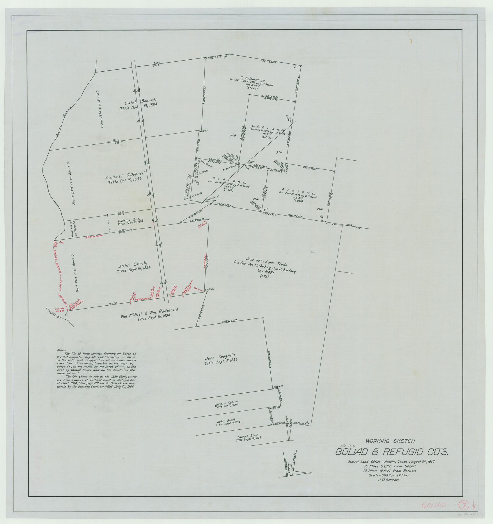
Goliad County Working Sketch 7
-
Map/Doc
63197
-
Collection
General Map Collection
-
Object Dates
8/24/1937 (Creation Date)
-
People and Organizations
J.O. Barrow (Draftsman)
-
Counties
Goliad Refugio
-
Subjects
Surveying Working Sketch
-
Height x Width
35.0 x 32.9 inches
88.9 x 83.6 cm
-
Scale
1" = 500 varas
Part of: General Map Collection
Leon County Rolled Sketch 25

Print $20.00
- Digital $50.00
Leon County Rolled Sketch 25
Size 47.3 x 36.2 inches
Map/Doc 9434

Callahan County Sketch File 11

Print $64.00
- Digital $50.00
Callahan County Sketch File 11
Size 11.4 x 8.4 inches
Map/Doc 35887
Eastland County Working Sketch 61

Print $20.00
- Digital $50.00
Eastland County Working Sketch 61
1989
Size 35.4 x 41.0 inches
Map/Doc 68842
Flight Mission No. BRA-7M, Frame 87, Jefferson County

Print $20.00
- Digital $50.00
Flight Mission No. BRA-7M, Frame 87, Jefferson County
1953
Size 18.5 x 22.3 inches
Map/Doc 85509
Map of San Antonio, Texas, Postal Delivery Units showing all boundary lines / Tourist Map of San Antonio showing points of interest and places of amusements, main thoroughfares and highways in and out of city and where they go / Business Section Map

Map of San Antonio, Texas, Postal Delivery Units showing all boundary lines / Tourist Map of San Antonio showing points of interest and places of amusements, main thoroughfares and highways in and out of city and where they go / Business Section Map
Size 18.0 x 24.0 inches
Map/Doc 95160
Copy of Surveyor's Field Book, Morris Browning - In Blocks 7, 5 & 4, I&GNRRCo., Hutchinson and Carson Counties, Texas

Print $3.00
- Digital $50.00
Copy of Surveyor's Field Book, Morris Browning - In Blocks 7, 5 & 4, I&GNRRCo., Hutchinson and Carson Counties, Texas
1888
Size 12.7 x 9.7 inches
Map/Doc 62258
Flight Mission No. BRA-6M, Frame 90, Jefferson County

Print $20.00
- Digital $50.00
Flight Mission No. BRA-6M, Frame 90, Jefferson County
1953
Size 18.5 x 22.2 inches
Map/Doc 85433
Polk County Sketch File 10

Print $4.00
- Digital $50.00
Polk County Sketch File 10
Size 5.2 x 6.4 inches
Map/Doc 34140
King County Working Sketch 17

Print $40.00
- Digital $50.00
King County Working Sketch 17
1979
Size 32.2 x 59.3 inches
Map/Doc 70181
Limestone County Working Sketch Graphic Index

Print $20.00
- Digital $50.00
Limestone County Working Sketch Graphic Index
1971
Size 47.8 x 32.9 inches
Map/Doc 76621
Matagorda County Sketch File 7

Print $20.00
- Digital $50.00
Matagorda County Sketch File 7
1890
Size 37.3 x 24.6 inches
Map/Doc 12038
You may also like
Newton County Rolled Sketch 20

Print $40.00
- Digital $50.00
Newton County Rolled Sketch 20
1956
Size 41.4 x 48.0 inches
Map/Doc 9581
Brewster County

Print $20.00
- Digital $50.00
Brewster County
1920
Size 24.4 x 19.5 inches
Map/Doc 3330
A Map of that part of Young District south of old Fannin District line

Print $20.00
- Digital $50.00
A Map of that part of Young District south of old Fannin District line
1861
Size 24.9 x 38.0 inches
Map/Doc 1979
Brown County Working Sketch 17

Print $20.00
- Digital $50.00
Brown County Working Sketch 17
1993
Size 25.6 x 29.4 inches
Map/Doc 67782
Flight Mission No. CRC-3R, Frame 40, Chambers County

Print $20.00
- Digital $50.00
Flight Mission No. CRC-3R, Frame 40, Chambers County
1956
Size 18.6 x 22.3 inches
Map/Doc 84813

Newton County Sketch File 40

Print $6.00
- Digital $50.00
Newton County Sketch File 40
Size 16.2 x 10.6 inches
Map/Doc 32419
Trinity River, McKinney Sheet/East Fork of Trinity River

Print $20.00
- Digital $50.00
Trinity River, McKinney Sheet/East Fork of Trinity River
1931
Size 40.6 x 28.0 inches
Map/Doc 65241
Val Verde County Working Sketch 20

Print $20.00
- Digital $50.00
Val Verde County Working Sketch 20
1929
Size 30.5 x 20.2 inches
Map/Doc 72155
Flight Mission No. CLL-3N, Frame 35, Willacy County

Print $20.00
- Digital $50.00
Flight Mission No. CLL-3N, Frame 35, Willacy County
1954
Size 18.3 x 22.1 inches
Map/Doc 87093
Brewster County Sketch File N-20

Print $40.00
- Digital $50.00
Brewster County Sketch File N-20
1941
Size 16.5 x 20.5 inches
Map/Doc 10967
Harris County Working Sketch 2

Print $20.00
- Digital $50.00
Harris County Working Sketch 2
Size 32.3 x 31.7 inches
Map/Doc 65894