Newton County Rolled Sketch 20
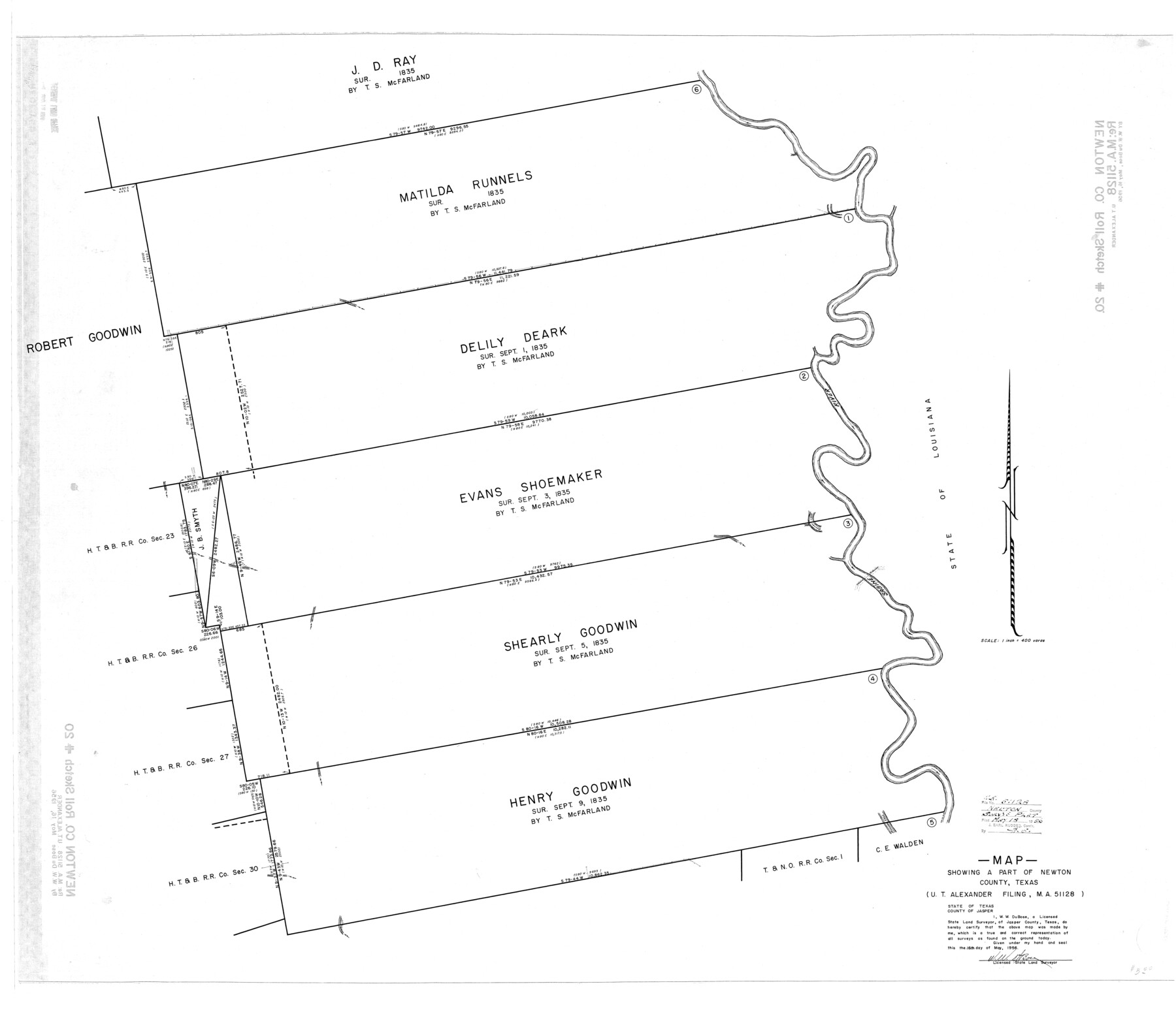
Map showing a part of Newton County, Texas (U.T. Alexander filing, MA-51128)
-
Map/Doc
9581
-
Collection
General Map Collection
-
Object Dates
1956/5/16 (Creation Date)
1956/5/18 (File Date)
-
People and Organizations
W.W. DuBose (Surveyor/Engineer)
-
Counties
Newton
-
Subjects
Surveying Rolled Sketch
-
Height x Width
41.4 x 48.0 inches
105.2 x 121.9 cm
-
Scale
1" = 400 varas
Part of: General Map Collection
Williamson County Sketch File 19

Print $24.00
- Digital $50.00
Williamson County Sketch File 19
Size 12.8 x 8.0 inches
Map/Doc 40345
Pecos County Working Sketch Graphic index - northwest part - sheet A

Print $20.00
- Digital $50.00
Pecos County Working Sketch Graphic index - northwest part - sheet A
1975
Size 42.2 x 42.6 inches
Map/Doc 76663
Carte du Mexique et de la Floride des Terres Angloises et des Isles Antilles du Cours et des Environs de la Riviere Mississipi

Print $20.00
- Digital $50.00
Carte du Mexique et de la Floride des Terres Angloises et des Isles Antilles du Cours et des Environs de la Riviere Mississipi
1703
Size 21.8 x 30.0 inches
Map/Doc 94852
Corpus Christi Bay, Texas

Print $40.00
- Digital $50.00
Corpus Christi Bay, Texas
1867
Size 33.9 x 54.8 inches
Map/Doc 73470
Jackson County Rolled Sketch 3

Print $20.00
- Digital $50.00
Jackson County Rolled Sketch 3
1913
Size 23.9 x 24.2 inches
Map/Doc 6336
Brazos River, Millican Sheet

Print $6.00
- Digital $50.00
Brazos River, Millican Sheet
1936
Size 30.1 x 31.6 inches
Map/Doc 65278
Flight Mission No. CUG-1P, Frame 166, Kleberg County

Print $20.00
- Digital $50.00
Flight Mission No. CUG-1P, Frame 166, Kleberg County
1956
Size 18.8 x 22.4 inches
Map/Doc 86173
Brazoria County Rolled Sketch 18B

Print $20.00
- Digital $50.00
Brazoria County Rolled Sketch 18B
1914
Size 10.0 x 17.3 inches
Map/Doc 5165
Culberson County Rolled Sketch 54

Print $40.00
- Digital $50.00
Culberson County Rolled Sketch 54
1968
Size 59.0 x 29.4 inches
Map/Doc 10300
San Augustine County Rolled Sketch 3

Print $20.00
- Digital $50.00
San Augustine County Rolled Sketch 3
1969
Size 21.5 x 29.0 inches
Map/Doc 7555
Presidio County Rolled Sketch 50

Print $20.00
- Digital $50.00
Presidio County Rolled Sketch 50
Size 21.2 x 18.4 inches
Map/Doc 7344
Sketch B Showing the progress of Section No. 2

Print $20.00
- Digital $50.00
Sketch B Showing the progress of Section No. 2
1844
Size 25.3 x 27.7 inches
Map/Doc 97204
You may also like
Starr County Boundary File 1

Print $24.00
- Digital $50.00
Starr County Boundary File 1
Size 13.0 x 8.5 inches
Map/Doc 58801
Flight Mission No. BQR-20K, Frame 11, Brazoria County

Print $20.00
- Digital $50.00
Flight Mission No. BQR-20K, Frame 11, Brazoria County
1952
Size 18.7 x 22.3 inches
Map/Doc 84113
Floyd County Boundary File 1

Print $30.00
- Digital $50.00
Floyd County Boundary File 1
Size 8.9 x 4.2 inches
Map/Doc 53445
Flight Mission No. CUG-2P, Frame 85, Kleberg County

Print $20.00
- Digital $50.00
Flight Mission No. CUG-2P, Frame 85, Kleberg County
1956
Size 18.5 x 22.2 inches
Map/Doc 86217
General Highway Map. Detail of Cities and Towns in Travis County, Texas. City Map, Austin and vicinity, Travis County, Texas

Print $20.00
General Highway Map. Detail of Cities and Towns in Travis County, Texas. City Map, Austin and vicinity, Travis County, Texas
1961
Size 18.2 x 25.0 inches
Map/Doc 79685
Platte (sic) of the unorganized County School Lands in the District of Young

Print $20.00
- Digital $50.00
Platte (sic) of the unorganized County School Lands in the District of Young
Size 16.0 x 12.3 inches
Map/Doc 90447
Matagorda County Rolled Sketch 35

Print $20.00
- Digital $50.00
Matagorda County Rolled Sketch 35
1903
Size 18.6 x 38.0 inches
Map/Doc 6696
Hidalgo County Sketch File 11

Print $40.00
- Digital $50.00
Hidalgo County Sketch File 11
1908
Size 18.5 x 13.6 inches
Map/Doc 26429
Kimble County Rolled Sketch 15

Print $59.00
- Digital $50.00
Kimble County Rolled Sketch 15
1886
Size 28.3 x 42.1 inches
Map/Doc 6508

Hidalgo County Sketch File 12

Print $20.00
- Digital $50.00
Hidalgo County Sketch File 12
Size 16.3 x 25.1 inches
Map/Doc 11763
Dimmit County Sketch File 19

Print $28.00
- Digital $50.00
Dimmit County Sketch File 19
1886
Size 13.4 x 8.8 inches
Map/Doc 21088