Floyd County Boundary File 1
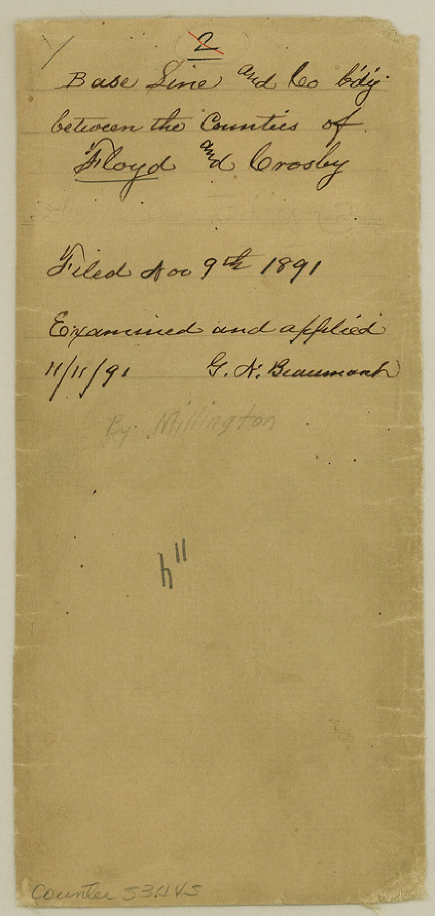
Base Line and County b'd'y between the Counties of Floyd and Crosley
-
Map/Doc
53445
-
Collection
General Map Collection
-
Counties
Floyd
-
Subjects
County Boundaries
-
Height x Width
8.9 x 4.2 inches
22.6 x 10.7 cm
Part of: General Map Collection
Crosby County Sketch File 22

Print $22.00
- Digital $50.00
Crosby County Sketch File 22
1912
Size 11.3 x 8.6 inches
Map/Doc 20090
Texas, Mexico and part of the United States compiled from the latest and best authorities

Print $20.00
- Digital $50.00
Texas, Mexico and part of the United States compiled from the latest and best authorities
1836
Size 9.1 x 11.0 inches
Map/Doc 95958
Live Oak County Boundary File 60b

Print $10.00
- Digital $50.00
Live Oak County Boundary File 60b
Size 12.8 x 8.3 inches
Map/Doc 56416
[Atchison, Topeka & Santa Fe from Paisano to south of Plata]
![64709, [Atchison, Topeka & Santa Fe from Paisano to south of Plata], General Map Collection](https://historictexasmaps.com/wmedia_w700/maps/64709.tif.jpg)
Print $40.00
- Digital $50.00
[Atchison, Topeka & Santa Fe from Paisano to south of Plata]
Size 32.3 x 120.8 inches
Map/Doc 64709
Flight Mission No. DAG-17K, Frame 76, Matagorda County

Print $20.00
- Digital $50.00
Flight Mission No. DAG-17K, Frame 76, Matagorda County
1952
Size 16.6 x 16.6 inches
Map/Doc 86335
Louisiana and Texas Intracoastal Waterway

Print $20.00
- Digital $50.00
Louisiana and Texas Intracoastal Waterway
1937
Size 13.7 x 19.6 inches
Map/Doc 83348
Runnels County Boundary File 1a

Print $14.00
- Digital $50.00
Runnels County Boundary File 1a
Size 12.9 x 8.4 inches
Map/Doc 58507
Dimmit County Sketch File 61

Print $12.00
- Digital $50.00
Dimmit County Sketch File 61
1999
Size 11.4 x 8.8 inches
Map/Doc 21208
Dickens County Sketch File 23

Print $6.00
- Digital $50.00
Dickens County Sketch File 23
1914
Size 12.4 x 8.4 inches
Map/Doc 20990
Potter County Working Sketch 9

Print $40.00
- Digital $50.00
Potter County Working Sketch 9
1966
Size 46.4 x 48.6 inches
Map/Doc 71669
Hutchinson County Rolled Sketch 37A

Print $40.00
- Digital $50.00
Hutchinson County Rolled Sketch 37A
1950
Size 24.7 x 50.5 inches
Map/Doc 9246
Gaines County Boundary File 3

Print $5.00
- Digital $50.00
Gaines County Boundary File 3
Size 13.9 x 9.1 inches
Map/Doc 53654
You may also like
Madison County Working Sketch 15

Print $20.00
- Digital $50.00
Madison County Working Sketch 15
2009
Size 42.3 x 36.0 inches
Map/Doc 89019
Orange County Sketch File 14a

Print $4.00
- Digital $50.00
Orange County Sketch File 14a
1886
Size 8.1 x 10.2 inches
Map/Doc 33328
Sabine Pass, Series No. 519

Print $20.00
- Digital $50.00
Sabine Pass, Series No. 519
1888
Size 27.3 x 21.6 inches
Map/Doc 69841
Hudspeth County Rolled Sketch 52

Print $20.00
- Digital $50.00
Hudspeth County Rolled Sketch 52
1975
Size 27.2 x 21.6 inches
Map/Doc 6257
Gray County Rolled Sketch A

Print $20.00
- Digital $50.00
Gray County Rolled Sketch A
1888
Size 40.4 x 40.8 inches
Map/Doc 9008
Galveston Bay and Approaches

Print $20.00
- Digital $50.00
Galveston Bay and Approaches
1946
Size 45.5 x 34.0 inches
Map/Doc 69876
Hardin County Rolled Sketch 15

Print $20.00
- Digital $50.00
Hardin County Rolled Sketch 15
1938
Size 30.9 x 23.7 inches
Map/Doc 6084
Reconnaissance of Aransas Pass, Texas

Print $20.00
- Digital $50.00
Reconnaissance of Aransas Pass, Texas
1852
Size 14.4 x 13.6 inches
Map/Doc 76171
Liberty County Sketch File 37a

Print $6.00
- Digital $50.00
Liberty County Sketch File 37a
1895
Size 15.1 x 11.5 inches
Map/Doc 29981
[Jas. T. Williams Survey and vicinity]
![91264, [Jas. T. Williams Survey and vicinity], Twichell Survey Records](https://historictexasmaps.com/wmedia_w700/maps/91264-1.tif.jpg)
Print $20.00
- Digital $50.00
[Jas. T. Williams Survey and vicinity]
Size 15.0 x 12.0 inches
Map/Doc 91264
Smith County Working Sketch 9

Print $40.00
- Digital $50.00
Smith County Working Sketch 9
1947
Size 48.8 x 44.2 inches
Map/Doc 63894
[Sketch showing Blocks 1, B18 and E.L. & RR. Co. Blocks 2, 8 and 97]
![89950, [Sketch showing Blocks 1, B18 and E.L. & RR. Co. Blocks 2, 8 and 97], Twichell Survey Records](https://historictexasmaps.com/wmedia_w700/maps/89950-1.tif.jpg)
Print $40.00
- Digital $50.00
[Sketch showing Blocks 1, B18 and E.L. & RR. Co. Blocks 2, 8 and 97]
Size 55.1 x 44.9 inches
Map/Doc 89950