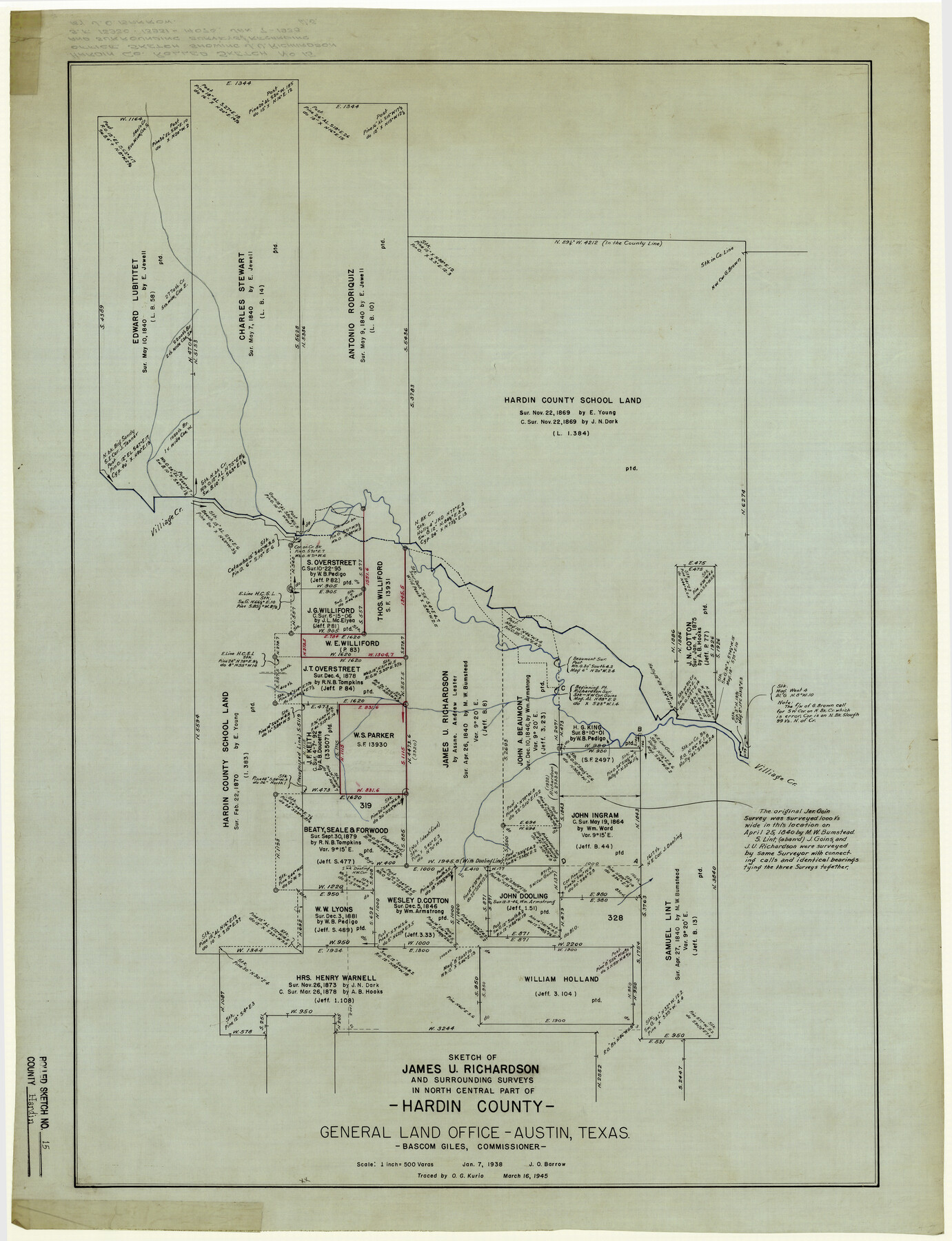
Hardin County Rolled Sketch 15
Sketch of James U. Richardson and surrounding surveys in north central part of Hardin County
-
Map/Doc
6084
-
Collection
General Map Collection
-
Object Dates
1/7/1938 (Creation Date)
3/16/1945 (Copy/Tracing Date)
-
People and Organizations
J.O. Barrow (Draftsman)
Otto G. Kurio (Draftsman)
-
Counties
Hardin
-
Subjects
Surveying Rolled Sketch
-
Height x Width
30.9 x 23.7 inches
78.5 x 60.2 cm
-
Medium
linen, manuscript
-
Scale
1" = 500 varas
Part of: General Map Collection
Chase & Bachelder's American Museum of Art

Print $20.00
- Digital $50.00
Chase & Bachelder's American Museum of Art
1875
Size 37.4 x 28.0 inches
Map/Doc 97495
Hutchinson County

Print $20.00
- Digital $50.00
Hutchinson County
1898
Size 41.8 x 37.6 inches
Map/Doc 66875
La Salle County Working Sketch 19

Print $20.00
- Digital $50.00
La Salle County Working Sketch 19
1941
Size 24.6 x 31.4 inches
Map/Doc 70320
Parker County

Print $20.00
- Digital $50.00
Parker County
1942
Size 45.7 x 37.8 inches
Map/Doc 66972
Schleicher County Rolled Sketch 16

Print $20.00
- Digital $50.00
Schleicher County Rolled Sketch 16
Size 27.4 x 29.0 inches
Map/Doc 7758
Lamb County Sketch File 5

Print $20.00
- Digital $50.00
Lamb County Sketch File 5
Size 23.3 x 31.1 inches
Map/Doc 11971
Galveston County NRC Article 33.136 Sketch 17

Print $22.00
- Digital $50.00
Galveston County NRC Article 33.136 Sketch 17
2002
Size 24.1 x 36.4 inches
Map/Doc 78584
Glasscock County Rolled Sketch VS

Print $20.00
- Digital $50.00
Glasscock County Rolled Sketch VS
Size 20.6 x 35.3 inches
Map/Doc 6022
Gregg County Sketch File 6

Print $10.00
- Digital $50.00
Gregg County Sketch File 6
1931
Size 11.2 x 8.8 inches
Map/Doc 24577
Donley County Working Sketch 6

Print $20.00
- Digital $50.00
Donley County Working Sketch 6
1965
Size 34.3 x 42.2 inches
Map/Doc 68739
Flight Mission No. DAG-24K, Frame 48, Matagorda County

Print $20.00
- Digital $50.00
Flight Mission No. DAG-24K, Frame 48, Matagorda County
1953
Size 18.5 x 22.1 inches
Map/Doc 86535
Map showing survey for proposed ship channel from Brownsville to Brazos Santiago Pass

Print $20.00
- Digital $50.00
Map showing survey for proposed ship channel from Brownsville to Brazos Santiago Pass
1912
Size 18.4 x 28.4 inches
Map/Doc 72900
You may also like
Clay County Boundary File 17

Print $8.00
- Digital $50.00
Clay County Boundary File 17
Size 13.8 x 8.4 inches
Map/Doc 51432
Reagan County

Print $40.00
- Digital $50.00
Reagan County
1940
Size 50.8 x 41.2 inches
Map/Doc 95621
Galveston Bay and Approaches

Print $20.00
- Digital $50.00
Galveston Bay and Approaches
1938
Size 45.4 x 34.6 inches
Map/Doc 69875
[Sections 58 through 95]
![92478, [Sections 58 through 95], Twichell Survey Records](https://historictexasmaps.com/wmedia_w700/maps/92478-1.tif.jpg)
Print $20.00
- Digital $50.00
[Sections 58 through 95]
Size 23.9 x 19.5 inches
Map/Doc 92478
Crane County Sketch File 3c

Print $6.00
- Digital $50.00
Crane County Sketch File 3c
1884
Size 12.8 x 7.9 inches
Map/Doc 19559
Map of Jack County

Print $20.00
- Digital $50.00
Map of Jack County
1895
Size 47.6 x 38.0 inches
Map/Doc 4988
Archer County Boundary File 2

Print $92.00
- Digital $50.00
Archer County Boundary File 2
Size 14.4 x 8.4 inches
Map/Doc 50086
Buchanan Dam Reservoir Clearing

Print $20.00
- Digital $50.00
Buchanan Dam Reservoir Clearing
1935
Size 21.8 x 40.4 inches
Map/Doc 60393
Arroyo Colorado, La Feria Sheet

Print $40.00
- Digital $50.00
Arroyo Colorado, La Feria Sheet
1929
Size 24.6 x 58.5 inches
Map/Doc 65128
Township 9 South Range 13 West, South Western District, Louisiana

Print $20.00
- Digital $50.00
Township 9 South Range 13 West, South Western District, Louisiana
1858
Size 19.8 x 24.8 inches
Map/Doc 65852
Scurry County North Snyder Area

Print $20.00
- Digital $50.00
Scurry County North Snyder Area
1949
Size 32.7 x 23.6 inches
Map/Doc 92920
Hood County Working Sketch 7

Print $20.00
- Digital $50.00
Hood County Working Sketch 7
1970
Size 29.4 x 31.2 inches
Map/Doc 66201