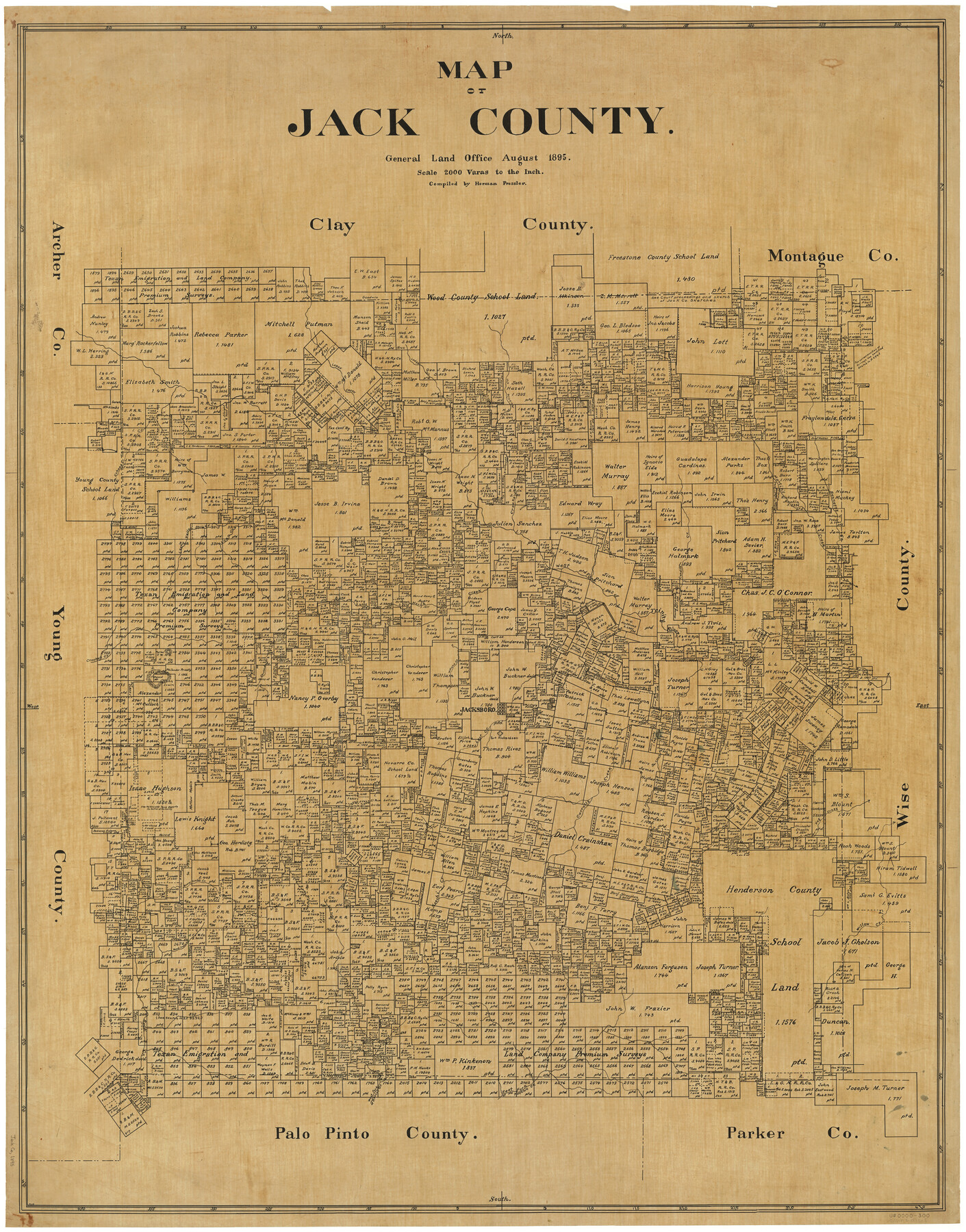
Map of Jack County
-
Map/Doc
4988
-
Collection
General Map Collection
-
Object Dates
8/1895 (Creation Date)
-
People and Organizations
Texas General Land Office (Publisher)
Herman Pressler (Compiler)
-
Counties
Jack
-
Subjects
County
-
Height x Width
47.6 x 38.0 inches
120.9 x 96.5 cm
Part of: General Map Collection
Flight Mission No. DAG-21K, Frame 39, Matagorda County

Print $20.00
- Digital $50.00
Flight Mission No. DAG-21K, Frame 39, Matagorda County
1952
Size 18.6 x 22.3 inches
Map/Doc 86406

Garza County Working Sketch 14

Print $20.00
- Digital $50.00
Garza County Working Sketch 14
1957
Size 24.3 x 35.0 inches
Map/Doc 63161
Childress County Rolled Sketch 16A

Print $20.00
- Digital $50.00
Childress County Rolled Sketch 16A
Size 44.3 x 36.9 inches
Map/Doc 8599
Harris County Working Sketch 45

Print $20.00
- Digital $50.00
Harris County Working Sketch 45
1942
Size 26.6 x 31.9 inches
Map/Doc 65937
Hartley County Boundary File 3a

Print $42.00
- Digital $50.00
Hartley County Boundary File 3a
Size 8.6 x 22.0 inches
Map/Doc 54483
Flight Mission No. DCL-7C, Frame 77, Kenedy County

Print $20.00
- Digital $50.00
Flight Mission No. DCL-7C, Frame 77, Kenedy County
1943
Size 15.3 x 15.2 inches
Map/Doc 86063
Jasper County Sketch File 21

Print $4.00
- Digital $50.00
Jasper County Sketch File 21
Size 13.4 x 8.9 inches
Map/Doc 27820
Outer Continental Shelf Leasing Maps (Louisiana Offshore Operations)

Print $20.00
- Digital $50.00
Outer Continental Shelf Leasing Maps (Louisiana Offshore Operations)
1955
Size 15.9 x 10.8 inches
Map/Doc 76082
Jeff Davis County Rolled Sketch 43

Print $20.00
- Digital $50.00
Jeff Davis County Rolled Sketch 43
2002
Size 24.2 x 24.4 inches
Map/Doc 78648
[Right of Way & Track Map, The Texas & Pacific Ry. Co. Main Line]
![64660, [Right of Way & Track Map, The Texas & Pacific Ry. Co. Main Line], General Map Collection](https://historictexasmaps.com/wmedia_w700/maps/64660.tif.jpg)
Print $20.00
- Digital $50.00
[Right of Way & Track Map, The Texas & Pacific Ry. Co. Main Line]
Size 11.0 x 18.6 inches
Map/Doc 64660
Sutton County Working Sketch 6

Print $20.00
- Digital $50.00
Sutton County Working Sketch 6
1972
Size 39.3 x 37.4 inches
Map/Doc 62349
You may also like

Cass County Working Sketch 8

Print $20.00
- Digital $50.00
Cass County Working Sketch 8
1937
Size 20.2 x 16.1 inches
Map/Doc 67911
Kinney County Rolled Sketch 17

Print $20.00
- Digital $50.00
Kinney County Rolled Sketch 17
1965
Size 18.4 x 21.5 inches
Map/Doc 6544
Eastland County Sketch File 2

Print $26.00
- Digital $50.00
Eastland County Sketch File 2
Size 8.1 x 7.9 inches
Map/Doc 21559
Culberson County Sketch File 1c

Print $4.00
- Digital $50.00
Culberson County Sketch File 1c
1859
Size 7.4 x 8.0 inches
Map/Doc 20111
Lynn County Sketch File 2

Print $5.00
- Digital $50.00
Lynn County Sketch File 2
1902
Size 11.6 x 17.1 inches
Map/Doc 30447
Cooke County Sketch File 22

Print $6.00
- Digital $50.00
Cooke County Sketch File 22
1870
Size 6.4 x 8.2 inches
Map/Doc 19267
[Strickland Survey Sketch Showing Abercrombie Corner, Exhibit C]
![91370, [Strickland Survey Sketch Showing Abercrombie Corner, Exhibit C], Twichell Survey Records](https://historictexasmaps.com/wmedia_w700/maps/91370-1.tif.jpg)
Print $20.00
- Digital $50.00
[Strickland Survey Sketch Showing Abercrombie Corner, Exhibit C]
Size 25.3 x 19.1 inches
Map/Doc 91370
Real County Working Sketch 60

Print $40.00
- Digital $50.00
Real County Working Sketch 60
1963
Size 60.4 x 41.1 inches
Map/Doc 71952
Flight Mission No. CUG-2P, Frame 26, Kleberg County

Print $20.00
- Digital $50.00
Flight Mission No. CUG-2P, Frame 26, Kleberg County
1956
Size 18.7 x 22.4 inches
Map/Doc 86190
Concho County Rolled Sketch 12

Print $40.00
- Digital $50.00
Concho County Rolled Sketch 12
1958
Size 36.4 x 50.6 inches
Map/Doc 8657
Cass County Rolled Sketch OPD

Print $20.00
- Digital $50.00
Cass County Rolled Sketch OPD
1936
Size 29.4 x 25.1 inches
Map/Doc 5483