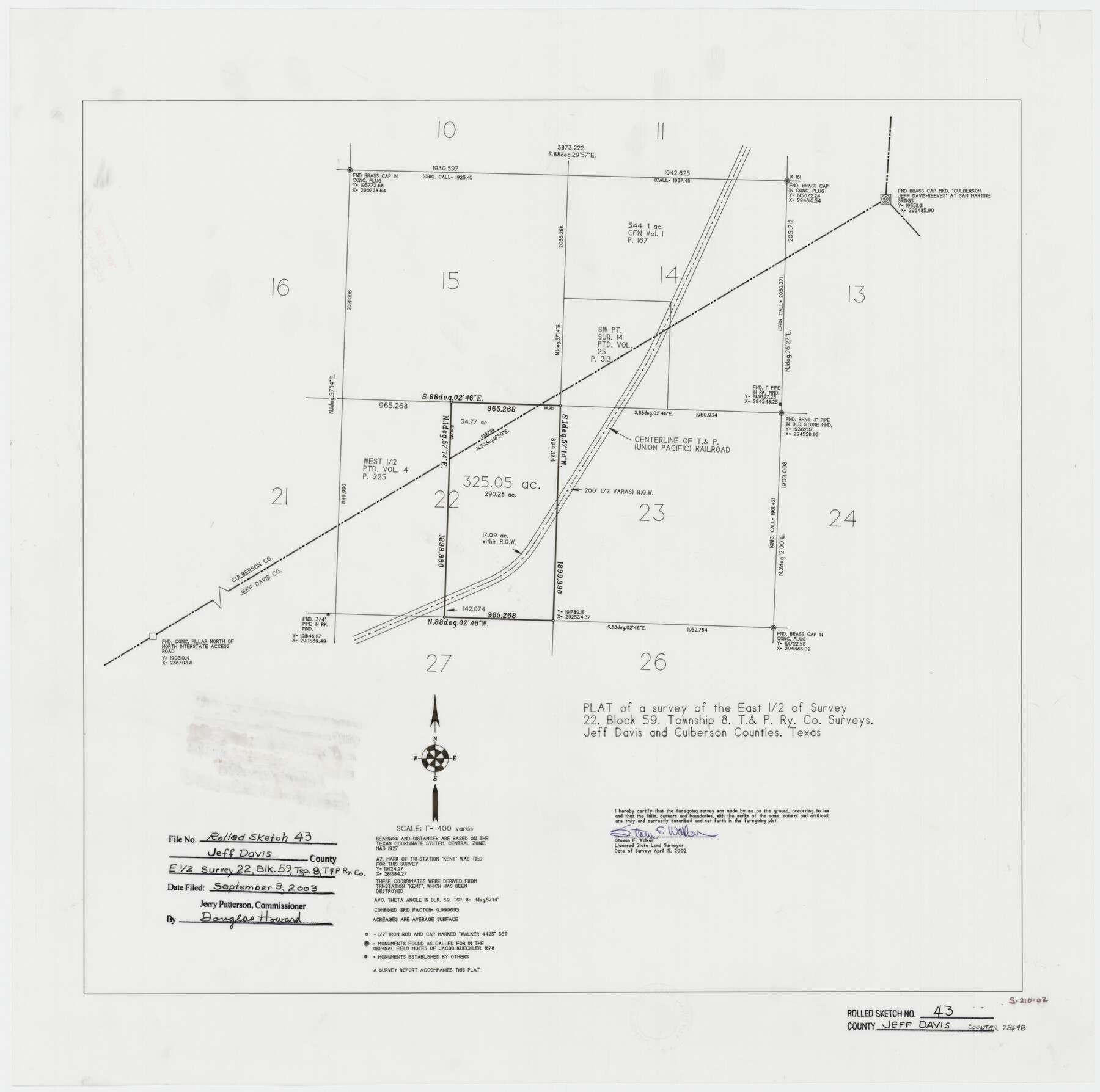
Jeff Davis County Rolled Sketch 43
Plat of a survey of the east 1/2 of survey 22, Block 59, Township 8, T. & P. Ry. Co. surveys, Jeff Davis and Culberson Counties, Texas
-
Map/Doc
78648
-
Collection
General Map Collection
-
Object Dates
2002/4/15 (Creation Date)
2003/9/3 (File Date)
-
People and Organizations
Steven F. Walker (Surveyor/Engineer)
-
Counties
Jeff Davis Culberson
-
Subjects
Surveying Rolled Sketch
-
Height x Width
24.2 x 24.4 inches
61.5 x 62.0 cm
-
Medium
mylar, print
-
Scale
1" = 400 varas
-
Comments
See Jeff Davis County Sketch File 48 (82923) for report.
Related maps
Jeff Davis County Sketch File 48

Print $3.00
- Digital $50.00
Jeff Davis County Sketch File 48
2002
Size 14.0 x 8.5 inches
Map/Doc 82923
Part of: General Map Collection
[Fragment, Jefferson Plotted]
![78352, [Fragment, Jefferson Plotted], General Map Collection](https://historictexasmaps.com/wmedia_w700/maps/78352.tif.jpg)
Print $2.00
- Digital $50.00
[Fragment, Jefferson Plotted]
Size 14.0 x 7.5 inches
Map/Doc 78352
Padre Island National Seashore, Texas - Dependent Resurvey

Print $4.00
- Digital $50.00
Padre Island National Seashore, Texas - Dependent Resurvey
2001
Size 18.3 x 24.2 inches
Map/Doc 60546
Wheeler County Working Sketch 5

Print $40.00
- Digital $50.00
Wheeler County Working Sketch 5
1972
Size 55.3 x 45.9 inches
Map/Doc 72494
Frio County Rolled Sketch HM2

Print $20.00
- Digital $50.00
Frio County Rolled Sketch HM2
1935
Size 41.3 x 30.6 inches
Map/Doc 8899
Harrison County Sketch File 22

Print $20.00
- Digital $50.00
Harrison County Sketch File 22
1917
Size 24.6 x 23.4 inches
Map/Doc 11695
Map of Houston Co.

Print $40.00
- Digital $50.00
Map of Houston Co.
1896
Size 48.8 x 46.8 inches
Map/Doc 76035
Fort Bend County Sketch File 2a

Print $4.00
- Digital $50.00
Fort Bend County Sketch File 2a
Size 12.7 x 8.1 inches
Map/Doc 22878
Rusk County Sketch File 37

Print $20.00
Rusk County Sketch File 37
1951
Size 23.3 x 26.2 inches
Map/Doc 12275
Yoakum County Sketch File 2

Print $6.00
- Digital $50.00
Yoakum County Sketch File 2
1892
Size 14.5 x 8.5 inches
Map/Doc 40702
Approaches to Galveston Bay

Print $40.00
- Digital $50.00
Approaches to Galveston Bay
1986
Size 36.8 x 54.8 inches
Map/Doc 69886
Harris County Sketch File 61

Print $20.00
- Digital $50.00
Harris County Sketch File 61
1927
Size 19.4 x 16.7 inches
Map/Doc 11659
Cooke County Sketch File 38 1/2

Print $20.00
- Digital $50.00
Cooke County Sketch File 38 1/2
Size 21.5 x 16.6 inches
Map/Doc 11175
You may also like
Upshur County Sketch File 15

Print $20.00
- Digital $50.00
Upshur County Sketch File 15
1934
Size 20.7 x 31.2 inches
Map/Doc 12505

Maps of Gulf Intracoastal Waterway, Texas - Sabine River to the Rio Grande and connecting waterways including ship channels

Print $20.00
- Digital $50.00
Maps of Gulf Intracoastal Waterway, Texas - Sabine River to the Rio Grande and connecting waterways including ship channels
1966
Size 14.6 x 22.2 inches
Map/Doc 61976
[Sketch for Mineral Application 1112 - Colorado River, H. E. Chambers]
![65636, [Sketch for Mineral Application 1112 - Colorado River, H. E. Chambers], General Map Collection](https://historictexasmaps.com/wmedia_w700/maps/65636.tif.jpg)
Print $40.00
- Digital $50.00
[Sketch for Mineral Application 1112 - Colorado River, H. E. Chambers]
1918
Size 48.2 x 26.5 inches
Map/Doc 65636
Clay County Working Sketch 4

Print $20.00
- Digital $50.00
Clay County Working Sketch 4
1923
Size 14.7 x 21.9 inches
Map/Doc 68027
[Map of Texas showing Counties, County Seats, Rivers and Location of State Boundary Line Markers]
![60304, [Map of Texas showing Counties, County Seats, Rivers and Location of State Boundary Line Markers], General Map Collection](https://historictexasmaps.com/wmedia_w700/maps/60304.tif.jpg)
Print $20.00
- Digital $50.00
[Map of Texas showing Counties, County Seats, Rivers and Location of State Boundary Line Markers]
1950
Size 30.2 x 32.9 inches
Map/Doc 60304
Dallam County Sketch File 11

Print $4.00
- Digital $50.00
Dallam County Sketch File 11
1935
Size 11.8 x 7.2 inches
Map/Doc 20377
Brooks County Rolled Sketch 26

Print $20.00
- Digital $50.00
Brooks County Rolled Sketch 26
1945
Size 33.7 x 43.3 inches
Map/Doc 8539
Terry County Boundary File 4

Print $64.00
- Digital $50.00
Terry County Boundary File 4
Size 14.5 x 8.9 inches
Map/Doc 59236
Mapa de los Estados Unidos de Méjico, Segun lo organizado y definido por las varias actas del Congreso de dicha Republica: y construido por las mejores autoridades

Print $20.00
- Digital $50.00
Mapa de los Estados Unidos de Méjico, Segun lo organizado y definido por las varias actas del Congreso de dicha Republica: y construido por las mejores autoridades
1847
Size 31.3 x 42.3 inches
Map/Doc 93878
Cherokee County Working Sketch 13

Print $20.00
- Digital $50.00
Cherokee County Working Sketch 13
1957
Size 46.5 x 43.8 inches
Map/Doc 67968
Scurry County Sketch File 2

Print $4.00
- Digital $50.00
Scurry County Sketch File 2
1888
Size 13.2 x 7.4 inches
Map/Doc 36563