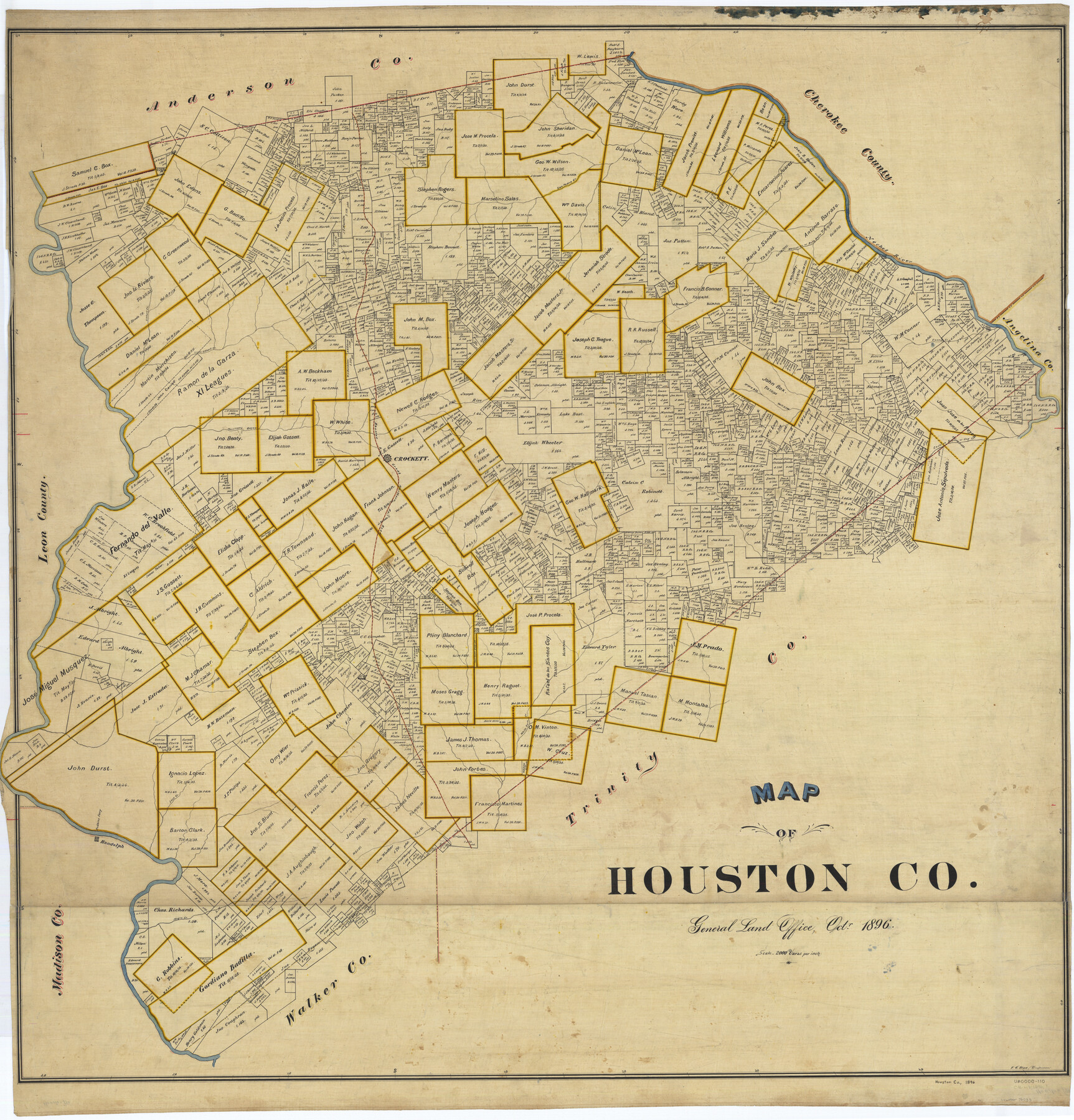
Map of Houston Co.
-
Map/Doc
76035
-
Collection
General Map Collection
-
Object Dates
1896 (Creation Date)
-
People and Organizations
Texas General Land Office (Publisher)
F.G. Blau (Draftsman)
F.G. Blau (Compiler)
-
Counties
Houston
-
Subjects
County
-
Height x Width
48.8 x 46.8 inches
124.0 x 118.9 cm
Part of: General Map Collection
Red River County Sketch File 21

Print $4.00
- Digital $50.00
Red River County Sketch File 21
Size 12.7 x 7.9 inches
Map/Doc 35154
Terrell County Working Sketch 16

Print $40.00
- Digital $50.00
Terrell County Working Sketch 16
1927
Size 37.7 x 51.4 inches
Map/Doc 62165
Hoffman & Walker's Pictorial, Historical Map of Texas

Hoffman & Walker's Pictorial, Historical Map of Texas
1960
Size 44.0 x 45.5 inches
Map/Doc 2122
Gregg County Rolled Sketch 18A

Print $313.00
- Digital $50.00
Gregg County Rolled Sketch 18A
1934
Size 10.5 x 15.5 inches
Map/Doc 45469
Flight Mission No. BRA-16M, Frame 62, Jefferson County

Print $20.00
- Digital $50.00
Flight Mission No. BRA-16M, Frame 62, Jefferson County
1953
Size 18.7 x 22.4 inches
Map/Doc 85679
Ward County Sketch File 9

Print $25.00
- Digital $50.00
Ward County Sketch File 9
1937
Size 10.8 x 8.9 inches
Map/Doc 39623
Official Map of the Highway System of Texas

Digital $50.00
Official Map of the Highway System of Texas
1935
Size 25.1 x 25.9 inches
Map/Doc 93721
San Patricio County Sketch File 51

Print $12.00
- Digital $50.00
San Patricio County Sketch File 51
1917
Size 11.2 x 8.8 inches
Map/Doc 36375
Matagorda County Sketch File 10

Print $26.00
- Digital $50.00
Matagorda County Sketch File 10
Size 8.3 x 5.2 inches
Map/Doc 30755
Atascosa County Sketch File 8

Print $6.00
- Digital $50.00
Atascosa County Sketch File 8
1857
Size 8.7 x 7.7 inches
Map/Doc 13758
Flight Mission No. DCL-4C, Frame 97, Kenedy County

Print $20.00
- Digital $50.00
Flight Mission No. DCL-4C, Frame 97, Kenedy County
1943
Size 18.6 x 22.4 inches
Map/Doc 85818
Flight Mission No. BQR-13K, Frame 28, Brazoria County

Print $20.00
- Digital $50.00
Flight Mission No. BQR-13K, Frame 28, Brazoria County
1952
Size 18.6 x 22.4 inches
Map/Doc 84076
You may also like
[County School Land Leagues]
![90279, [County School Land Leagues], Twichell Survey Records](https://historictexasmaps.com/wmedia_w700/maps/90279-1.tif.jpg)
Print $20.00
- Digital $50.00
[County School Land Leagues]
1913
Size 21.1 x 27.7 inches
Map/Doc 90279
Hamilton County Working Sketch 17

Print $20.00
- Digital $50.00
Hamilton County Working Sketch 17
1951
Size 44.4 x 25.0 inches
Map/Doc 63355
Brewster County Rolled Sketch 140

Print $20.00
- Digital $50.00
Brewster County Rolled Sketch 140
1982
Size 36.5 x 25.1 inches
Map/Doc 5308
Brazoria County State Real Property Sketch 2

Print $60.00
- Digital $50.00
Brazoria County State Real Property Sketch 2
2003
Size 31.0 x 42.9 inches
Map/Doc 83356
Presidio County Sketch File 119

Print $14.00
- Digital $50.00
Presidio County Sketch File 119
1996
Size 14.3 x 9.0 inches
Map/Doc 34927
[Jacob Masters league and those adjoining and Surveys on Elkhart Creek]
![183, [Jacob Masters league and those adjoining and Surveys on Elkhart Creek], General Map Collection](https://historictexasmaps.com/wmedia_w700/maps/183.tif.jpg)
Print $20.00
- Digital $50.00
[Jacob Masters league and those adjoining and Surveys on Elkhart Creek]
1846
Size 20.3 x 8.0 inches
Map/Doc 183
Panola County Working Sketch 22

Print $20.00
- Digital $50.00
Panola County Working Sketch 22
1951
Map/Doc 71431
Little River, Faubion Bridge Sheet

Print $20.00
- Digital $50.00
Little River, Faubion Bridge Sheet
1914
Size 18.5 x 27.6 inches
Map/Doc 69682
Map of Texas with population and location of principal towns and cities according to latest reliable statistics

Print $20.00
- Digital $50.00
Map of Texas with population and location of principal towns and cities according to latest reliable statistics
1912
Size 18.0 x 20.2 inches
Map/Doc 95876
Webb County Sketch File 50-1

Print $8.00
- Digital $50.00
Webb County Sketch File 50-1
1943
Size 14.5 x 8.9 inches
Map/Doc 39833
Flight Mission No. CRC-3R, Frame 20, Chambers County

Print $20.00
- Digital $50.00
Flight Mission No. CRC-3R, Frame 20, Chambers County
1956
Size 18.6 x 22.2 inches
Map/Doc 84794
Wise County Rolled Sketch 7

Print $20.00
- Digital $50.00
Wise County Rolled Sketch 7
Size 23.9 x 18.4 inches
Map/Doc 8281