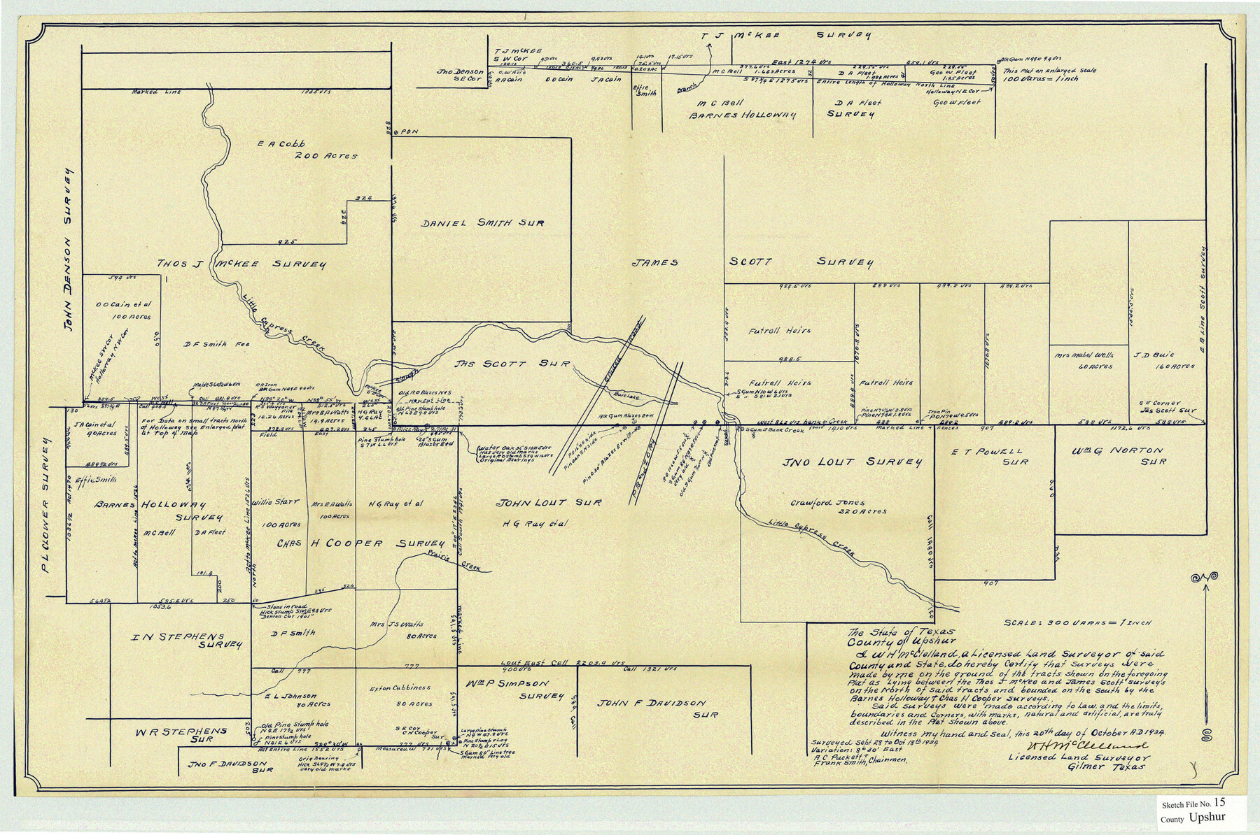
Upshur County Sketch File 15
[Sketch showing the John Lout survey and surrounding area in the southeast corner of the county]
-
Map/Doc
12505
-
Collection
General Map Collection
-
Object Dates
10/20/1934 (Creation Date)
-
People and Organizations
W.H. McClelland (Surveyor/Engineer)
-
Counties
Upshur Gregg
-
Subjects
Surveying Sketch File
-
Height x Width
20.7 x 31.2 inches
52.6 x 79.3 cm
-
Medium
paper, manuscript
-
Scale
1" = 300 varas
-
Features
Little Cypress Creek
Blue Lake
Graded Road
PB&ID RR
Prairie Creek
Part of: General Map Collection
Runnels County Rolled Sketch 49

Print $20.00
- Digital $50.00
Runnels County Rolled Sketch 49
Size 28.8 x 29.1 inches
Map/Doc 7534
Marion County Working Sketch 39

Print $20.00
- Digital $50.00
Marion County Working Sketch 39
1991
Size 20.8 x 19.2 inches
Map/Doc 70815
Collingsworth County

Print $20.00
- Digital $50.00
Collingsworth County
1899
Size 42.7 x 39.7 inches
Map/Doc 4915
Edwards County Sketch File 38

Print $22.00
- Digital $50.00
Edwards County Sketch File 38
1937
Size 11.2 x 8.6 inches
Map/Doc 21773
Map of Ohio, Michigan, Indiana and Kentucky

Print $20.00
- Digital $50.00
Map of Ohio, Michigan, Indiana and Kentucky
1885
Size 12.2 x 9.0 inches
Map/Doc 93520
Calhoun County NRC Article 33.136 Sketch 13

Print $24.00
Calhoun County NRC Article 33.136 Sketch 13
2023
Map/Doc 97272
Mills County Working Sketch 19

Print $20.00
- Digital $50.00
Mills County Working Sketch 19
1963
Size 18.6 x 31.2 inches
Map/Doc 71049
Live Oak County Sketch File 25

Print $16.00
- Digital $50.00
Live Oak County Sketch File 25
1919
Size 9.0 x 8.5 inches
Map/Doc 30301
Supreme Court of the United States, October Term, 1923, No. 15, Original - The State of Oklahoma, Complainant vs. The State of Texas, Defendant, The United States, Intervener; Report of Medial Line Survey

Print $28.00
- Digital $50.00
Supreme Court of the United States, October Term, 1923, No. 15, Original - The State of Oklahoma, Complainant vs. The State of Texas, Defendant, The United States, Intervener; Report of Medial Line Survey
1924
Size 5.9 x 9.1 inches
Map/Doc 3055
Robertson County Working Sketch 15

Print $20.00
- Digital $50.00
Robertson County Working Sketch 15
1984
Size 28.7 x 25.2 inches
Map/Doc 63588
Uvalde County Working Sketch 49

Print $20.00
- Digital $50.00
Uvalde County Working Sketch 49
1980
Size 35.4 x 44.7 inches
Map/Doc 72119
Crane County Working Sketch 20

Print $40.00
- Digital $50.00
Crane County Working Sketch 20
1958
Size 61.8 x 38.1 inches
Map/Doc 68297
You may also like
[West half of Deaf Smith County Map]
![90510, [West half of Deaf Smith County Map], Twichell Survey Records](https://historictexasmaps.com/wmedia_w700/maps/90510-1.tif.jpg)
Print $2.00
- Digital $50.00
[West half of Deaf Smith County Map]
Size 7.6 x 12.5 inches
Map/Doc 90510
Maverick County Working Sketch 14

Print $20.00
- Digital $50.00
Maverick County Working Sketch 14
1970
Size 41.2 x 42.6 inches
Map/Doc 70906
Maverick County Working Sketch 9

Print $20.00
- Digital $50.00
Maverick County Working Sketch 9
1959
Size 43.8 x 42.2 inches
Map/Doc 70901
Lubbock County Working Sketch 4
Print $20.00
- Digital $50.00
Lubbock County Working Sketch 4
1947
Size 31.8 x 36.8 inches
Map/Doc 70664
Kerr County Working Sketch 12

Print $20.00
- Digital $50.00
Kerr County Working Sketch 12
1951
Size 34.3 x 37.0 inches
Map/Doc 70043
Edwards County Sketch File 31

Print $6.00
- Digital $50.00
Edwards County Sketch File 31
1926
Size 14.5 x 8.8 inches
Map/Doc 21762
Val Verde County Sketch File 24

Print $20.00
- Digital $50.00
Val Verde County Sketch File 24
Size 22.5 x 34.3 inches
Map/Doc 76759
General Highway Map, Collin County, Texas

Print $20.00
General Highway Map, Collin County, Texas
1961
Size 18.2 x 24.6 inches
Map/Doc 79413
Bowie County Sketch File 4

Print $4.00
- Digital $50.00
Bowie County Sketch File 4
Size 10.8 x 8.4 inches
Map/Doc 14835
Map of Henderson County

Print $40.00
- Digital $50.00
Map of Henderson County
1897
Size 27.7 x 56.8 inches
Map/Doc 16849
Morris County Rolled Sketch 2A

Print $20.00
- Digital $50.00
Morris County Rolled Sketch 2A
Size 22.2 x 17.3 inches
Map/Doc 10265
Laguna Madre, Register No. 1477B

Print $40.00
- Digital $50.00
Laguna Madre, Register No. 1477B
1880
Size 33.4 x 56.6 inches
Map/Doc 73607