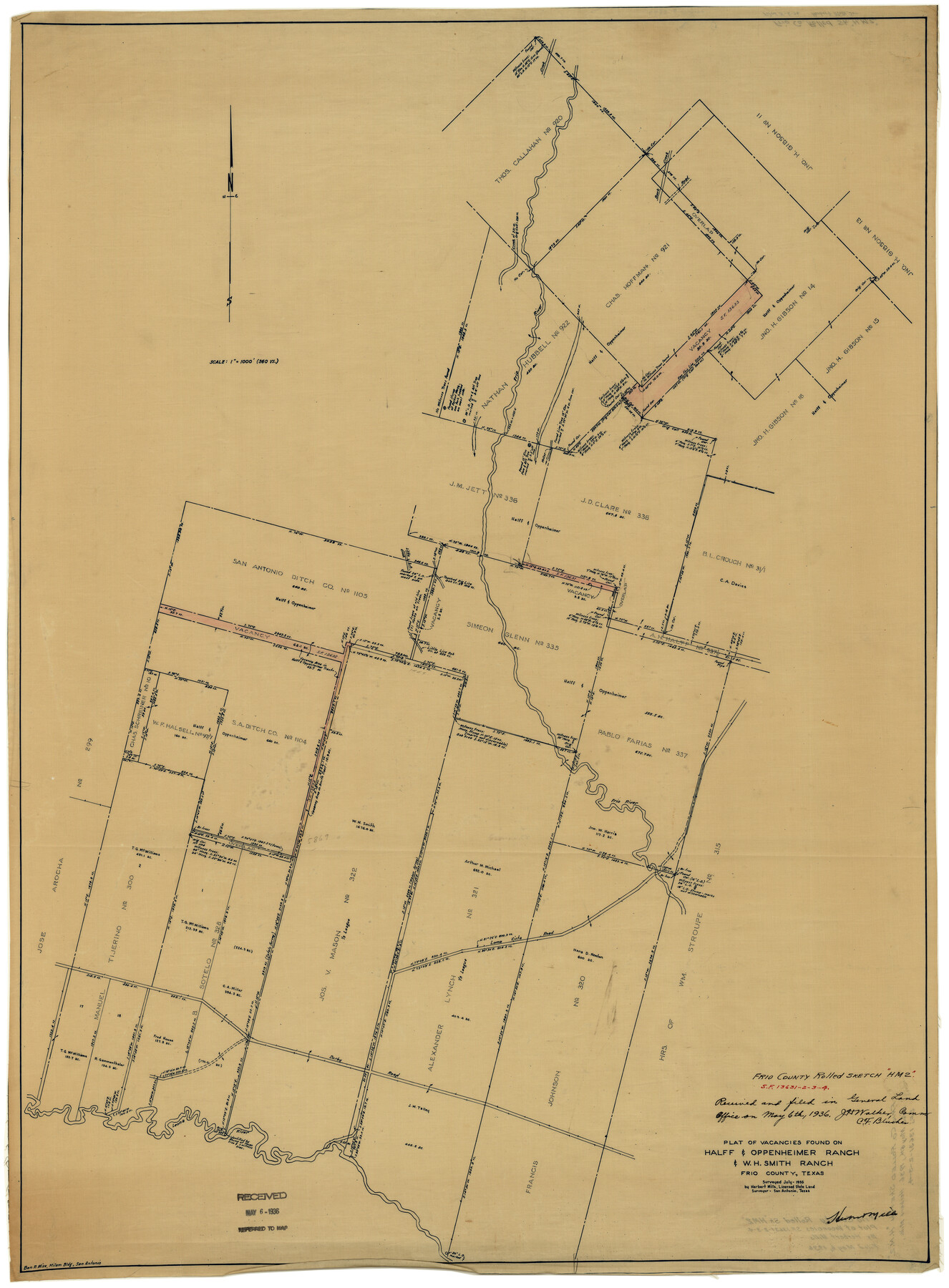
Frio County Rolled Sketch HM2
Plat of vacancies found on Halff & Oppenheimer Ranch & W.H. Smith Ranch, Frio County, Texas
-
Map/Doc
8899
-
Collection
General Map Collection
-
Object Dates
7/1935 (Creation Date)
5/6/1936 (File Date)
-
People and Organizations
Herbert Mills (Surveyor/Engineer)
-
Counties
Frio
-
Subjects
Surveying Rolled Sketch
-
Height x Width
41.3 x 30.6 inches
104.9 x 77.7 cm
-
Medium
van dyke/brownline/sepia
-
Scale
1" = 1000 feet
-
Comments
See Frio County Rolled Sketch HM (8898) for earlier sketch. Also see SF-13631, SF-13632, SF-13633, and SF-13634.
Related maps
Frio County Rolled Sketch HM

Print $20.00
- Digital $50.00
Frio County Rolled Sketch HM
1935
Size 41.2 x 30.6 inches
Map/Doc 8898
Part of: General Map Collection
South Part Presidio County

Print $20.00
- Digital $50.00
South Part Presidio County
1975
Size 34.0 x 39.3 inches
Map/Doc 73266
Rusk County Sketch File 44

Print $12.00
Rusk County Sketch File 44
1951
Size 11.3 x 8.9 inches
Map/Doc 35585
Burnet County Working Sketch 9

Print $20.00
- Digital $50.00
Burnet County Working Sketch 9
1975
Size 39.7 x 25.2 inches
Map/Doc 67852
Frio County Sketch File 22

Print $10.00
- Digital $50.00
Frio County Sketch File 22
1994
Size 11.4 x 8.6 inches
Map/Doc 23162
Brewster County Rolled Sketch 114

Print $20.00
- Digital $50.00
Brewster County Rolled Sketch 114
1964
Size 11.1 x 18.4 inches
Map/Doc 5270
Presidio County Sketch File 38

Print $8.00
- Digital $50.00
Presidio County Sketch File 38
1911
Size 11.2 x 8.7 inches
Map/Doc 34508
Galveston County Sketch File 70

Print $26.00
- Digital $50.00
Galveston County Sketch File 70
1983
Size 11.3 x 8.7 inches
Map/Doc 23928
Culberson County Working Sketch 24

Print $20.00
- Digital $50.00
Culberson County Working Sketch 24
1947
Size 36.8 x 36.2 inches
Map/Doc 68477
Lynn County Boundary File 4a

Print $6.00
- Digital $50.00
Lynn County Boundary File 4a
Size 14.3 x 8.8 inches
Map/Doc 56627
Leon County Working Sketch 27

Print $20.00
- Digital $50.00
Leon County Working Sketch 27
1970
Size 22.4 x 24.4 inches
Map/Doc 70426
Nueces County Sketch File 8

Print $22.00
- Digital $50.00
Nueces County Sketch File 8
1849
Size 8.2 x 12.4 inches
Map/Doc 32512
Montgomery County Sketch File 25

Print $4.00
- Digital $50.00
Montgomery County Sketch File 25
1839
Size 13.8 x 8.2 inches
Map/Doc 31869
You may also like
Maverick County Sketch File 2

Print $40.00
- Digital $50.00
Maverick County Sketch File 2
1875
Size 18.2 x 14.0 inches
Map/Doc 31031
Parmer County

Print $20.00
- Digital $50.00
Parmer County
1926
Size 39.8 x 31.6 inches
Map/Doc 77392
Polk County Working Sketch 33b

Print $20.00
- Digital $50.00
Polk County Working Sketch 33b
1960
Size 14.9 x 24.8 inches
Map/Doc 71650
Working Sketch Hemphill County

Print $20.00
- Digital $50.00
Working Sketch Hemphill County
1910
Size 6.9 x 39.1 inches
Map/Doc 90730
Limestone County Sketch File 10b

Print $22.00
- Digital $50.00
Limestone County Sketch File 10b
1875
Size 15.0 x 14.1 inches
Map/Doc 30175
Wilbarger County Sketch File 5

Print $4.00
- Digital $50.00
Wilbarger County Sketch File 5
Size 9.3 x 7.9 inches
Map/Doc 40170
Leon County Working Sketch 59

Print $20.00
- Digital $50.00
Leon County Working Sketch 59
1998
Size 19.2 x 25.5 inches
Map/Doc 70459
Dimmit County Working Sketch 19

Print $20.00
- Digital $50.00
Dimmit County Working Sketch 19
1948
Size 27.4 x 23.3 inches
Map/Doc 68680
[Galveston, Harrisburg & San Antonio through El Paso County]
![64002, [Galveston, Harrisburg & San Antonio through El Paso County], General Map Collection](https://historictexasmaps.com/wmedia_w700/maps/64002.tif.jpg)
Print $20.00
- Digital $50.00
[Galveston, Harrisburg & San Antonio through El Paso County]
1907
Size 13.6 x 33.9 inches
Map/Doc 64002
Fayette County Boundary File 1

Print $2.00
- Digital $50.00
Fayette County Boundary File 1
Size 11.1 x 8.7 inches
Map/Doc 53330
Flight Mission No. CUG-1P, Frame 20, Kleberg County

Print $20.00
- Digital $50.00
Flight Mission No. CUG-1P, Frame 20, Kleberg County
1956
Size 18.6 x 22.4 inches
Map/Doc 86110
Flight Mission No. CRE-1R, Frame 64, Jackson County

Print $20.00
- Digital $50.00
Flight Mission No. CRE-1R, Frame 64, Jackson County
1956
Size 15.9 x 15.9 inches
Map/Doc 85327