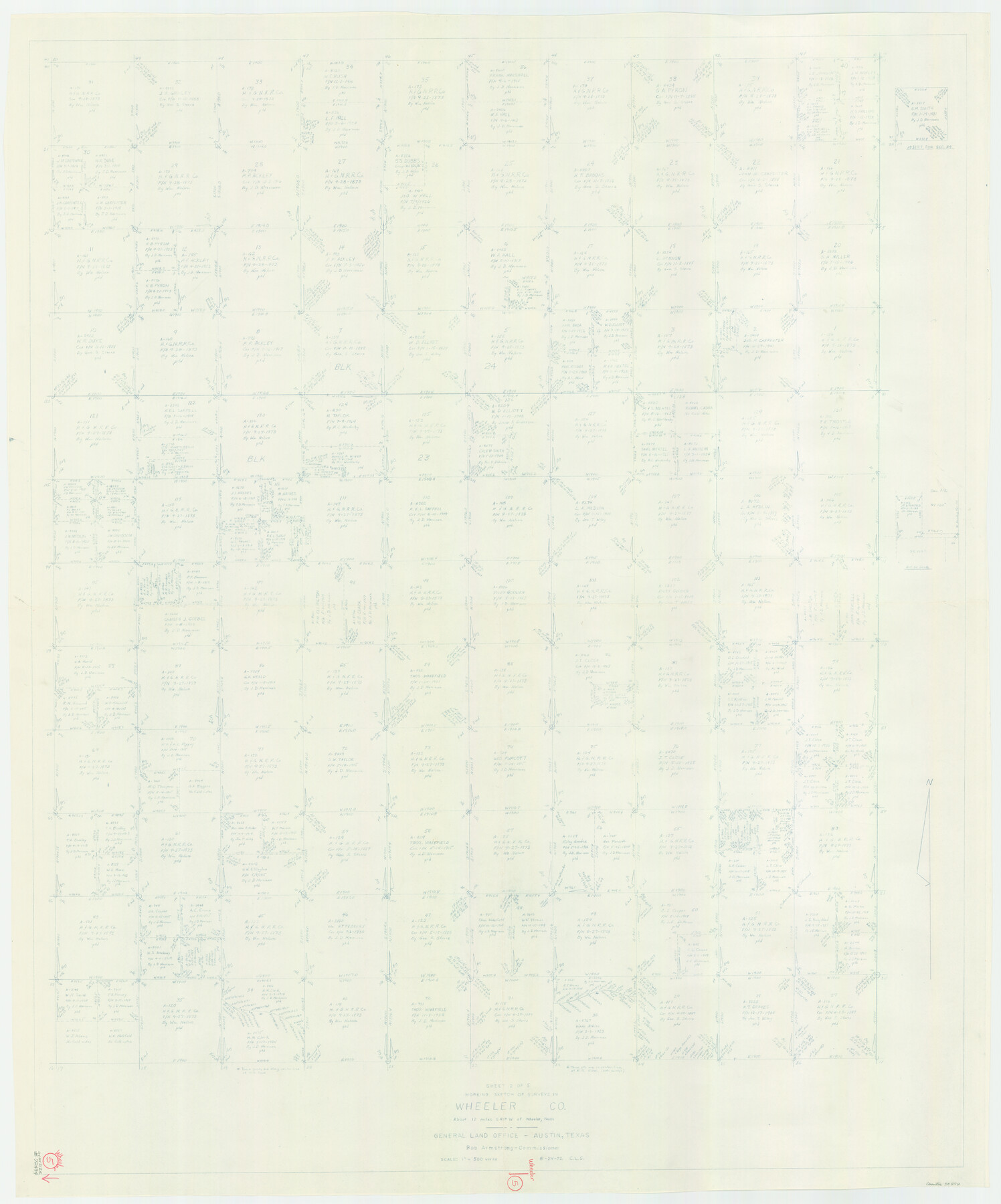
Wheeler County Working Sketch 5
-
Map/Doc
72494
-
Collection
General Map Collection
-
Object Dates
8/24/1972 (Creation Date)
-
People and Organizations
Crockett L. Slover (Draftsman)
-
Counties
Wheeler
-
Subjects
Surveying Working Sketch
-
Height x Width
55.3 x 45.9 inches
140.5 x 116.6 cm
-
Scale
1" = 500 varas
Part of: General Map Collection
Parmer County

Print $20.00
- Digital $50.00
Parmer County
1926
Size 43.9 x 35.4 inches
Map/Doc 73259
Upton County Rolled Sketch 45

Print $20.00
- Digital $50.00
Upton County Rolled Sketch 45
Size 25.1 x 43.8 inches
Map/Doc 8081
Map of subdivision of submerged land in the Gulf of Mexico fronting on Matagorda Island and Peninsula

Print $40.00
- Digital $50.00
Map of subdivision of submerged land in the Gulf of Mexico fronting on Matagorda Island and Peninsula
1940
Size 28.3 x 60.5 inches
Map/Doc 2928
Atascosa County Sketch File 41

Print $8.00
- Digital $50.00
Atascosa County Sketch File 41
1956
Size 11.3 x 8.8 inches
Map/Doc 13837
Galveston County Rolled Sketch 33

Print $40.00
- Digital $50.00
Galveston County Rolled Sketch 33
1928
Size 26.3 x 140.3 inches
Map/Doc 9016
Current Miscellaneous File 45

Print $4.00
- Digital $50.00
Current Miscellaneous File 45
1954
Size 11.2 x 8.8 inches
Map/Doc 73988
Red River County Sketch File 7

Print $6.00
- Digital $50.00
Red River County Sketch File 7
1855
Size 12.7 x 8.0 inches
Map/Doc 35109
Marion County Rolled Sketch 6

Print $20.00
- Digital $50.00
Marion County Rolled Sketch 6
1979
Size 12.2 x 18.3 inches
Map/Doc 6659

University Lands Hudspeth County, Texas, Blocks A to N

Print $40.00
- Digital $50.00
University Lands Hudspeth County, Texas, Blocks A to N
1935
Size 38.6 x 55.4 inches
Map/Doc 2447
Victoria County Rolled Sketch 8

Print $20.00
- Digital $50.00
Victoria County Rolled Sketch 8
Size 34.2 x 27.5 inches
Map/Doc 8153
Fisher County Sketch File 24

Print $37.00
- Digital $50.00
Fisher County Sketch File 24
1875
Size 14.3 x 8.9 inches
Map/Doc 22666
You may also like
Flight Mission No. DQO-8K, Frame 42, Galveston County

Print $20.00
- Digital $50.00
Flight Mission No. DQO-8K, Frame 42, Galveston County
1952
Size 18.5 x 22.3 inches
Map/Doc 85149
Hopkins County Sketch File 11

Print $4.00
- Digital $50.00
Hopkins County Sketch File 11
Size 7.7 x 7.7 inches
Map/Doc 26704
Harris County State Real Property Sketch 3

Print $42.00
- Digital $50.00
Harris County State Real Property Sketch 3
2004
Size 24.9 x 36.9 inches
Map/Doc 81952
Edwards County Sketch File 48

Print $6.00
- Digital $50.00
Edwards County Sketch File 48
1955
Size 9.7 x 7.6 inches
Map/Doc 21797
Cooke County Working Sketch 12

Print $20.00
- Digital $50.00
Cooke County Working Sketch 12
1944
Size 25.2 x 23.0 inches
Map/Doc 68249
Hill County Sketch File 16

Print $4.00
- Digital $50.00
Hill County Sketch File 16
1860
Size 9.9 x 8.3 inches
Map/Doc 26482
Map of Harrison County, Texas

Print $20.00
- Digital $50.00
Map of Harrison County, Texas
1879
Size 20.2 x 21.9 inches
Map/Doc 375
Live Oak County Boundary File 60

Print $12.00
- Digital $50.00
Live Oak County Boundary File 60
Size 8.8 x 7.6 inches
Map/Doc 56401
Geological Map of the route explored by Capt. Jno. Pope, Corps of Topl. Engrs. near the 32nd Parallel of North Latitude From the Red River to the Rio Grande

Print $20.00
- Digital $50.00
Geological Map of the route explored by Capt. Jno. Pope, Corps of Topl. Engrs. near the 32nd Parallel of North Latitude From the Red River to the Rio Grande
Size 11.5 x 24.7 inches
Map/Doc 95149
Map of Eastland County, the portion on the waters of Colorado River, Travis - the balance, Milam Land District

Print $20.00
- Digital $50.00
Map of Eastland County, the portion on the waters of Colorado River, Travis - the balance, Milam Land District
1860
Size 23.8 x 21.5 inches
Map/Doc 3501
Texas Intracoastal Waterway - Port O'Connor to San Antonio Bay, Including Pass Cavallo

Print $20.00
- Digital $50.00
Texas Intracoastal Waterway - Port O'Connor to San Antonio Bay, Including Pass Cavallo
1961
Size 26.4 x 38.8 inches
Map/Doc 73374
Aransas County Working Sketch 23

Print $20.00
- Digital $50.00
Aransas County Working Sketch 23
1970
Size 34.6 x 40.1 inches
Map/Doc 67190