Atascosa County Sketch File 41
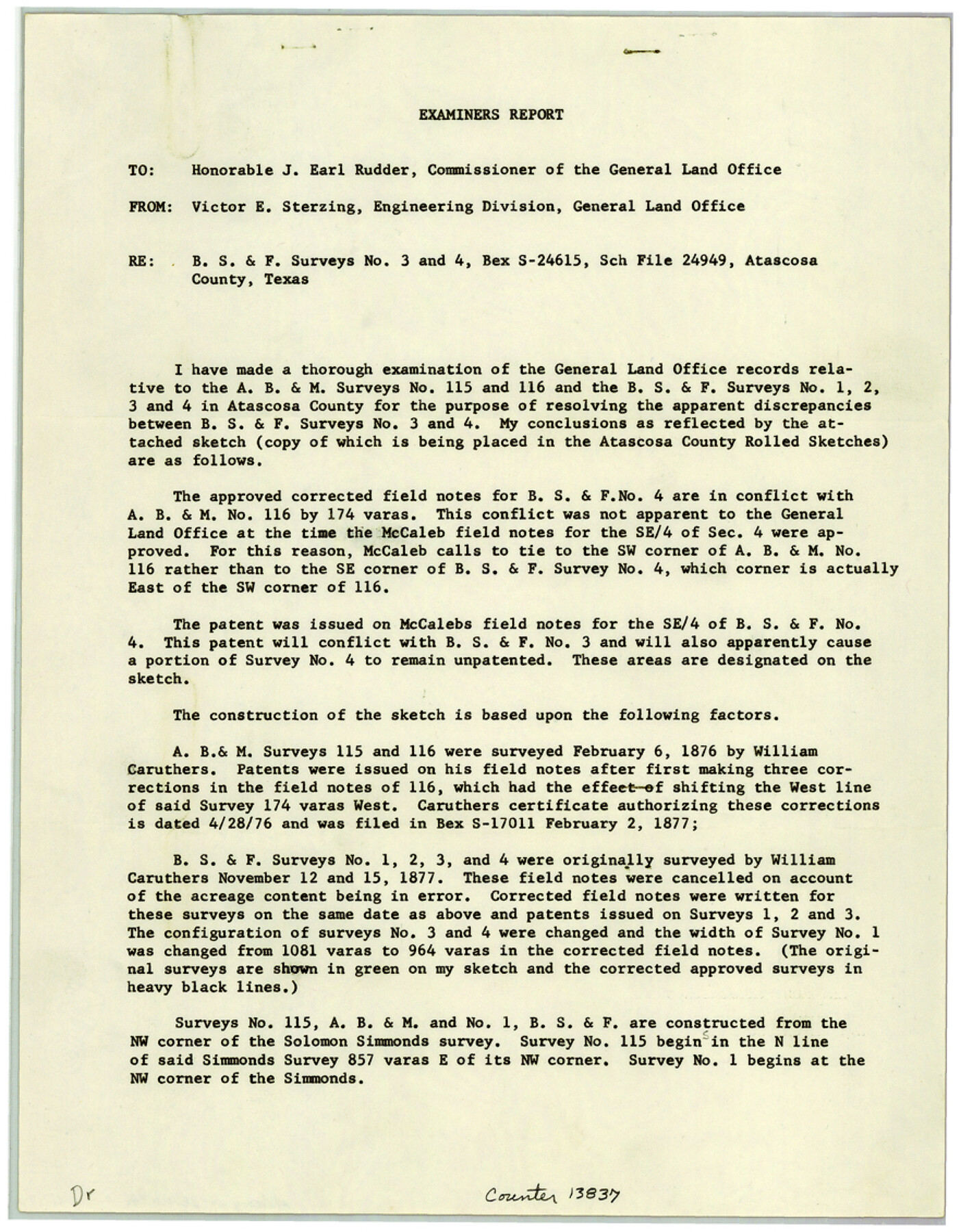
[Examiner's report on construction of office sketch - B. S. & F. surveys 1, 2, 3, and 4 and A. B. & M. surveys 115 and 116]
-
Map/Doc
13837
-
Collection
General Map Collection
-
Object Dates
1956 (Creation Date)
1956/5/4 (File Date)
-
People and Organizations
Victor E. Sterzing (Surveyor/Engineer)
J. Earl Rudder (GLO Commissioner)
-
Counties
Atascosa
-
Subjects
Surveying Sketch File
-
Height x Width
11.3 x 8.8 inches
28.7 x 22.4 cm
-
Medium
paper, print
-
Comments
See Atascosa County Rolled Sketch 20 (8432) for sketch.
Related maps
Atascosa County Rolled Sketch 20

Print $20.00
- Digital $50.00
Atascosa County Rolled Sketch 20
1956
Size 36.0 x 44.0 inches
Map/Doc 8432
Part of: General Map Collection
Atascosa County Boundary File 4

Print $80.00
- Digital $50.00
Atascosa County Boundary File 4
Size 30.6 x 59.2 inches
Map/Doc 50177
Austin Old and New, a Mapguide to the Heart of the City including Capitol Complex & Government Buildings, Downtown Streets and Buildings, the University of Texas, Historical Sites, Parks & Trails, Sixth Street, Town Lake, Museums

Austin Old and New, a Mapguide to the Heart of the City including Capitol Complex & Government Buildings, Downtown Streets and Buildings, the University of Texas, Historical Sites, Parks & Trails, Sixth Street, Town Lake, Museums
Size 25.4 x 31.2 inches
Map/Doc 94380
Brooks County Rolled Sketch 27

Print $20.00
- Digital $50.00
Brooks County Rolled Sketch 27
1945
Size 44.5 x 42.9 inches
Map/Doc 8540
Throckmorton County Working Sketch 4

Print $20.00
- Digital $50.00
Throckmorton County Working Sketch 4
1949
Size 25.0 x 24.9 inches
Map/Doc 62113
Flight Mission No. BRE-2P, Frame 24, Nueces County

Print $20.00
- Digital $50.00
Flight Mission No. BRE-2P, Frame 24, Nueces County
1956
Size 17.8 x 21.0 inches
Map/Doc 86733
Hamilton County Working Sketch 4

Print $20.00
- Digital $50.00
Hamilton County Working Sketch 4
1935
Size 32.6 x 36.9 inches
Map/Doc 63342
Colorado River, Hungerford Sheet

Print $6.00
- Digital $50.00
Colorado River, Hungerford Sheet
1941
Size 24.1 x 35.4 inches
Map/Doc 65309
Lavaca County

Print $40.00
- Digital $50.00
Lavaca County
1946
Size 51.1 x 42.8 inches
Map/Doc 73216
Current Miscellaneous File 40

Print $10.00
- Digital $50.00
Current Miscellaneous File 40
Size 14.2 x 8.7 inches
Map/Doc 73972
Nueces County NRC Article 33.136 Sketch 9

Print $32.00
- Digital $50.00
Nueces County NRC Article 33.136 Sketch 9
2005
Size 22.2 x 33.5 inches
Map/Doc 83414
Montague County Working Sketch 8

Print $20.00
- Digital $50.00
Montague County Working Sketch 8
1928
Size 20.9 x 18.9 inches
Map/Doc 71074
Concho County Sketch File 4

Print $2.00
- Digital $50.00
Concho County Sketch File 4
1858
Size 8.0 x 10.1 inches
Map/Doc 82523
You may also like
Montgomery County Rolled Sketch 42

Print $20.00
- Digital $50.00
Montgomery County Rolled Sketch 42
1939
Size 13.9 x 20.2 inches
Map/Doc 6816
[County table portion of 1879 State of Texas map by Pressler & Langermann]
![3102, [County table portion of 1879 State of Texas map by Pressler & Langermann], General Map Collection](https://historictexasmaps.com/wmedia_w700/maps/3102-1.tif.jpg)
Print $20.00
- Digital $50.00
[County table portion of 1879 State of Texas map by Pressler & Langermann]
1879
Size 15.0 x 23.6 inches
Map/Doc 3102
Flight Mission No. DQN-2K, Frame 21, Calhoun County

Print $20.00
- Digital $50.00
Flight Mission No. DQN-2K, Frame 21, Calhoun County
1953
Size 18.8 x 22.3 inches
Map/Doc 84228
Hamilton County Working Sketch 15

Print $40.00
- Digital $50.00
Hamilton County Working Sketch 15
1949
Size 54.5 x 37.6 inches
Map/Doc 63353
General Highway Map, Jim Wells County, Texas

Print $20.00
General Highway Map, Jim Wells County, Texas
1940
Size 18.4 x 24.8 inches
Map/Doc 79147
Polk County Working Sketch 27

Print $40.00
- Digital $50.00
Polk County Working Sketch 27
1960
Size 45.9 x 51.2 inches
Map/Doc 71643
Red River County Working Sketch 60

Print $20.00
- Digital $50.00
Red River County Working Sketch 60
1973
Size 27.1 x 40.0 inches
Map/Doc 72043
Refugio County Sketch File 21

Print $20.00
- Digital $50.00
Refugio County Sketch File 21
1933
Size 17.8 x 22.1 inches
Map/Doc 12248
Dickens County Working Sketch Graphic Index

Print $20.00
- Digital $50.00
Dickens County Working Sketch Graphic Index
1963
Size 42.5 x 33.6 inches
Map/Doc 76523
General Highway Map, Terrell County, Texas

Print $20.00
General Highway Map, Terrell County, Texas
1940
Size 24.9 x 18.4 inches
Map/Doc 79256
Fisher County Sketch File A2

Print $20.00
- Digital $50.00
Fisher County Sketch File A2
1901
Size 35.8 x 31.0 inches
Map/Doc 10450
Galveston County Sketch File 57

Print $8.00
- Digital $50.00
Galveston County Sketch File 57
1910
Size 8.1 x 5.2 inches
Map/Doc 23603