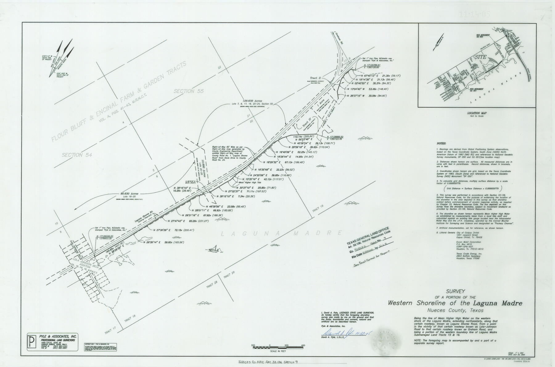
Nueces County NRC Article 33.136 Sketch 9
A Survey of a portion of the western shoreline of the Laguna Madre, Flour Bluff
-
Map/Doc
83414
-
Collection
General Map Collection
-
Object Dates
7/20/2005 (Creation Date)
12/15/2005 (File Date)
-
People and Organizations
David A. Pyle (Surveyor/Engineer)
-
Counties
Nueces
-
Subjects
Surveying CBS
-
Height x Width
22.2 x 33.5 inches
56.4 x 85.1 cm
-
Medium
multi-page, multi-format
-
Comments
Survey located about 12 miles South 40 degrees East of Corpus Christi, Texas.
Part of: General Map Collection
[Sketch for Mineral Application 26501 - Sabine River, T. A. Oldhausen]
![2840, [Sketch for Mineral Application 26501 - Sabine River, T. A. Oldhausen], General Map Collection](https://historictexasmaps.com/wmedia_w700/maps/2840.tif.jpg)
Print $20.00
- Digital $50.00
[Sketch for Mineral Application 26501 - Sabine River, T. A. Oldhausen]
1931
Size 24.3 x 35.5 inches
Map/Doc 2840
Flight Mission No. DIX-8P, Frame 62, Aransas County

Print $20.00
- Digital $50.00
Flight Mission No. DIX-8P, Frame 62, Aransas County
1956
Size 18.5 x 22.2 inches
Map/Doc 83893
Hopkins County Sketch File 2a

Print $4.00
- Digital $50.00
Hopkins County Sketch File 2a
Size 13.6 x 8.6 inches
Map/Doc 26683
Culberson County Rolled Sketch 68

Print $20.00
- Digital $50.00
Culberson County Rolled Sketch 68
1997
Size 32.0 x 32.9 inches
Map/Doc 76402
Flight Mission No. CRC-3R, Frame 200, Chambers County

Print $20.00
- Digital $50.00
Flight Mission No. CRC-3R, Frame 200, Chambers County
1956
Size 18.6 x 22.2 inches
Map/Doc 84855

Edwards County Rolled Sketch JFW1

Print $53.00
- Digital $50.00
Edwards County Rolled Sketch JFW1
1935
Size 10.3 x 15.5 inches
Map/Doc 44398
Flight Mission No. DCL-6C, Frame 120, Kenedy County

Print $20.00
- Digital $50.00
Flight Mission No. DCL-6C, Frame 120, Kenedy County
1943
Size 18.4 x 22.3 inches
Map/Doc 85950
Grayson County Sketch File 5

Print $40.00
- Digital $50.00
Grayson County Sketch File 5
1856
Size 13.9 x 14.5 inches
Map/Doc 24464
Map of San Augustine County

Print $20.00
- Digital $50.00
Map of San Augustine County
1841
Size 20.5 x 16.9 inches
Map/Doc 4013
Montague County Working Sketch 16

Print $20.00
- Digital $50.00
Montague County Working Sketch 16
1946
Size 44.1 x 40.8 inches
Map/Doc 71082
Hunt County Sketch File 40

Print $4.00
- Digital $50.00
Hunt County Sketch File 40
Size 7.6 x 8.0 inches
Map/Doc 27163
You may also like
Galveston County NRC Article 33.136 Sketch 2

Print $46.00
- Digital $50.00
Galveston County NRC Article 33.136 Sketch 2
2000
Size 23.1 x 34.4 inches
Map/Doc 61565
Current Miscellaneous File 20

Print $22.00
- Digital $50.00
Current Miscellaneous File 20
1952
Size 10.7 x 8.1 inches
Map/Doc 73855
Flight Mission No. CUG-1P, Frame 114, Kleberg County

Print $20.00
- Digital $50.00
Flight Mission No. CUG-1P, Frame 114, Kleberg County
1956
Size 18.5 x 22.1 inches
Map/Doc 86164
Edwards County Working Sketch 60

Print $20.00
- Digital $50.00
Edwards County Working Sketch 60
1954
Size 20.5 x 43.7 inches
Map/Doc 68936
Brewster County Rolled Sketch 101

Print $40.00
- Digital $50.00
Brewster County Rolled Sketch 101
1927
Size 55.0 x 40.0 inches
Map/Doc 8509
Newton County Rolled Sketch 25

Print $20.00
- Digital $50.00
Newton County Rolled Sketch 25
1893
Size 22.4 x 18.7 inches
Map/Doc 6853
Brewster County Working Sketch 71b

Print $40.00
- Digital $50.00
Brewster County Working Sketch 71b
1961
Size 50.6 x 55.0 inches
Map/Doc 67870
Limestone County Sketch File 5a

Print $6.00
- Digital $50.00
Limestone County Sketch File 5a
1858
Size 9.4 x 7.3 inches
Map/Doc 30164

Schleicher County Sketch File 30

Print $4.00
- Digital $50.00
Schleicher County Sketch File 30
1940
Size 11.3 x 8.8 inches
Map/Doc 36528
Irion County Sketch File 5

Print $16.00
- Digital $50.00
Irion County Sketch File 5
1900
Size 14.4 x 8.9 inches
Map/Doc 27463
Map of Randall County

Print $20.00
- Digital $50.00
Map of Randall County
1893
Size 26.5 x 20.0 inches
Map/Doc 73338