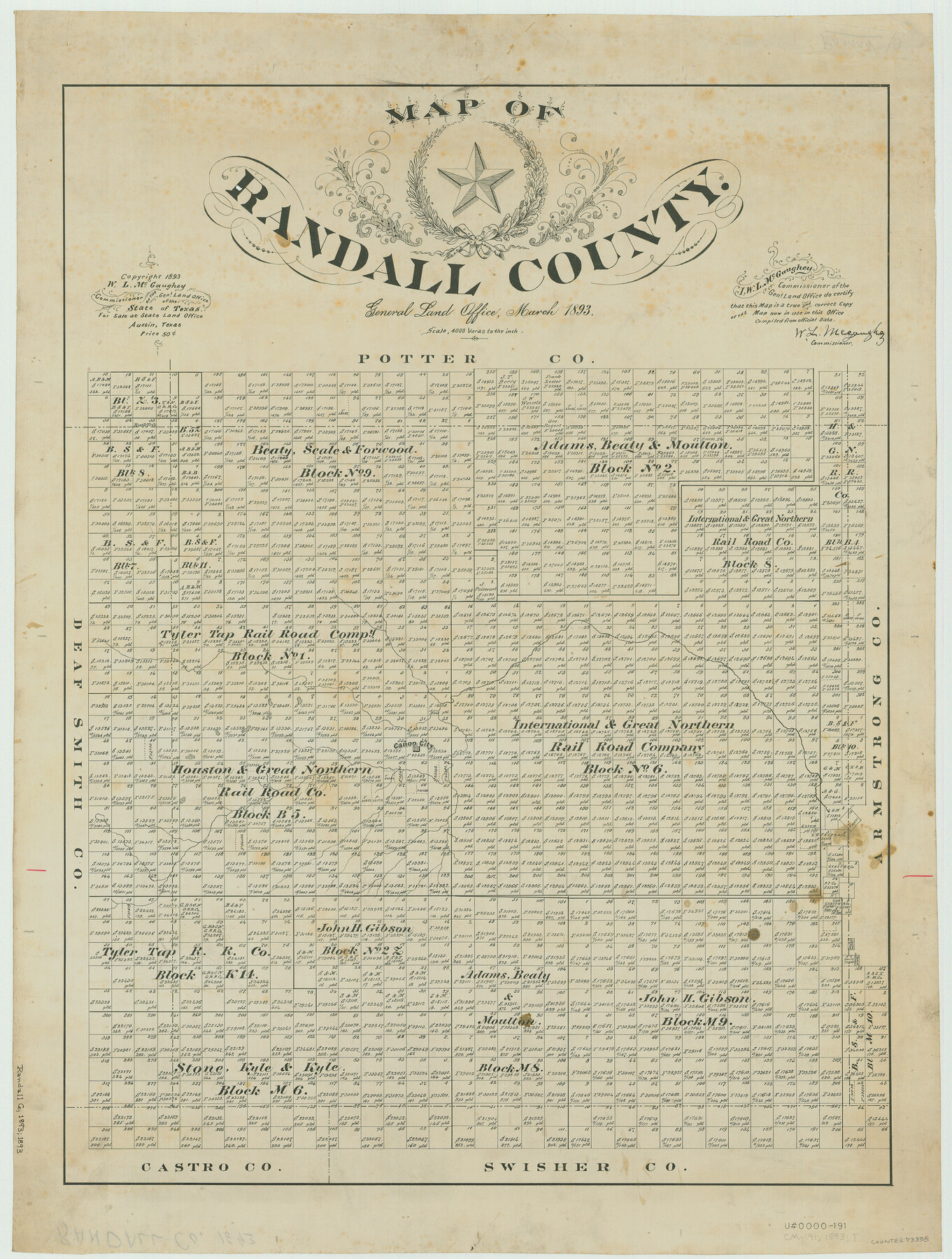
Map of Randall County
-
Map/Doc
73338
-
Collection
General Map Collection
-
Object Dates
1893 (Creation Date)
-
People and Organizations
Texas General Land Office (Publisher)
W.L. McGaughey (GLO Commissioner)
-
Counties
Randall
-
Subjects
County
-
Height x Width
26.5 x 20.0 inches
67.3 x 50.8 cm
-
Comments
Copyrighted 1893.
Part of: General Map Collection
Terry County Boundary File 3

Print $78.00
- Digital $50.00
Terry County Boundary File 3
Size 7.4 x 8.8 inches
Map/Doc 59216
Kendall County Working Sketch 22

Print $20.00
- Digital $50.00
Kendall County Working Sketch 22
1971
Size 41.6 x 34.7 inches
Map/Doc 66694
Colorado River, Lissie Sheet

Print $20.00
- Digital $50.00
Colorado River, Lissie Sheet
1941
Size 24.2 x 43.0 inches
Map/Doc 65306
Loving County Working Sketch 13

Print $40.00
- Digital $50.00
Loving County Working Sketch 13
1957
Size 48.4 x 34.6 inches
Map/Doc 70646
Terrell County Working Sketch 77

Print $20.00
- Digital $50.00
Terrell County Working Sketch 77
1983
Size 22.9 x 33.7 inches
Map/Doc 69598
Flight Mission No. BQR-14K, Frame 35, Brazoria County

Print $20.00
- Digital $50.00
Flight Mission No. BQR-14K, Frame 35, Brazoria County
1952
Size 18.5 x 22.2 inches
Map/Doc 84092

McMullen County Working Sketch 47

Print $40.00
- Digital $50.00
McMullen County Working Sketch 47
1983
Size 55.8 x 43.3 inches
Map/Doc 70748
Flight Mission No. BRA-7M, Frame 125, Jefferson County

Print $20.00
- Digital $50.00
Flight Mission No. BRA-7M, Frame 125, Jefferson County
1953
Size 16.3 x 16.1 inches
Map/Doc 85519
Ward County Rolled Sketch 25

Print $20.00
- Digital $50.00
Ward County Rolled Sketch 25
1970
Size 38.7 x 19.9 inches
Map/Doc 8165
Galveston County NRC Article 33.136 Sketch 38

Print $28.00
- Digital $50.00
Galveston County NRC Article 33.136 Sketch 38
2006
Size 24.4 x 18.6 inches
Map/Doc 83079
Milam County Boundary File 6c

Print $2.00
- Digital $50.00
Milam County Boundary File 6c
Size 11.2 x 8.5 inches
Map/Doc 57250
You may also like
Flight Mission No. DCL-6C, Frame 177, Kenedy County

Print $20.00
- Digital $50.00
Flight Mission No. DCL-6C, Frame 177, Kenedy County
1943
Size 18.5 x 22.2 inches
Map/Doc 85989

Brazoria County Sketch File 44

Print $30.00
- Digital $50.00
Brazoria County Sketch File 44
1946
Size 11.3 x 8.9 inches
Map/Doc 15068
[Folder for] Nautical Chart 11305: Texas Intracoastal Waterway, Laguna Madre, Rincon de San Jose to Chubby Island
![75913, [Folder for] Nautical Chart 11305: Texas Intracoastal Waterway, Laguna Madre, Rincon de San Jose to Chubby Island, General Map Collection](https://historictexasmaps.com/wmedia_w700/maps/75913-1.tif.jpg)
Print $20.00
- Digital $50.00
[Folder for] Nautical Chart 11305: Texas Intracoastal Waterway, Laguna Madre, Rincon de San Jose to Chubby Island
1976
Size 16.0 x 19.0 inches
Map/Doc 75913

General Highway Map, Callahan County, Texas

Print $20.00
General Highway Map, Callahan County, Texas
1961
Size 25.0 x 18.2 inches
Map/Doc 79396
Gulf Intracoastal Waterway, Tex. - Aransas Bay to Corpus Christi Bay - Modified Route of Main Channel/Dredging

Print $20.00
- Digital $50.00
Gulf Intracoastal Waterway, Tex. - Aransas Bay to Corpus Christi Bay - Modified Route of Main Channel/Dredging
1958
Size 31.3 x 42.6 inches
Map/Doc 61894

Brewster County Rolled Sketch 115

Print $40.00
- Digital $50.00
Brewster County Rolled Sketch 115
1958
Size 11.5 x 138.4 inches
Map/Doc 8514
Culberson County Rolled Sketch 46

Print $40.00
- Digital $50.00
Culberson County Rolled Sketch 46
1953
Size 53.1 x 43.1 inches
Map/Doc 8754
Edwards County Sketch File 6

Print $20.00
- Digital $50.00
Edwards County Sketch File 6
1880
Size 11.7 x 19.6 inches
Map/Doc 11419
The Republic County of Harrison. December 31, 1844

Print $20.00
The Republic County of Harrison. December 31, 1844
2020
Size 18.6 x 21.7 inches
Map/Doc 96176