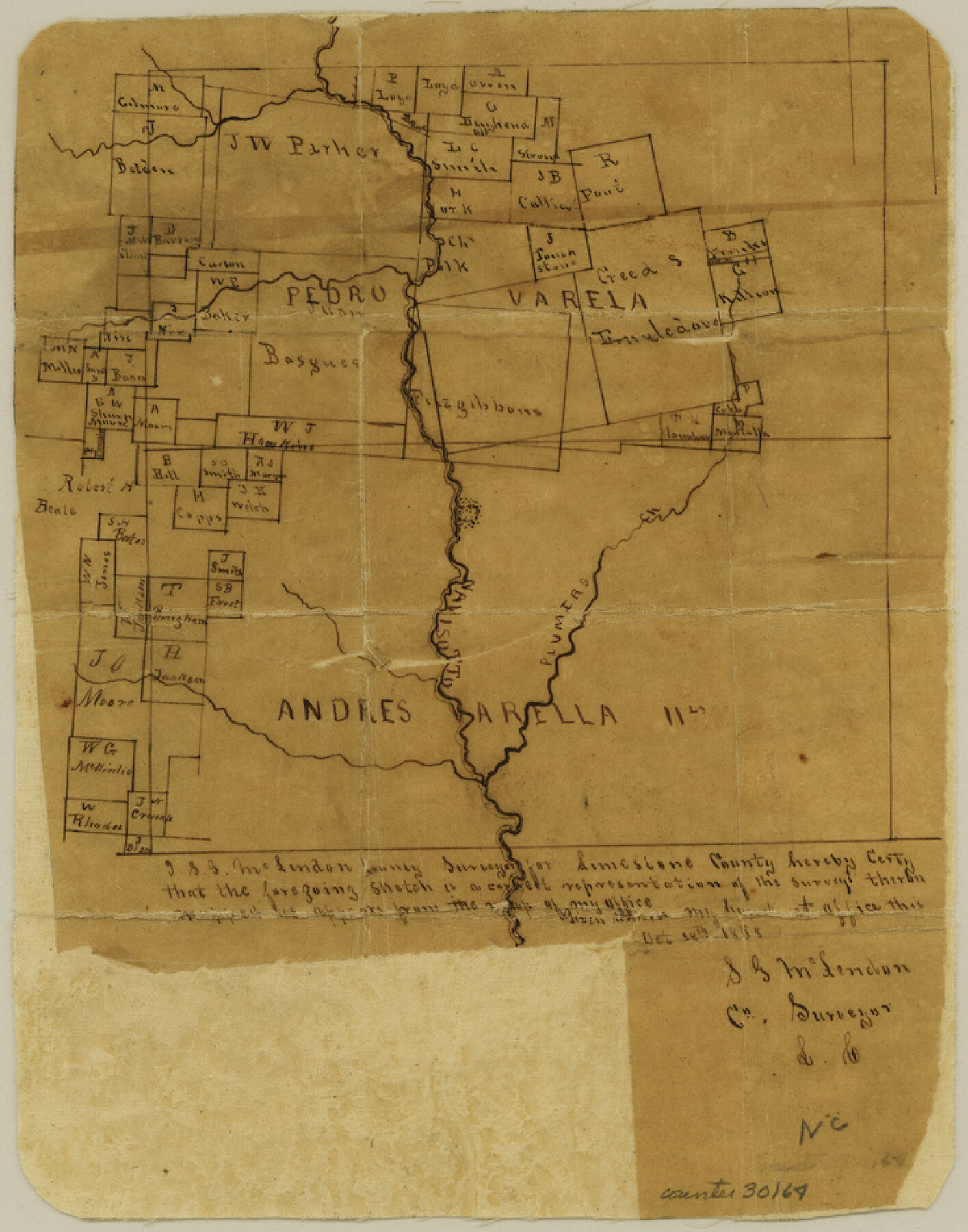
Limestone County Sketch File 5a
[Sketch of Pedro and Andres Varela grants]
-
Map/Doc
30164
-
Collection
General Map Collection
-
Object Dates
10/18/1858 (Creation Date)
-
People and Organizations
S.T. McLendon (Surveyor/Engineer)
-
Counties
Limestone
-
Subjects
Surveying Sketch File
-
Height x Width
9.4 x 7.3 inches
23.9 x 18.5 cm
-
Medium
paper, manuscript
-
Features
Plumirs [sic] Creek
Navisotto [sic] River
Part of: General Map Collection
Liberty County Rolled Sketch N

Print $20.00
- Digital $50.00
Liberty County Rolled Sketch N
Size 38.4 x 47.9 inches
Map/Doc 10181
Texas City Channel, Texas, Channel and Turning Basin Dredging - Sheet 5

Print $20.00
- Digital $50.00
Texas City Channel, Texas, Channel and Turning Basin Dredging - Sheet 5
1958
Size 28.2 x 40.9 inches
Map/Doc 61835

Pecos County Sketch File 60

Print $6.00
- Digital $50.00
Pecos County Sketch File 60
Size 8.2 x 16.5 inches
Map/Doc 33786
Matagorda County Rolled Sketch 35

Print $20.00
- Digital $50.00
Matagorda County Rolled Sketch 35
1903
Size 18.6 x 38.0 inches
Map/Doc 6696
Martin County Sketch File 12

Print $20.00
- Digital $50.00
Martin County Sketch File 12
1937
Size 22.9 x 19.5 inches
Map/Doc 12030
Real County Working Sketch 45

Print $20.00
- Digital $50.00
Real County Working Sketch 45
1955
Size 23.1 x 18.5 inches
Map/Doc 71937
Morris County Rolled Sketch 2A

Print $20.00
- Digital $50.00
Morris County Rolled Sketch 2A
Size 13.4 x 19.1 inches
Map/Doc 10231
Flight Mission No. DQO-8K, Frame 20, Galveston County

Print $20.00
- Digital $50.00
Flight Mission No. DQO-8K, Frame 20, Galveston County
1952
Size 18.8 x 22.3 inches
Map/Doc 85143
Menard County Working Sketch 2

Print $20.00
- Digital $50.00
Menard County Working Sketch 2
1906
Size 17.8 x 12.5 inches
Map/Doc 70949
Brazos County Working Sketch 7

Print $20.00
- Digital $50.00
Brazos County Working Sketch 7
1981
Size 12.1 x 33.1 inches
Map/Doc 67482
Anderson County Boundary File 2

Print $8.00
- Digital $50.00
Anderson County Boundary File 2
Size 14.3 x 8.7 inches
Map/Doc 49730
You may also like
Hamilton County Sketch File 14

Print $10.00
- Digital $50.00
Hamilton County Sketch File 14
Size 10.1 x 8.0 inches
Map/Doc 24937

Flight Mission No. DQO-8K, Frame 51, Galveston County

Print $20.00
- Digital $50.00
Flight Mission No. DQO-8K, Frame 51, Galveston County
1952
Size 18.7 x 22.3 inches
Map/Doc 85158
Houston County Sketch File 38

Print $8.00
- Digital $50.00
Houston County Sketch File 38
Size 12.8 x 8.3 inches
Map/Doc 26821
Uvalde County Sketch File 28

Print $10.00
- Digital $50.00
Uvalde County Sketch File 28
1980
Size 14.8 x 8.9 inches
Map/Doc 39023
Hudspeth County Working Sketch 47

Print $20.00
- Digital $50.00
Hudspeth County Working Sketch 47
1984
Size 27.3 x 38.6 inches
Map/Doc 78211
Val Verde County Sketch File XXX

Print $30.00
- Digital $50.00
Val Verde County Sketch File XXX
1908
Size 39.2 x 24.6 inches
Map/Doc 10424
Morton Independent School District, Cochran County, Texas

Print $20.00
- Digital $50.00
Morton Independent School District, Cochran County, Texas
Size 26.3 x 23.9 inches
Map/Doc 92519
[Surveys East of river copied from U.S. map of Township No. 6 South, Range No. 9 West of the Indian Meridian, Oklahoma]
![75185, [Surveys East of river copied from U.S. map of Township No. 6 South, Range No. 9 West of the Indian Meridian, Oklahoma], General Map Collection](https://historictexasmaps.com/wmedia_w700/maps/75185.tif.jpg)
Print $2.00
- Digital $50.00
[Surveys East of river copied from U.S. map of Township No. 6 South, Range No. 9 West of the Indian Meridian, Oklahoma]
Size 13.3 x 9.0 inches
Map/Doc 75185
Uvalde County Working Sketch 17

Print $20.00
- Digital $50.00
Uvalde County Working Sketch 17
1947
Size 27.5 x 37.3 inches
Map/Doc 72087
United States - Gulf Coast Texas - Southern part of Laguna Madre

Print $20.00
- Digital $50.00
United States - Gulf Coast Texas - Southern part of Laguna Madre
1941
Size 26.4 x 18.2 inches
Map/Doc 72956
Terrell County Sketch File 32

Print $6.00
- Digital $50.00
Terrell County Sketch File 32
1940
Size 11.4 x 8.7 inches
Map/Doc 37981